As for Feb...will worry about that later but last Feb it looked like winter over with this pattern below. But a few days after the outerbanks/east-NC got 10"+ of snow.

I gotta say 21-22 keeps ringing bells in my mind too, especially if we go heavy -EPO but we lose -NAO. We got storms that January but East Coast went over to rain with one of them. Christmas was warm in 2021.One of the favored analogs has been 2021-2. This was the GEFS PNA forecast 4 years ago today through Jan 14, 2022: it showed the PNA turning positive, which it did but the mean wasn’t positive enough for midmonth:
View attachment 180677
To compare, here’s today’s GEFS PNA forecast, which is clearly going in the right direction at the end but still isn’t then yet a +PNA. Note the wide spread of the members, however:
View attachment 180678


At least we got blocking over top, it doesn't know what to do with rest of crap lol
Lol yeh idk brother. Looks like the North Pole is right up the road. I’ll take it. Supports the unleash of cold air we all are thinking mid month.

I guess that's possible, but that's an odd look?
I mean, yeah...I'm more reacting to the fact that the best images continue to show up in the last couple of frames run after run. And even here, we're hoping that we can get a few tweaks at 360 to make things head in the right direction.Lol yeh idk brother. Looks like the North Pole is right up the road. I’ll take it. Supports the unleash of cold air we all are thinking mid month. View attachment 180691
It's not that bad with a sprawling coast-to-coast Arctic high, and Miller B look. Needs work, of course, and kicks the can until the LP over the Arklatex goes by.


I was literally typing that post. I like where this is headed. Let’s see where it goes.Well, there's this.
View attachment 180694
Yeh that’s very true.. that’s a good pointI mean, yeah...I'm more reacting to the fact that the best images continue to show up in the last couple of frames run after run. And even here, we're hoping that we can get a few tweaks at 360 to make things head in the right direction.
But, it's just a long range Op run. They waffle all the time. Hopefully the ENS will look good when they come out.

Very possible. Initially likely.Is it possible that the SE ridge hangs around and the cold goes towards the south central US?
Idk why, but this is kinda reminding me of 2021 February.Very possible. Initially likely.


She's steady.

Yeah, I’ve tried to make an animation for it. The block stays anchored in place!
It just seems that way because we're all looking out past 7-10 days for something to keep hope alive. IMO, of course.Is it me or the GEFS and GFS is less reliable than it used to
Even the ECMWF also

That just be that please that is mid alantic snow lovers wet dream

Unbelievable lol. Is this the same timeframe the cold is supposed to drop?Euro with a cross lava flow. View attachment 180707
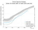
??? Are you trolling?It would be foolish to pretend that the lack of polar ice is not having an effect on cold air transport.
 usicecenter.gov
That’s a likeable trendShe's steady.View attachment 180705
Don’t know if this has been posted yet, if it has I apologize.
BamWx-
Sent from my iPhone using Tapatalk