Windergawx
Member

I’ve been living in Jasper now for about 4 years. Prior to that lived in Carrollton. Good point on CAD here in Pickens. Mt. Oglethorpe is to the NE of Jasper in NE Pickens Co. Mt. Oglethorpe is nearly 3,300 ft. I am about 1,400 ft in Jasper. Many setups like this will leave Pickens out of advisory but will have neighboring Dawson Co. in.Interesting numbers so far ahead of this system. Here is someone's station in northern Cherokee County, SC.
36/27
View attachment 140123
__________________________________________
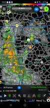
Burnt and Oglethorpe Mountains are where CAD is stopped in Georgia, due north of Atlanta. Stations on the top are reporting 32.7/24.6, in which Pickens County is not included in FFC's advisory.
View attachment 140124


My gutters are telling me this was a waisted opportunity. Pouring rain outside. So hard it woke me up out of a snow dream
Same here, currently 32.5 with avg wind of 12 mph nne. BrutalI bottomed out at 32.8/32. That is painful as you can get
Is this from RadarScope or if different, what app?Man that could’ve been fun View attachment 140164
I am sure UHI in not helping.Pretty sure it’s above 32 here, can’t even do ice right
Always sucks, ready to be in Blacksburg for a snowstorm that’s forsure.I am sure UHI in not helping.
It's raining all the way up to Frederick County. Even Garrett County MD is not snow right now. Amazing how easily we fail.Always sucks, ready to be in Blacksburg for a snowstorm that’s forsure.