-
Hello, please take a minute to check out our awesome content, contributed by the wonderful members of our community. We hope you'll add your own thoughts and opinions by making a free account!
You are using an out of date browser. It may not display this or other websites correctly.
You should upgrade or use an alternative browser.
You should upgrade or use an alternative browser.
Wintry January 29th-30th ARCC Slam Dunk Winter Weather Threat
- Thread starter ForsythSnow
- Start date
WXinCanton
Member
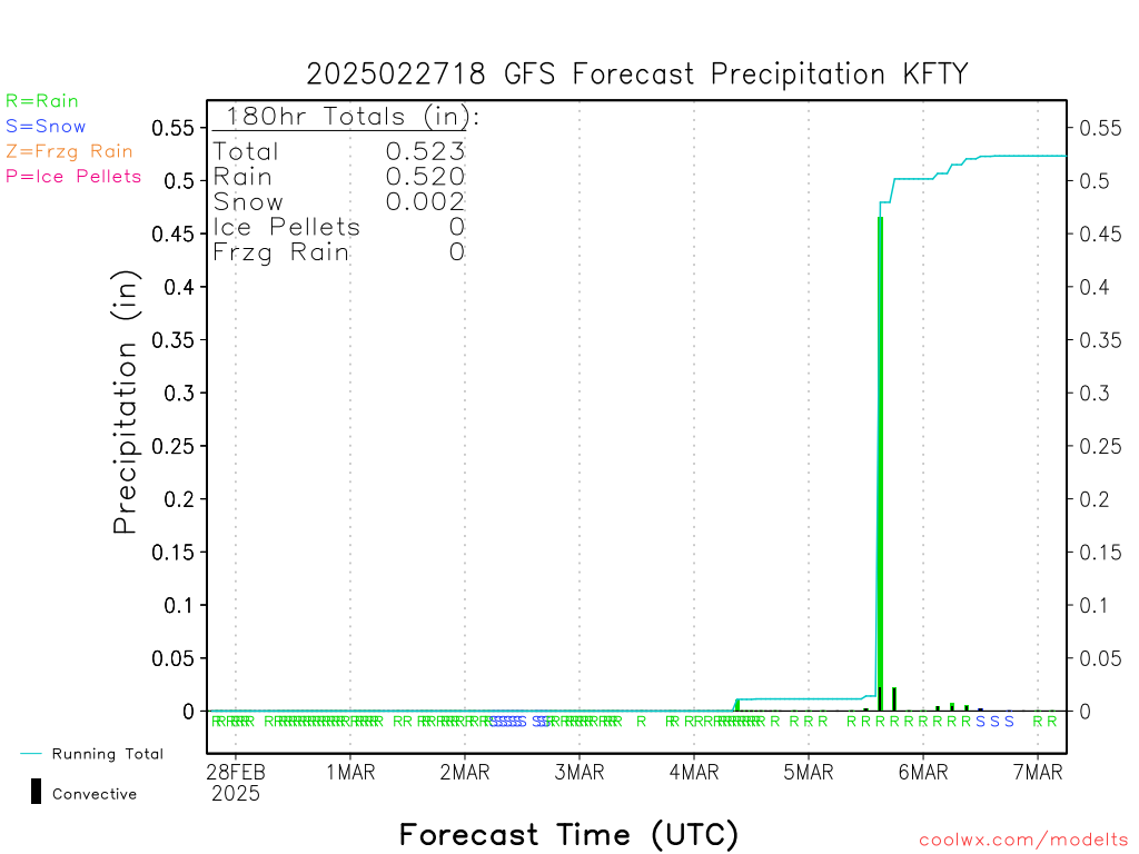
Text data from 12z GFS This is from Charlie Brown airport.
Friendly reminder.....Thats showing green because there isn't enough moisture in the snow growth region to actually snow. it comes down as some drizzle/light rain. yes it will freeze on contact with temps below freezing.look how screwed up the euro is..that isn't rain on the back side...can't believe a thing it shows
View attachment 14080
Philstorm91
Member
That happened here in Baton Rouge during the storm system on 1/17/18. Rain changing to snow by 4pm, but moisture got scoured out by 8pm. Result was it was just tiny ice pellets near the end.Friendly reminder.....Thats showing green because there isn't enough moisture in the snow growth region to actually snow. it comes down as some drizzle/light rain. yes it will freeze on contact with temps below freezing.
Sent from my SM-G950U using Tapatalk
Text data from 12z GFS This is from Charlie Brown airport.
Let’s hope Lucy is not giving false hope to Charlie Brown airport.
Not to rain on anyone's parade wrt the GFS & GEFS but...
I think I'm gonna start saying, "oh look there is pony" every time one of those maps are posted.
Shouldn't it show it in pink then? I have never heard of this until now.Friendly reminder.....Thats showing green because there isn't enough moisture in the snow growth region to actually snow. it comes down as some drizzle/light rain. yes it will freeze on contact with temps below freezing.
Some do and some don’t.Shouldn't it show it in pink then? I have never heard of this until now.

look how screwed up the euro is..that isn't rain on the back side...can't believe a thing it shows
View attachment 14080
OK one more time. That isn't rain on the back side. In fact it isn't anything on the back side. That is an 6 hour QPF map with precip determined by the temp taken at the time the image was produced.
And
Oh look a pony.
Snowflowxxl
Member
Atlanta now in a WWA. Northern counties in a WSW
look how screwed up the euro is..that isn't rain on the back side...can't believe a thing it shows
View attachment 14080
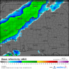
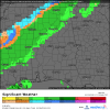
Just to quote this post again. That above is a QPF map, the one below is simulated radar and radar with precip type overlay.
Attachments
Flurry
Member
Definitely juicing up...
RollTide18
Member
Euro gives MGM 1/2 inch, I’ll take that all day everyday.
Fountainguy97
Member
Euro gives MGM 1/2 inch, I’ll take that all day everyday.
A lot of areas look good to see 1-3 hrs of light/mod snow falling.
Definitely a huge win for a lot of areas! Enjoy it guys!
LovingGulfLows
Member
- Joined
- Jan 5, 2017
- Messages
- 1,291
- Reaction score
- 3,251


Euro gives MGM 1/2 inch, I’ll take that all day everyday.
Euro is two to three inches here. If that happens I'll be pleasantly surprised.
Fountainguy97
Member
You can see the system shaping up nicely now.
The front is easily visible and looks healthy. You can easily make out the energy down in the GOM that will enhance the band across Mississippi/Alabama.
It’s time to now cast guys! Radar is lighting up in a few hrs! Enjoy the ride and don’t let the frustration of “it could be more” ruin a nice little snow tomorrow!
RollTide18
Member
Euro is two to three inches here. If that happens I'll be pleasantly surprised.
Same, looking at the correct rain/snow map, it seems to give a nice 90 minutes of snow/slush.
It would have to be more than light/mod snow to accumulate 2-3" in a 2-3 hour time frame wouldnt it ?A lot of areas look good to see 1-3 hrs of light/mod snow falling.
Definitely a huge win for a lot of areas! Enjoy it guys!