• Hello, please take a minute to check out our awesome content, contributed by the wonderful members of our community. We hope you'll add your own thoughts and opinions by making a free account!

Wintry January 23rd-27th 2026

I remember that the modeling that was showing storms firing along the western Gulf were sending less moisture to western areas and more to the east
Yes, I believe those storms provide the moisture and some lift for our first batch of precip over night. Without them qpf totals were less in the midnight-4am time frame.

Also, side point, the nam was wrong when it tried to not show any convection there. Euro/gfs/rgem/icon were right about the convection.
 
weren’t people saying that if thunderstorms fired up towards gulf like some models had it, it showed a lot more moisture south? I can see storms popping off by Houston. Curious
It depends on how they align. If they are perpendicular, they can sometimes enhance moisture. If they were like a straight line across the gulf, it can cut them off. A professional can fact check me but thats how I remember it going.
 
Yes, I believe those storms provide the moisture and some lift for our first batch of precip over night. Without them qpf totals were less in the midnight-4am time frame.

Also, side point, the nam was wrong when it tried to not show any convection there. Euro/gfs/rgem/icon were right about the convection.
Yes and interestingly those were the colder models that kept precip as sleet longer.
 
My loose benchmark for the I-85 corridor in Upstate SC is that if we are still sleeting past 7-8AM tomorrow we will have made a good dent in the ZR potential. If we flip to ZR before 2-4AM I think we are in deep ----. Still think even when sleet profiles are present we may have frz drizzle mixed in. Erosion Sunday night will be a big deal and if we do not get above freezing here we probably stay frz rain/drizzle/mist from at least 6AM Sunday to midnight Monday morning or so. Latest HRRR keeps me <32F at sfc with drizzle till 1AM or so monday
 
My loose benchmark for the I-85 corridor in Upstate SC is that if we are still sleeting past 7-8AM tomorrow we will have made a good dent in the ZR potential. If we flip to ZR before 2-4AM I think we are in deep ----. Still think even when sleet profiles are present we may have frz drizzle mixed in. Erosion Sunday night will be a big deal and if we do not get above freezing here we probably stay frz rain/drizzle/mist from at least 6AM Sunday to midnight Monday morning or so. Latest HRRR keeps me <32F at sfc with drizzle till 1AM or so monday
From what I’ve read, and this jives with my 2015 experience. Small water droplets/drizzle will easily be sleet for us. Heavier batches and burst of moderate precip will fall as rain.

As such, I expect predominately light sleet most of the night with a periodic freezing rain mix during heavier batches.

It’s going to fun to watch it unfold either way.
 
It depends on how they align. If they are perpendicular, they can sometimes enhance moisture. If they were like a straight line across the gulf, it can cut them off. A professional can fact check me but thats how I remember it going.
Correct, unless that perpendicular line of storms races out ahead of the system then it can have same impact as an east to west line of storms. Don't think it will play a huge role in this system, just my humble opinion though
 
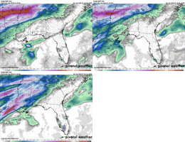
I mean, this is only 18 hours out, over the last 3 runs! Crazy. View attachment 188457
My opinion here is that this is a really large storm with big features, where the globals should shine more in terms of precipitation output. NAM is going to be on the schizophrenic side with how it pops out precip
 
It depends on how they align. If they are perpendicular, they can sometimes enhance moisture. If they were like a straight line across the gulf, it can cut them off. A professional can fact check me but thats how I remember it going.

Correct, Matt East used to talk about this in his “Carolina Weather Video” if it’s going with the storm orientation ( / ) then it opens the firehouse ….. If it goes against it ( \ ) and way out in front it will rob it


Sent from my iPhone using Tapatalk
 
Last five RDU QPF outputs focused on 18z tomorrow:

.32 .88 .41 .72 .53

Kermit The Frog No GIF by Muppet Wiki
 
Looks to me like high pressure has built in a little faster and farther south than what the models had showed. Would imply stronger wedge and colder surface temps for tonight/tomorrow. That meso-high over Virginia is a warning shot that this thing is gonna be on the cold side of guidance in the low levels/surface, my two cents.
Wouldn't that lean towards more sleet
 
From what I’ve read, and this jives with my 2015 experience. Small water droplets/drizzle will easily be sleet for us. Heavier batches and burst of moderate precip will fall as rain.

As such, I expect predominately light sleet most of the night with a periodic freezing rain mix during heavier batches.

It’s going to fun to watch it unfold either way.
While we are sitting at -7 to -10 925’s yes. We don’t stay at those temps very long. Those quickly turn into -1 to -5. That’s cold enough to stop a deeper warm nose with 850’s at +8 to +11
 
Atl Mets backing off the strength of the CAD this morning
I can certainly see, based on some of the overnight modeling, why that is. I told my family this morning, even here, that the odds of some of the high-end totals have gone down. That said, underestimating CAD here usually doesn't work out well. So, it's surrounding obs and radar from here for me.
 
The NAM is so trash man. It’s self correcting wetter west to east each run. It’s still likely too warm at the surface as others out west are pointing out. And the CAD appears to be stronger out ahead (shocker). The HRRR and RGEM don’t get me above 28 degrees at any point in the storm. That makes way more sense to me
 
“No significant changes” as if half the counties in the Ice Storm Warning don’t get ZERO from that. No wonder the public has no trust.
Cobb now has a little slice of pink, a couple of hours ago all of Cobb was leaning purple. Just tell us the models are all over the place and hard storm to forecast, don’t try to rewrite history😑
 
Back
Top