• Hello, please take a minute to check out our awesome content, contributed by the wonderful members of our community. We hope you'll add your own thoughts and opinions by making a free account!

Wintry January 23rd-27th 2026

You think it’s going to change that much by tonight. But I get it…you just like to be argumentative.

Maybe you like the GEFS better 😂

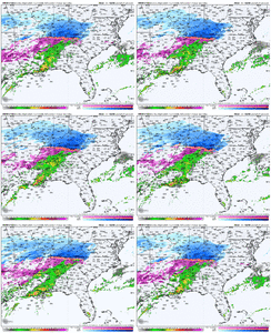
The big 3…


View attachment 188433View attachment 188434View attachment 188435

No I don’t like to be argumentative. I like to verify my forecast when something has actually happened already, not beforehand like you always seem to do, including for the storm last weekend 🙄

It’s a cad event, do I really expect a coarse gridded or any model to properly be able to resolve/handle the sort of forcing (a very shallow cad dome with moist upglide over it). that’s going to generate my precip and further be able to delineate the details here? Probably not.
 
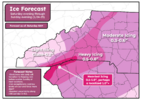
Might do 1 final call map this morning. Prelim thought right now are:
DT Greenville - 0.5-0.75”
GSP - 0.6-0.75”
DT Spartanburg - 0.65”-0.8”
Anderson/greater Oconee, greater Pickens - 0.4-0.6”
Gaffney - 0.5-0.75”
Travelers Rest to Inman to Boiling Springs - 0.7-0.9”
Along Highway 11 and north from Spartanburg county through Greenville mountains, Pickens mountains, and Oconee mountains - 0.8-1”+

Along and east of Highway 25 in Greenville county and along and north of I85 likely could also get 1-3” of sleet. 0.5-2” of sleet west of Highway 25.
Im 20 miles North of the state line in Rutherford. I would assume the higher end of your thoughts for Gaffney + most IP.
 
Paulding County Airport is 32 degrees with a 6mph NE wind and cloudy as crap warm air gonna have a fight on its hand I don't believe we will even get close to our 44 forecasted high here today. CAD maybe just getting started
 
It’s got a dry air/low dew point bias and is always too cold in cad set ups from what I’ve noticed. Still fun to look at though. And maybe shows the 5% extrem solution of the cold press verified on the extreme end of things.
Yeh the cold air seems extreme on it. Honestly it was the moisture part of it that surprised me. But anyways, good to know.
 
As usual you are being your typical pompous self. Kind of sad, feel sorry for you.

I was simply looking at it from which global had the general idea/location from a week out. Nothing more. And you repeatedly attack me. I get it…you’re weak and insecure and you come on here to alleviate that. Now just leave me alone and I will leave you alone. Better yet…just block me and you won’t have to read my posts, but I know you won’t.

My original post wasnt attacking anyone, was just my opinion on which global handle this better a week out.

I like to verify forecasts after something has happened not beforehand, it’s called doing good science. Pretending like you have all the answers already beforehand based on a short term model forecast is just being arrogant.

Do those general ideas matter here? Yeah, but so do the details, and they matter a lot in a setup like this. If this precip axis shifts 1-2 rows of counties north or south, no one here is going to give a crap what model forecast showed “x” or “y” because it will significantly or even dramatically change the sensible impacts in their backyard. That’s why I’d like to verify the forecast first before we claim what model performed better etc

IMG_7516.png


Pompous? You mean just like the last storm when you personally attacked me for not going with/buying the NAM during the last storm a day out which snowed a lot of snow at your house, only for it to completely fold at the 0 hour? Yeah ok 😂
 
Eh. I’m not convinced ATL proper sees anything wintry honestly. It seems like we stay right above 32 ITP.

These Atlanta TV METS are gonna catch hell. Lol. Not their fault though, craziest storm I’ve ever tracked. I think they overplayed their hand on this one and have maintained that overplay and it may backfire.

We shall see though. It seems models aren’t really sure what’s going to happen…but getting to almost 50 later today sure seems to limit how bad it can get later tonight.


Sent from my iPhone using Tapatalk
 
I’m near Nashville & all the radar maps show significant snow showers right on top of me but it’s bone dry outside my window. Is this the dry air monster eating my snow?
It is but there is really nice push of precipitation moving in, give it 45 minutes and come back and see if you have snow falling.
 
I want to give a couple disclaimers quickly. I have not focused as much on central NC and have lower confidence in that area. It wouldn't shock me if the northern Foothills found a way to sleet longer and didn't make it to 0.3", but they just as easily can exceed that. I have not focused as much on GA or Raleigh or eastern NC/SC and do not want to provide a forecast that may be ill-informed. That said, here is my take on the ZR potential today into tomorrow for primarily western NC and SC:

Screenshot 2026-01-24 081212.png

I would consider this an abnormally low confidence forecast. There will be more valley/peak variance in NC than this map indicates but I didn't get into the weeds on that. Generally expect lower accretion in interior WNC valleys, especially further south.

It would not surprise me if the Upstate got more like a general half inch, but the upper range of my forecast is absolutely doable.

As for sleet, low confidence, but generally expecting an inch or so along I-85, 1-2" north TO I-40, and 2-3" north OF I-40. Let's hope that low level cold wins out and "all" we manage is 0.3-0.5".
 
Can we at least wait until after the storm has occurred to argue about who, what was right? Please don't clutter this thread, now of all days. A very serious situation for some may be unfolding and people have to weed through this nonsense, it can wait guys. Thanks
 
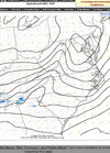
Can you explain what this is showing?


Sent from my iPhone using Tapatalk
Looks to me like high pressure has built in a little faster and farther south than what the models had showed. Would imply stronger wedge and colder surface temps for tonight/tomorrow. That meso-high over Virginia is a warning shot that this thing is gonna be on the cold side of guidance in the low levels/surface, my two cents.
 
Looks to me like high pressure has built in a little faster and farther south than what the models had showed. Would imply stronger wedge and colder surface temps for tonight/tomorrow. That meso-high over Virginia is a warning shot that this thing is gonna be on the cold side of guidance in the low levels/surface, my two cents.

Thanks for the info. I appreciate it.


Sent from my iPhone using Tapatalk
 
Looks to me like high pressure has built in a little faster and farther south than what the models had showed. Would imply stronger wedge and colder surface temps for tonight/tomorrow. That meso-high over Virginia is a warning shot that this thing is gonna be on the cold side of guidance in the low levels/surface, my two cents.
Agreed and that mesohigh could also keep a lot sleet longer for some areas like we saw in February 2015
 
Frozen mist or drizzle will have a lot easier time accruing at 31/32 than heavier precip. I’ve said it before but even during “lulls” tonight, it will continue to add up.

We won’t know specifics till we see how the wedge performs
So far no sign of any wedge yet. Winds have shifted to the northeast and brought the lower 40s just like the models predicted.
 
Eh. I’m not convinced ATL proper sees anything wintry honestly. It seems like we stay right above 32 ITP.

These Atlanta TV METS are gonna catch hell. Lol. Not their fault though, craziest storm I’ve ever tracked. I think they overplayed their hand on this one and have maintained that overplay and it may backfire.

We shall see though. It seems models aren’t really sure what’s going to happen…but getting to almost 50 later today sure seems to limit how bad it can get later tonight.


Sent from my iPhone using Tapatalk
I'm convinced the guy who shared the 2-cycle old GFS snow map earlier this week wasn't doing so out of his own preference and was likely told to share it, becuase it looked the most sensationalist and would get more viewers watching advertisements
 
weren’t people saying that if thunderstorms fired up towards gulf like some models had it, it showed a lot more moisture south? I can see storms popping off by Houston. Curious
I remember that the modeling that was showing storms firing along the western Gulf were sending less moisture to western areas and more to the east
 
weren’t people saying that if thunderstorms fired up towards gulf like some models had it, it showed a lot more moisture south? I can see storms popping off by Houston. Curious
From what I gathered, and someone please correct me, but if there are storms to the south then it robs moisture up north. But if you are upstream, that is a good look for you as it pertains to QPF being higher
 
Back
Top