NCHighCountryWX
Member
- Joined
- Dec 28, 2016
- Messages
- 699
- Reaction score
- 1,918
See the new WPC morning update. Implies sleet over all of NC with icing risks in SC
The idea of a quickly eroding CAD wedge isn’t so far fetched given the synoptics (rapidly retreating 50/50, NE high, etc.) and I’m sure Google’s model lives up to its statistical superiority but I personally don’t buy it retreating THAT quickly. As rain cold pointed out would be nice to see where the fgen sets up on this modelOther thing is, my god, this ain't work, have a little fun in here
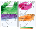
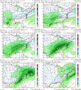
The Google DeepMind, Google Research, Weathernext Ensemble 06z run was a small tick south with storm track / mid-level temperatures. Surface temperatures stayed the same in the cold wedge
Here are surface temperatures from the 06z run and total storm precipitation 9-run trend
View attachment 187472
View attachment 187473
can you post it?See the new WPC morning update. Implies sleet over all of NC with icing risks in SC
here is there discussion. do not hear this from them very often.can you post it?
This has been my thought process for several days. I’ve lived in Atlanta my entire life (33yrs) and I literally cannot think of a situation similar to this where we had a strong CAD anchor itself into the metro area and break down this easily. Even the January 2005 ice storm I alluded to a couple days back I believe only had a HP around 1028mb or so over NY state during the height of the storm (wish I could find that surface map I saw from yrs back). We’re talking about an anchored HP across the NE region around 1040mb, possibly stronger, constantly feeding in arctic cold, dry air damming down the backside of the Appalachians. Past, lived experience has shown me the ending to this movie too many times. I’m not fully convinced an escape hatch is coming for Atlanta and points NE in GA yet.I think we need to be flexible here. If the Euro is right and it retreats the northern high pressure zone too quickly and runs the primary low up into Charleston, WV and the secondary forms off of the coast of NJ, then yes, we will dry slot and the warmer temperature scenario will play out.
However, if the cold air hangs in longer than the model realizes (which we have seen countless times in these scenarios), then the primary low WILL NOT got up to Charleston, WV. It may, in fact, trend toward not getting past northern AL and the primary reforms off of Myrtle Beach, and the much colder solutions verify. There will still be a dry slot in there, but it may be less so.
If you take a look at the animation of the Euro both the snow and freezing rain accumulation maps, you will clearly see that the north trend has ceased, and the latest run ticked south on both. If that continues, then the warmer solution is off the table, and we'll see about QPF.
The office in Atlanta is considering expanding the winter storm watch south. They see what is going on.
This is not insitu damming. It is classic, and the high pressure, from almost all guidance will supply very cold and dry air at the surface through the bulk of the storm.
For the life of me I don’t see why the northern midlands counties don’t have watches yet.here is there discussion. do not hear this from them very often.
Heavy icing is also likely into the TN Valley and nearby southern
Appalachians and Mid- Atlantic, where freezing rain continues
beyond the D3 timeframe. The setup across the southern Mid-Atlantic
down as far south as northern GA and areas just inland from the
coasts of the Carolinas is an extreme case of CAD with a 1040mb
high situated over the Interior Northeast on Saturday night. This
high pressure filters very low/dry dew points with values below
zero prior to precip onset late Saturday. This cold air wedge
remains sharply locked in place at the surface for the remainder
of the event as 700-850mb temperatures begin to increase well above
freezing by the end of D3 throughout the Carolinas and northern
GA. WPC probabilities for >0.25" of freezing rain accretion through
12z Sun. are currently 40-70% from northern AL/TN through northern
GA and into the Midlands of SC and areas just inland of the NC
Tidewater region. Heavy sleet accumulations are also possible where
the low-level column remains colder into VA Piedmont.
Nah. Part of the programming is topography. For KATL. The difference between 29-30 degrees and 31-32 degrees is huge. All else being equal, CAD is usually underdone by models. So under 30 degrees, there is certainly on the table. ICON/GFS remains below for most of the storm. EURO 6 hours or so. It's going to be close for ATL. The NE burbs are likely in trouble, though.Question: do you think the EURO is going off of climo? Noticed how it is tightening up around CAD favored areas for ice.
Its a tough call. My gut says similar to you that northwest of 85 will have enough sleet to save from the most widespread power outages, and personally think the interior wedge zones of GSO/HKY/Wilkes will indeed avoid the max ZR. Warm noses can punch above their weight a little bit and in this case that may shift the sleet line further north than I would draw it right now. Could see some extra ZR in far western Upstate as well with less wedging there in Oconee and Anderson. This doesn't look entirely unreasonable to me as far as the ptype corridors, perhaps they are a bit too far south and would be trimmed back some on the wedge exterior:Thank you to everyone reasonable here trying to post sensible solutions.
Next,
I'm 55 lived here in Taylors, Greer, Paris Mnt area my entire life.
Always been a weather nerd!
It's been my experience in strong CAD situations that it's generally under modeled till go time! (See 2002 & 2005)
Areas closest to the Eastern mountain ranges hold onto the wedge the longest and the edges lose it the quickest,
Esp those closer to the the Atlantic.
Places like Hickory & GSP hold that cold air till the very end.
I'm hoping that the models are under doing the cold and that we stay sleet longer,
Which I think may happen from a line of GSP or just SW of their NW thru the Western Piedmont & foothills of NC.
The dividing line is generally 85.
NW of the sleet line holds onto the sleet longer the further SE from their you go the sleet changes to FrRn faster.
It's going to be disaster in a large chuck of NGA thru the Carolinas.
I'm hoping we all can get more sleet to save us from extensive power outages!
Thoughts from you or anyone that can be reasonable on where that sleet line sets up saving a good portion of the area catastrophic FrRn numbers.
Please include the entire NGA & Carolinas,
Not just NC!
Once again TY to everyone!

In fairness, the wedge is quite cold on the Weathernext and it holds thru the full storm for the most part for NC and down into the upstate, but breaking down as the precip is moving out....but that's probably wrong as it likely won't scour out at the end with it so moistThe idea of a quickly eroding CAD wedge isn’t so far fetched given the synoptics (rapidly retreating 50/50, NE high, etc.) and I’m sure Google’s model lives up to its statistical superiority but I personally don’t buy it retreating THAT quickly. As rain cold pointed out would be nice to see where the fgen sets up on this model

I am ground zero based on that observation.It’s all but over in the upstate. The heaviest QPF and coldest surface temps are situated from Highway 74 in NC South to around Laurens and Greenwood
My fear is something like what the Euro and NAM had prior with the squall line. Straight from 30 hours of ZR to a squall line would completely decimate the power grid and trees. Hoping the cooler trends coming in get us some more sleet instead of ZRI've been so focused on p-type corridors and QPF that I forgot we have a stout cold front coming in Sunday night. Damage done on Sunday from ZR weight alone may only be the half of it as winds pick up overnight into Monday
Can you give me the direct link where I can find that here. So much info on this site.See the new WPC morning update. Implies sleet over all of NC with icing risks in SC
I see winter storm watches down to the Newberry/Lexington border unless I’m seeing mirages.For the life of me I don’t see why the northern midlands counties don’t have watches yet.
Might be banter but it seems like it is going back to square one.
Here’s your upstate wedge boundary. This is the way radar goes around here 99.9% of the time. If you are anywhere in the snow on this old radar image, oofThank you to everyone reasonable here trying to post sensible solutions.
Next,
I'm 55 lived here in Taylors, Greer, Paris Mnt area my entire life.
Always been a weather nerd!
It's been my experience in strong CAD situations that it's generally under modeled till go time! (See 2002 & 2005)
Areas closest to the Eastern mountain ranges hold onto the wedge the longest and the edges lose it the quickest,
Esp those closer to the the Atlantic.
Places like Hickory & GSP hold that cold air till the very end.
I'm hoping that the models are under doing the cold and that we stay sleet longer,
Which I think may happen from a line of GSP or just SW of their NW thru the Western Piedmont & foothills of NC.
The dividing line is generally 85.
NW of the sleet line holds onto the sleet longer the further SE from their you go the sleet changes to FrRn faster.
It's going to be disaster in a large chuck of NGA thru the Carolinas.
I'm hoping we all can get more sleet to save us from extensive power outages!
Thoughts from you or anyone that can be reasonable on where that sleet line sets up saving a good portion of the area catastrophic FrRn numbers.
Please include the entire NGA & Carolinas,
Not just NC!
Once again TY to everyone!

NC declared one yesterday.Hey gang
Any ideas if we will start seeing state of emergency declared anytime soon? Hope we are all safe and well during this event and keeping front line people in our thoughts and prayers
I was about to type the same thing. In my 40+ years living here I've never seen an ice storm change back to plain rain. The weathermen in the first 2000 ice storm said all day that Saturday that it would warm up. Glenn Burns finally came on late in the afternoon and conceded that they were wrong. This may be the one to buck the trend but with every other wedge that made it through Atlanta they've never broken down.This has been my thought process for several days. I’ve lived in Atlanta my entire life (33yrs) and I literally cannot think of a situation similar to this where we had a strong CAD anchor itself into the metro area and break down this easily. Even the January 2005 ice storm I alluded to a couple days back I believe only had a HP around 1028mb or so over NY state during the height of the storm (wish I could find that surface map I saw from yrs back). We’re talking about an anchored HP across the NE region around 1040mb, possibly stronger, constantly feeding in arctic cold, dry air damming down the backside of the Appalachians. Past, lived experience has shown me the ending to this movie too many times. I’m not fully convinced an escape hatch is coming for Atlanta and points NE in GA yet.
That was a well put together analysis of what the models are currently showing and very easy to read. So from what I am getting the ideal situation would be that if the GFS is right about colder temperatures and more sleet and the Euro suite is correct about a dry slot limiting QPF amounts. One thing is certain, there is still a lot that can change with more than 48 hours before we start feeling the effects from this storm.Time to start working specifics this morning. I'm going to have a western Carolinas slant per usual as that is where I live and forecast for. Consider this table for the I-85 corridor in Upstate SC - Charlotte, following I-77 north, and all of NC north/west of that boundary.
Model Precip Onset Time Duration QPF P-Type Notes Recent Trend Notes Overall ECMWF (06z 1/22) 03z-06z Sunday ~24 hours w/ some rain at the very end late Sun night 1.5" to 3", with a general 1.7-2.0" for most. Not a huge amount of change recently in this but perhaps some dry slots could work in? Verbatim, entirely ZR but ECMWF known to not model sleet well. Think a good chunk of NC Piedmont would have notable sleet Has been eroding the wedge for Upstate/CLT to peek above 0C Sunday night, but its close enough that this could easily be wrong. Damage likely done by then anyways. Likley underestimating sleet but this slightly further north solution vs GFS could bring more ZR into the region. The accum ZR maps from it are overdone. 850s are actually subzero C for a decent amount of time in NW NC (till 18z) GFS (06z 1/22) 21z Sat-00z Sun ~30 hours w/ perhaps a brief changeover to drizzle at the end 1.6" to 3", w/ general 1.9"-2.2". Wettest in far western NC/SC Mostly sleet. A flip to ZR for the last few hours puts a notable layer of ice down at the end Has been ticking north some but not a huge amount. Really pretty similar to ECMWF locally. Could bring an opportunity to hang on to sleet/snow for a bit longer with heavier precip. CMC (00z 1/22) 15z-21z Sunday ~30 hours, no change to rain 1.3" to 3"+, w/ 2"+ for much of NC FH. Dry slot noted to south but has been trending south Roughly half the event sleet/half ZR, depending on wedge depth. Southern/western Upstate much icier. Feel the ZR map from this one is not unreasonable at the moment for this region. Pretty steady. Moving dry slot further south. Similar to GFS. Tons of sleet. Think it probably has a better idea of wedge endurance locally. EC AIFS (06z 1/22) 03z-06z Sunday ~24 hours with no change to rain except perhaps far western/southern upstate and western mountains 1.0" to 1.5", driest model we have at this juncture. Trending a hair drier as well Quickly erodes 850 0C layer so that whole event is ZR for most aside from core wedge zones in NC FH. May actually be worse since ZR accrual would be more efficient in a lighter precip scenario Trending a bit drier and a hair warmer but not enough warm not make a difference for most. QPF trend bears watching. Think it is possible it is underdoing it some but the ENS is a smidge drier as well. Again this may be a worse scenario with lighter precip/still enough to cause issues.
Notes on other models: EPS trending wetter in general. Haven't looked at WeatherNext but assuming similar trend to AIFS as it tends to mirror that model. Not putting much stock in NAM/RGEM quite yet but note that RGEM is absolutely headed for impactful ZR along I-85 with heaps of sleet in NC FH
I agree with you, in all my years regardless of whether the CAD had us below freezing or not, I've never seen the low come this far north and dislodge the cold air at the surface. The Euro tries to do that Sunday, we shall see.I was about to type the same thing. In my 40+ years living here I've never seen an ice storm change back to plain rain. The weathermen in the first 2000 ice storm said all day that Saturday that it would warm up. Glenn Burns finally came on late in the afternoon and conceded that they were wrong. This may be the one to buck the trend but with every other wedge that made it through Atlanta they've never broken down.
That Carolina Blue streak runs through the most densely populated part of North Carolina. That's not very encouraging so emphasis should be on getting ready for what might happen and praying that the colder and more southern trends on the models continue today.
That ZR graphic will be referenced a lot. Those winds can make a level 2 storm into a level 4 stormI've been so focused on p-type corridors and QPF that I forgot we have a stout cold front coming in Sunday night. Damage done on Sunday from ZR weight alone may only be the half of it as winds pick up overnight into Monday
