It makes sense…overrunning misses to our north and miller b dryslot. It happens.Every ounce of me hopes this is close to reality. I hope this is like one of those summer events where we are hoping for drought relief but just end up not getting as much precipitation as advertised. It can happen.
-
Hello, please take a minute to check out our awesome content, contributed by the wonderful members of our community. We hope you'll add your own thoughts and opinions by making a free account!
You are using an out of date browser. It may not display this or other websites correctly.
You should upgrade or use an alternative browser.
You should upgrade or use an alternative browser.
Wintry January 23rd-27th 2026
- Thread starter SD
- Start date
TigerSnow
Member
This can truly be the case. Let’s ask ourselves this right now. How many models are showing it too warm and super light? Is it just the euro right now? Others can trend that way but I would rather be prepared.Every ounce of me hopes this is close to reality. I hope this is like one of those summer events where we are hoping for drought relief but just end up not getting as much precipitation as advertised. It can happen.
WolfpackHomer91
Member
Move to banter if necessary (Not sure)
I’ve been model watching for 18yrs in this area since Allenhuffman.com or w/e …. Some things of note as we move inside 36-48hrs that I’ve noticed over the years of lurking that I take as gospel.
1. In CAD If NAM/RGEM start showing some insane Warm Nose ….. Accept Defeat and don’t fight it.
2. Blend QPF of the 3 major Globals and avg
3. NEVER be deceived or seduced by the HRRR
4. Take the most Northern Track and the most Southern …. Split it that’s your answer.
5. Know your historical Climatology (If you’re in say SE Stanly county NC or Dillon SC a see models showing Numbers you’ve never seen in a wedge…. Don’t believe it.
6. Have fun, enjoy it…. We don’t get as many of these as we used to
Sent from my iPhone using Tapatalk
I think we need to be flexible here. If the Euro is right and it retreats the northern high pressure zone too quickly and runs the primary low up into Charleston, WV and the secondary forms off of the coast of NJ, then yes, we will dry slot and the warmer temperature scenario will play out.
However, if the cold air hangs in longer than the model realizes (which we have seen countless times in these scenarios), then the primary low WILL NOT got up to Charleston, WV. It may, in fact, trend toward not getting past northern AL and the primary reforms off of Myrtle Beach, and the much colder solutions verify. There will still be a dry slot in there, but it may be less so.
If you take a look at the animation of the Euro both the snow and freezing rain accumulation maps, you will clearly see that the north trend has ceased, and the latest run ticked south on both. If that continues, then the warmer solution is off the table, and we'll see about QPF.
The office in Atlanta is considering expanding the winter storm watch south. They see what is going on.
This is not insitu damming. It is classic, and the high pressure, from almost all guidance will supply very cold and dry air at the surface through the bulk of the storm.
Yep very confusing and annoying when people that don’t know what they are seeing try to post play by play10 posters say the Euro trended south and colder and 1 poster(edit: make that 2 posters) says the Euro trended warmer and drier and to nothing.
I'm not sure what's going on this morning.
You gonna get 1.0-2.0 all frozen moisture. not getting out of the 20;s whole storm. Locked in. Pray its sleet more than freezing rain. I'd make sure you start thinking about the what if's with loss of power for several days. How it affects your heat source, water if your on well water etc. From NC down into upstate into NE GA. This is not something to ignore. If you can't sleet away some of these accums, It's gonna be lights out.Looks like we are trending drier and warmer
CNCsnwfan1210
Member
I think we need to be flexible here. If the Euro is right and it retreats the northern high pressure zone too quickly and runs the primary low up into Charleston, WV and the secondary forms off of the coast of NJ, then yes, we will dry slot and the warmer temperature scenario will play out.
However, if the cold air hangs in longer than the model realizes (which we have seen countless times in these scenarios), then the primary low WILL NOT got up to Charleston, WV. It may, in fact, trend toward not getting past northern AL and the primary reforms off of Myrtle Beach, and the much colder solutions verify. There will still be a dry slot in there, but it may be less so.
If you take a look at the animation of the Euro both the snow and freezing rain accumulation maps, you will clearly see that the north trend has ceased, and the latest run ticked south on both. If that continues, then the warmer solution is off the table, and we'll see about QPF.
The office in Atlanta is considering expanding the winter storm watch south. They see what is going on.
This is not insitu damming. It is classic, and the high pressure, from almost all guidance will supply very cold and dry air at the surface through the bulk of the storm.
I’m not sure if this even something worth mentioning, but the 6z Euro had a 1042 HP over Erie PA
Sent from my iPhone using Tapatalk
Hoping so as well but discouraged by the absolute minimum QPF on the 0z EPS being ~0.75” around here. In fact, the 0z was the wettest EPS run yet for the Upstate. The AIFS has been ticking QPF down but not wholly supported by its ENS at the moment.Every ounce of me hopes this is close to reality. I hope this is like one of those summer events where we are hoping for drought relief but just end up not getting as much precipitation as advertised. It can happen.
I-85 corridor in SC from the big boys as of 0/6z:
Euro 1.5-2”
GFS 2-3”
CMC 1.2”-1.7”
AIFS 1-1.5”
EPS 1.5”-2”
GEFS 1.5”-2.2”
AI EPS 1.2”-1.6”
This is just for Raleigh area…models are pushing the overrunning part of the event further NW…Euro/AI/NAM
This is when temps are at the coldest.

Then the final band swings through and on the Euro it flips Raleigh to rain. This isn’t trolling…just what’s happening on the models and in the realm of possibilities…realistic possibilities

This is when temps are at the coldest.
Then the final band swings through and on the Euro it flips Raleigh to rain. This isn’t trolling…just what’s happening on the models and in the realm of possibilities…realistic possibilities
Here's the Driest model out there ( Last nights 0z Euro), Not the 6z Nam, which only runs out 84 hrs and stops. Its the 0z Euro. This is a lot of qpf to anyone sitting below freezing the entire time. Every global out there is dumping close, if not 2.0 qpf fat stripes across NC.
Still 1.8 qpf. Aint gone be partial sun in the 40's , unless you way down in the coastal plain.

Still 1.8 qpf. Aint gone be partial sun in the 40's , unless you way down in the coastal plain.
Mpirone12
Member
This is just for Raleigh area…models are pushing the overrunning part of the event further NW…Euro/AI/NAM
This is when temps are at the coldest.
View attachment 187441
Then the final band swings through and on the Euro it flips Raleigh to rain. This isn’t trolling…just what’s happening on the models and in the realm of possibilities…realistic possibilities
View attachment 187445
Thanks for that! I know at least from a Greensboro perspective I’d honestly rather see an inch of QPF than over an inch and a half. There’s a point in this storm where I’m all for a good winter storm whether it be snow or a sleet/ some snow/and freezing rain but I’d rather stay out of the crippling criteria imo
Sent from my iPhone using Tapatalk
FWIW - not much most would say. JB says and has been saying for many days now, he thinks it rides up to Parkersburg, WV, and seconds off the Mid-Atlantic.I think we need to be flexible here. If the Euro is right and it retreats the northern high pressure zone too quickly and runs the primary low up into Charleston, WV and the secondary forms off of the coast of NJ, then yes, we will dry slot and the warmer temperature scenario will play out.
However, if the cold air hangs in longer than the model realizes (which we have seen countless times in these scenarios), then the primary low WILL NOT got up to Charleston, WV. It may, in fact, trend toward not getting past northern AL and the primary reforms off of Myrtle Beach, and the much colder solutions verify. There will still be a dry slot in there, but it may be less so.
If you take a look at the animation of the Euro both the snow and freezing rain accumulation maps, you will clearly see that the north trend has ceased, and the latest run ticked south on both. If that continues, then the warmer solution is off the table, and we'll see about QPF.
The office in Atlanta is considering expanding the winter storm watch south. They see what is going on.
This is not insitu damming. It is classic, and the high pressure, from almost all guidance will supply very cold and dry air at the surface through the bulk of the storm.
rburrel2
Member
09z sref…. Scary stuff. Way colder


Looks obvious to me. 


Brandon10
Member
While no one is fully expecting massive swings at this point, it's important to remember that we are still 72 hours out on the East Coast. And there still can be some significant changes surface wise based on small upper air tweaks.
However, if you were expecting snow in the south, we might need to turn our attention to next weekend.And also root against a northwest trend.
However, if you were expecting snow in the south, we might need to turn our attention to next weekend.And also root against a northwest trend.
So looks like our escape hatch for a major ice storm is decreasing, at least in the upstate of SC?Hoping so as well but discouraged by the absolute minimum QPF on the 0z EPS being ~0.75” around here. In fact, the 0z was the wettest EPS run yet for the Upstate. The AIFS has been ticking QPF down but not wholly supported by its ENS at the moment.
I-85 corridor in SC from the big boys as of 0/6z:
Euro 1.5-2”
GFS 2-3”
CMC 1.2”-1.7”
AIFS 1-1.5”
EPS 1.5”-2”
GEFS 1.5”-2.2”
AI EPS 1.2”-1.6”
rburrel2
Member
Our only escape hatch is the 925mb low level jet overperforming and keeping us sleet for 3/4 of the event.So looks like our escape hatch for a major ice storm is decreasing, at least in the upstate of SC?
Honestly, that outcome wouldn’t surprise me. But even if true, someone just south of that jet is still getting got.
iGRXY
Member
It’s all but over in the upstate. The heaviest QPF and coldest surface temps are situated from Highway 74 in NC South to around Laurens and GreenwoodSo looks like our escape hatch for a major ice storm is decreasing, at least in the upstate of SC?
IMO, and I’m sure it’s what local NWS field offices are doing, you got to look at what climo is telling up. As RainCold said this is a classic very strong CAD set up, not some weak in-situ wedge. Climo screams for low transfer further south down the coast as the stronger CAD is more locked inFWIW - not much most would say. JB says and has been saying for many days now, he thinks it rides up to Parkersburg, WV, and seconds off the Mid-Atlantic.
rburrel2
Member
Yes. Losing our last remaining escape hatch models to avoid a catastrophe is scary. We’re locking in the worst ice storm since 2005, and this one could be worse.“Scary”?
It’s specifically scary to me when I own 400 acres of timberland in Elbert county, Georgia. Thats loaded with 15-20 year old loblolly pines.
Makeitsnow
Member
If you look at dewpoints/wetbulbs across the modeling it's painfully obvious this wedge has a very cold bottom. It's frustrating you have modeling such as the euro that shows an unrealistic scouring of it and driving lows in unprecedented fashion straight into the heart of the wedge. My bet is against that because of common sense and it's physically impossible (and past history of every strong wedge ever). Also if you look closely, the euro is doing what it always does with large dewpoint depressions..it's underestimating the amount of evaparotional cooling. Looking closely it's at minimum 2 to 3 degrees too warm after saturation. So go ahead and feel comfortable subtracting that amount.
Last edited:
Time to start working specifics this morning. I'm going to have a western Carolinas slant per usual as that is where I live and forecast for. Consider this table for the I-85 corridor in Upstate SC - Charlotte, following I-77 north, and all of NC north/west of that boundary.
Notes on other models: EPS trending wetter in general. Haven't looked at WeatherNext but assuming similar trend to AIFS as it tends to mirror that model. Not putting much stock in NAM/RGEM quite yet but note that RGEM is absolutely headed for impactful ZR along I-85 with heaps of sleet in NC FH
| Model | Precip Onset Time | Duration | QPF | P-Type Notes | Recent Trend Notes | Overall |
| ECMWF (06z 1/22) | 03z-06z Sunday | ~24 hours w/ some rain at the very end late Sun night | 1.5" to 3", with a general 1.7-2.0" for most. Not a huge amount of change recently in this but perhaps some dry slots could work in? | Verbatim, entirely ZR but ECMWF known to not model sleet well. Think a good chunk of NC Piedmont would have notable sleet | Has been eroding the wedge for Upstate/CLT to peek above 0C Sunday night, but its close enough that this could easily be wrong. Damage likely done by then anyways. | Likley underestimating sleet but this slightly further north solution vs GFS could bring more ZR into the region. The accum ZR maps from it are overdone. 850s are actually subzero C for a decent amount of time in NW NC (till 18z) |
| GFS (06z 1/22) | 21z Sat-00z Sun | ~30 hours w/ perhaps a brief changeover to drizzle at the end | 1.6" to 3", w/ general 1.9"-2.2". Wettest in far western NC/SC | Mostly sleet. A flip to ZR for the last few hours puts a notable layer of ice down at the end | Has been ticking north some but not a huge amount. Really pretty similar to ECMWF locally. | Could bring an opportunity to hang on to sleet/snow for a bit longer with heavier precip. |
| CMC (00z 1/22) | 15z-21z Sunday | ~30 hours, no change to rain | 1.3" to 3"+, w/ 2"+ for much of NC FH. Dry slot noted to south but has been trending south | Roughly half the event sleet/half ZR, depending on wedge depth. Southern/western Upstate much icier. Feel the ZR map from this one is not unreasonable at the moment for this region. | Pretty steady. Moving dry slot further south. | Similar to GFS. Tons of sleet. Think it probably has a better idea of wedge endurance locally. |
| EC AIFS (06z 1/22) | 03z-06z Sunday | ~24 hours with no change to rain except perhaps far western/southern upstate and western mountains | 1.0" to 1.5", driest model we have at this juncture. Trending a hair drier as well | Quickly erodes 850 0C layer so that whole event is ZR for most aside from core wedge zones in NC FH. May actually be worse since ZR accrual would be more efficient in a lighter precip scenario | Trending a bit drier and a hair warmer but not enough warm not make a difference for most. | QPF trend bears watching. Think it is possible it is underdoing it some but the ENS is a smidge drier as well. Again this may be a worse scenario with lighter precip/still enough to cause issues. |
Notes on other models: EPS trending wetter in general. Haven't looked at WeatherNext but assuming similar trend to AIFS as it tends to mirror that model. Not putting much stock in NAM/RGEM quite yet but note that RGEM is absolutely headed for impactful ZR along I-85 with heaps of sleet in NC FH
mghjuno
Member
Any thoughts about the Nashville area? I’m seeing a lot of cut off maps that don’t go quite far west enough lol. Does it look like we are having a ‘94 style ice storm or a nuisance event?
beanskip
Member
Fountainguy97
Member
while the euro snow and ice maps haven't changed a ton the euro has steadily strengthened our cold air source and is putting more pressure on the storm. Another tick or two like this will pop that low over to the coast much quicker. Leading to a gfs solution.
Unfortunately, that just means more ice may be possible for southern regions.

Unfortunately, that just means more ice may be possible for southern regions.
packfan98
Moderator
We are all very hyper-focused on our backyards (and rightly so) at this point and it tends to cause some confusion when discussing model runs. Axis of heaviest precip, High Pressure placement, High pressure strength, mid-level temperatures, Low pressure track, and surface temperatures are going to adjust with each run. The High pressure strength can weaken, but the surface level temperature may come in lower. The low pressure may track further to the north, but the axis of heavy precip in the areas that are below freezing my not change much.
I say all of this because model run play by play might be confusing with seemingly conflicting information. My best suggestion is to learn to decipher the model maps yourself and focus on the good posters here that are closer to your local area. With an area this large, there's a ton of different indicators to try to decipher. Keep calm and be informed as best you can. Be safe everyone. Nothing wrong with being prepared.
I say all of this because model run play by play might be confusing with seemingly conflicting information. My best suggestion is to learn to decipher the model maps yourself and focus on the good posters here that are closer to your local area. With an area this large, there's a ton of different indicators to try to decipher. Keep calm and be informed as best you can. Be safe everyone. Nothing wrong with being prepared.
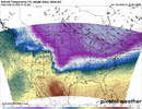
Webberweather53
Meteorologist
This is my first guess at freezing rain accumulations across the Carolinas.

At this point, I'm taking the euro as my lead model, but with the thought it is not calculating the strength of the CAD correctly (as Rain Cold stated). Today that will be my focus of how the models depict the CAD strength and where they transfer the low. But in all outcomes, many of us are looking at a bad ice storm. I started a prepping a few days back, but today is the big day to get things done.
NCWeatherNow
Member
My current thoughts on sleet/snow totals for the Piedmont.
Subject to change of course.

Subject to change of course.
It'll be interesting to see where the consensus hits in the coming hours regarding the qpf and wedge. I'm not sure it was approached 100% the correct way but the nam and euro trending the main fgen/waa precip north/lighter is a trend to watch for. That likely leaves the wedge more susceptible for erosion (wetter wedges hold better imo). If the wedge doesn't erode this is a massive ice storm probably west of i95 to the mountains and probably midlands north. If the wedge starts eroding then you may see the climo bands setup where the crippling zr is in the heart of thewedge with significant but decreasing effects south and east. Finally there still seems to be a decent potential someone in NC sees 6 inches of sleet, I would favor the Triad to Roxboro but that could move south. I personally favor the warmer more north solutions but I'm wrong a lot, this is a hobby, and I only have a few semesters of meteorology and not the full piece of paper so i'm not official guidance
NCWeatherNow
Member
I agree with the placement here
Makeitsnow
Member
yeah it's a good bit colder over the southeast. it's the long range so i'd take it with a grain of salt but we can hope.Yeah, it's the HRR at 33 hours, but that's a pretty significant colder trend at the short range -- like, the 850 0 line trended south about a third of the length of Mississippi vs. the 6z run.

Agree on the wetter wedges point but feel like most should be wet enough even if initial precip misses to lock it in pretty wellIt'll be interesting to see where the consensus hits in the coming hours regarding the qpf and wedge. I'm not sure it was approached 100% the correct way but the nam and euro trending the main fgen/waa precip north/lighter is a trend to watch for. That likely leaves the wedge more susceptible for erosion (wetter wedges hold better imo). If the wedge doesn't erode this is a massive ice storm probably west of i95 to the mountains and probably midlands north. If the wedge starts eroding then you may see the climo bands setup where the crippling zr is in the heart of thewedge with significant but decreasing effects south and east. Finally there still seems to be a decent potential someone in NC sees 6 inches of sleet, I would favor the Triad to Roxboro but that could move south. I personally favor the warmer more north solutions but I'm wrong a lot, this is a hobby, and I only have a few semesters of meteorology and not the full piece of paper so i'm not official guidance
Brent
Member

Other thing is, my god, this ain't work, have a little fun in hereWe are all very hyper-focused on our backyards (and rightly so) at this point and it tends to cause some confusion when discussing model runs. Axis of heaviest precip, High Pressure placement, High pressure strength, mid-level temperatures, Low pressure track, and surface temperatures are going to adjust with each run. The High pressure strength can weaken, but the surface level temperature may come in lower. The low pressure may track further to the north, but the axis of heavy precip in the areas that are below freezing my not change much.
I say all of this because model run play by play might be confusing with seemingly conflicting information. My best suggestion is to learn to decipher the model maps yourself and focus on the good posters here that are closer to your local area. With an area this large, there's a ton of different indicators to try to decipher. Keep calm and be informed as best you can. Be safe everyone. Nothing wrong with being prepared.
The Google DeepMind, Google Research, Weathernext Ensemble 06z run was a small tick south with storm track / mid-level temperatures. Surface temperatures stayed the same in the cold wedge
Here are surface temperatures from the 06z run and total storm precipitation 9-run trend


rburrel2
Member
The wedge itself will be consistently generating light precip from the isentropic upglide over the top of it Saturday night. We will be getting freezing drizzle 100% of the time I think. Even during lullsAgree on the wetter wedges point but feel like most should be wet enough even if initial precip misses to lock it in pretty well
Yup. Its bad news manThe wedge itself will be consistently generating light precip from the isentropic upglide over the top of it Saturday night. We will be getting freezing drizzle 100% of the time I think. Even during lulls
Thank you to everyone reasonable here trying to post sensible solutions.Time to start working specifics this morning. I'm going to have a western Carolinas slant per usual as that is where I live and forecast for. Consider this table for the I-85 corridor in Upstate SC - Charlotte, following I-77 north, and all of NC north/west of that boundary.
Model Precip Onset Time Duration QPF P-Type Notes Recent Trend Notes Overall ECMWF (06z 1/22) 03z-06z Sunday ~24 hours w/ some rain at the very end late Sun night 1.5" to 3", with a general 1.7-2.0" for most. Not a huge amount of change recently in this but perhaps some dry slots could work in? Verbatim, entirely ZR but ECMWF known to not model sleet well. Think a good chunk of NC Piedmont would have notable sleet Has been eroding the wedge for Upstate/CLT to peek above 0C Sunday night, but its close enough that this could easily be wrong. Damage likely done by then anyways. Likley underestimating sleet but this slightly further north solution vs GFS could bring more ZR into the region. The accum ZR maps from it are overdone. 850s are actually subzero C for a decent amount of time in NW NC (till 18z) GFS (06z 1/22) 21z Sat-00z Sun ~30 hours w/ perhaps a brief changeover to drizzle at the end 1.6" to 3", w/ general 1.9"-2.2". Wettest in far western NC/SC Mostly sleet. A flip to ZR for the last few hours puts a notable layer of ice down at the end Has been ticking north some but not a huge amount. Really pretty similar to ECMWF locally. Could bring an opportunity to hang on to sleet/snow for a bit longer with heavier precip. CMC (00z 1/22) 15z-21z Sunday ~30 hours, no change to rain 1.3" to 3"+, w/ 2"+ for much of NC FH. Dry slot noted to south but has been trending south Roughly half the event sleet/half ZR, depending on wedge depth. Southern/western Upstate much icier. Feel the ZR map from this one is not unreasonable at the moment for this region. Pretty steady. Moving dry slot further south. Similar to GFS. Tons of sleet. Think it probably has a better idea of wedge endurance locally. EC AIFS (06z 1/22) 03z-06z Sunday ~24 hours with no change to rain except perhaps far western/southern upstate and western mountains 1.0" to 1.5", driest model we have at this juncture. Trending a hair drier as well Quickly erodes 850 0C layer so that whole event is ZR for most aside from core wedge zones in NC FH. May actually be worse since ZR accrual would be more efficient in a lighter precip scenario Trending a bit drier and a hair warmer but not enough warm not make a difference for most. QPF trend bears watching. Think it is possible it is underdoing it some but the ENS is a smidge drier as well. Again this may be a worse scenario with lighter precip/still enough to cause issues.
Notes on other models: EPS trending wetter in general. Haven't looked at WeatherNext but assuming similar trend to AIFS as it tends to mirror that model. Not putting much stock in NAM/RGEM quite yet but note that RGEM is absolutely headed for impactful ZR along I-85 with heaps of sleet in NC FH
Next,
I'm 55 lived here in Taylors, Greer, Paris Mnt area my entire life.
Always been a weather nerd!
It's been my experience in strong CAD situations that it's generally under modeled till go time! (See 2002 & 2005)
Areas closest to the Eastern mountain ranges hold onto the wedge the longest and the edges lose it the quickest,
Esp those closer to the the Atlantic.
Places like Hickory & GSP hold that cold air till the very end.
I'm hoping that the models are under doing the cold and that we stay sleet longer,
Which I think may happen from a line of GSP or just SW of their NE thru the Western Piedmont & foothills of NC.
The dividing line is generally 85.
NW of that line sleet holds on longer the further SE from their you go sleet changes to FrRn faster.
It's going to be disaster in a large chuck of NGA thru the Carolinas.
I'm hoping we all can get more sleet to save us from extensive power outages!
Thoughts from you or anyone that can be reasonable on where that sleet line sets up saving a good portion of the area catastrophic FrRn numbers.
Please include the entire NGA & Carolinas,
Not just NC!
Once again TY to everyone!
Last edited: