OK, little fella. Just hang out here in sunny California a little while longer.
.gif")
i think if we're calling this triple phasing than we're losing the plot some. yes, different pieces of northern stream energy interacted with the baja low in a way that strengthened the longwave trough enough to pump heights downstream. but i viewed it as a clumsy interchange, i mean it's not like everything came together and we have 1993 again on our handsTriple phasing though? We never see that…if we lose the storm to a triple phase I’m going to actually crash out. And by “lose the storm” I mean the snow because ice just sucks.
Exactly what I was expecting to get that solutionThe Gulf has been near record warm this winter. We're also getting a lot of our moisture from the Tropical Northeastern Pacific too.
We might be finally easing off the amped run stuff now.A tiny bit more separation at hour 57. Nothing to suggest that a super amped up run is coming so far View attachment 186687
No change to the Rockie trough through 60.A tiny bit more separation at hour 57. Nothing to suggest that a super amped up run is coming so far View attachment 186687

I think 18-24 inches is def a possibility for areas north of Montgomery CountyExactly what I was expecting to get that solution
This is feeding in HH data now too. We may see a jump back on the others if they load ot tooView attachment 186690
GFS is not going the way of the EURO. In fact there’s more separation between the ULL and the N/S
 Getting lower heights out in the Ne is giving us a better cold press out ahead
It’s fair to bet on a warmer solution, but the arctic high should slow the Baja down right? I know it likes to be slow anyways, so shouldn’t this be two ways the warmer solution doesn’t work out?i think if we're calling this triple phasing than we're losing the plot some. yes, different pieces of northern stream energy interacted with the baja low in a way that strengthened the longwave trough enough to pump heights downstream. but i viewed it as a clumsy interchange, i mean it's not like everything came together and we have 1993 again on our hands
(this is a strong storm but not 1993 strong)
Yeah, but that met prognosticator from the posted videoThis is feeding in HH data now too. We may see a jump back on the others if they load ot too
") had mentioned way earlier the gfs struggles with handling these waves. Who knows
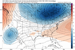
had mentioned way earlier the gfs struggles with handling these waves. Who knowsYou can see how the Baja low is further from California tooGetting lower heights out in the Ne is giving us a better cold press out ahead
Did the UAS get put into tonight's runs?
I’ve got a feeling the 85 north crew are about to get bombed in a good way
 Yep. Just a small tweak in the NE pushed the snow line down 30 miles
It appeared from the post from earlier that at least some data would be in the 0z GFS.Does the 0z GFS have some of the flight data in it?
Sent from my iPhone using Tapatalk


Can you verify that!?!?Wait, I just realized the 0z gfs has newly ingested data from the baha wave!
Just saw a local met on FB say he thinks the GFS does because it actually picked up the previous snow well before the euro.Would it be fair to assume the GFS should have a better grasp on this system since it’s on the west coast of the US instead of the east coast? Also since the GFS is getting more data wouldn’t it be more accurate the next few cycles?


Although that little kicker out of the NW is growing more prominentOK, little fella. Just hang out here in sunny California a little while longer.
View attachment 186689
Looks about the same as 18z??