
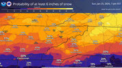
It's still very early to be parsing details like this but this is the warmest sounding from GFS. Warm nose is only about 2C and is shallow. After this, upstairs temperatures crash as the coastal takes over and flips us back to all snow for about 10 hours or so after a 20 hour window at the front end for snow. Crazy stuff.
For reference, down here, our typical snow events really only have a 10 hour window or less with full saturation and temps cod enough for snow.


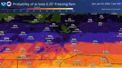


") But this is good news, Larry. Thanks for that. But, but...I want the 5 inches of sleet the clownies were showing before! The seal it with a quarter inch of zr, and top it with 3 inches of snow, and I'm good. 8 inches of paradise. Hope you get some snow out of this!
But this is good news, Larry. Thanks for that. But, but...I want the 5 inches of sleet the clownies were showing before! The seal it with a quarter inch of zr, and top it with 3 inches of snow, and I'm good. 8 inches of paradise. Hope you get some snow out of this!


