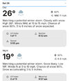
Could be. But that isn't how they usually put it in the grids, if I recall correctly. In any case, they generally err on the less extreme side of things out that far, so perhaps.I presume that would be the temperature at midnight Saturday night going into Sunday, so there would be overlap if they do their nightly lows after daytime highs just like TWC.
-
Hello, please take a minute to check out our awesome content, contributed by the wonderful members of our community. We hope you'll add your own thoughts and opinions by making a free account!
You are using an out of date browser. It may not display this or other websites correctly.
You should upgrade or use an alternative browser.
You should upgrade or use an alternative browser.
Wintry January 23rd-27th 2026
- Thread starter SD
- Start date
SnowNiner
Member
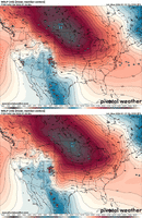
Don’t mean to get repetitive here, but you can amp up all you want, if you continue to strengthen that SE Canada vortex, you can arguably snow/sleet more even with a amped up solution. Notice how it’s slowing. The Arctic high pressure also in result is trending stronger View attachment 185732View attachment 185733
Great point, yeah that visual is good to see how the vortex slowing and strengthening lowers the heights in the east, flattening them and thus making the boundary levels colder.
Would just love to see the AI models doing this though. They still want to amp the SE ridge more giving CLT more ice.
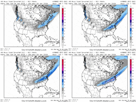
Last 2 Weathernext runs. Small changes here. A bit more cold air damming this run. I'd certainly like to see the AI's trend more south, more west to east slider look. Long way to go
View attachment 185746
Step in the right direction? But yeah all the AI's seem to have that NE/SW orientation that favors the MA/VA for snow. Wish it was reversed.
I could be wrong, but I think the more specific call out to temps falling from high earlier in day happens in the near term wording. Otherwise, this many days out, it is just simple high and low for the day.Could be. But that isn't how they usually put it in the grids, if I recall correctly. In any case, they generally err on the less extreme side of things out that far, so perhaps.
howboutthemdawgs
Member
Stormlover
Member
Where are you in Tenn?I fully understand this is extremely unlikely but this is what the wayyy too early forecast is calling for me in middle tenn
View attachment 185791
considering ALL the caveats but JEEZ US: 18z NAM has a 1056 HP at the end of its run
howboutthemdawgs
Member
FranklinWhere are you in Tenn?
NBAcentel
Member
Looks like it’s doing it to, not as extremely, but it’s doing itGreat point, yeah that visual is good to see how the vortex slowing and strengthening lowers the heights in the east, flattening them and thus making the boundary levels colder.
Would just love to see the AI models doing this though. They still want to amp the SE ridge more giving CLT more ice.
Step in the right direction? But yeah all the AI's seem to have that NE/SW orientation that favors the MA/VA for snow. Wish it was reversed.
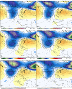
NWG_WX14
Member
love seeing that 1056 high on the NAM. If that high is that strong I think we see another jog south on the 18z guidance
SnowNiner
Member
Looks like it’s doing it to, not as extremely, but it’s doing it View attachment 185796
That last jump was a pretty big one! Let’s see if we can get just east of Maine.
LukeBarrette
im north of 90% of people on here so yeah
Meteorology Student
Member
2024 Supporter
2017-2023 Supporter
Alright time to lock in
Icon first
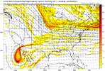
Baja low a little further east than previous runs at 69 hours out.
Icon first
Baja low a little further east than previous runs at 69 hours out.
NWG_WX14
Member
ICON is not as strong and way further south through 114
Do the EC AI ENS MEAN snow maps (WeatherBell and SV) also include sleet and freezing rain? If you look at the data on the EC AI ENS separately for each time interval, for example in TN, although the surface temps are mostly below freezing the 0 line at 850 does not drop south to the southern border of the state until near the end of the event so that would imply that most of the precip in TN would be ice/sleet and not snow as shown on the map above. The EC AI ensemble mean snow maps just don't seem to ever match the EC AI operational run maps.
EC AI ENS MEAN is pure insanity this is out to HR174.
Tsappfrog20
Member
ICON is not as strong and way further southern through 114
Very true but that cold air is getting locked into SC and NC looked like it would be a big run there is I’m seeing right
Sent from my iPhone using Tapatalk
Iceagewhereartthou
Member
Sensible post. One aspect giving me pause echos your point on the high pressure strength. Models do often over estimate those. So far it's been pretty consistent but given the strength of what's modeled we should have more suppressed looks. If that main high weakens at all we lose the cold push that is already a mixed bag for many. I really don't like all the ice talk. We really need the high and cold to verify for once and keep on the press.Too early to make hard and fast predictions for ANYONE as the players are not all on the field yet. That said, I have a hunch this will not go much more South and may actually come North/West some until go time. How much will be critical for p-types in all areas except the mountains, and the two things to keep your eagle eyes on are 1. What does the Baja low do, come east with the system or lag behind to the west. 2. How strong will the parent High pressure be and where does it settle at at onset of precip. The High strength is over modeled by quite a bit IMO and will end up between 1035-38 (as this happens quite frequently from my experience).
To guess what different areas can expect, I think SC will have a good burst of snow in the upstate before a change over to sleet and then ZR. Rest of SC will be either some early sleet and the ZR and then plain cold rain. Ga (except for EXTREME northern sections), will be a little onset ZR then rain. NC will likely see some snow in Charlotte Metro but a changeover to sleet and end as ZR and Raleigh Metro will see more front end snow followed by mostly sleet but a little zr also. Triad Metro will be close, mostly snow or possibly sleet and ending as some zr, while he foothills and mtns go almost all snow, I don't think the coastal plain and coast will see much snow, maybe a little sleet and zr. Virginia will have over a foot of snow in most areas although the extreme southern NC bordering counties could see a little sleet too. Tenn will see a lot of snow and some sleet while N Ala and N. Miss could see sleet quickly followed by a change to zr.
As mentioned, if the High comes in higher than what I predict and sets up in NY, everything I just wrote changes, and if the Baja low gets involved, the northern most states will see a lot of sleet and ZR as this will lead to a much more Northern and Western solution. Amounts are just unpredictable at this stage as we have to see where the exact track is and the strength of the CAD. One thing ecoming pretty obvious is the there is a storm coming and it will be into some very cold before and after air. Aslo I would cut the model totals by 1/3 and the temps as a few degrees to cold.
NWG_WX14
Member
For sure. GREAT look. Wish we could see where it goesVery true but that cold air is getting locked into SC and NC looked like it would be a big run there is I’m seeing right
Sent from my iPhone using Tapatalk
Mahomeless
Member
Almost exactly a year ago, we saw a Deep South snowstorm turn into a GOM coastal blizzard because the models couldn't handle the strength of the cold air coming down properly. This is looking eerily similar in regard to setup....except I see this going from a lower OH Valley/upper Mid South threat, to more of a classic southern slider/Miller A scenario. I fully expect trends to start showing this as early as tomorrow on the AI models and then not a whole lot of wavering except from physics models playing catch up.
LukeBarrette
im north of 90% of people on here so yeah
Meteorology Student
Member
2024 Supporter
2017-2023 Supporter
ICON has not captured the baja low in a few runs. Similar to GFS
iwantsouthernsnow123
Member
It is interesting and something to take note, given the euro western shift on the baja low. Could fold, could not. Only time will telll.ICON has not captured the baja low in a few runs. Similar to GFS
LukeBarrette
im north of 90% of people on here so yeah
Meteorology Student
Member
2024 Supporter
2017-2023 Supporter
Yes 100% the Euro could completely flip a switch and not capture the baja low. The differences are razor thin in my opinion.It is interesting and something to take note, given the euro western shift on the baja low. Could fold, could not. Only time will telll.
wow
Member
We are still shifting south folks.
Not the mama
Member
could someone explain the scenarios of the baja low and what they would mean?
Webberweather53
Meteorologist
We are still shifting south folks.
Yeah I never really understood all the north trend hype on social media.
Top tier shallow and intense Arctic air masses like to bully everything around it and usually speed up compared to model forecasts, especially over the Southern Plains and MS Valley.
This also causes your baroclinic zone and storm itself to shift south. These big SE Canada vortexes also don’t play nice with everything else and like to suppress the storm track.
I personally would favor some continued south trends over a north trend if anything the next day or two, at least until the synoptics are settled in. Then we can worry about those short range things like warm advection and isentropic upglide etc
That ICON run would've been wildThat Granddaddy long fetch lookView attachment 185805
It is simply wishcasting by midwest and new england weenies.Yeah I never really understood all the north trend hype on social media.
Top tier shallow and intense Arctic air masses like to bully everything around it and usually speed up compared to model forecasts, especially over the Southern Plains and MS Valley.
This also causes your baroclinic zone and storm itself to shift south. These big SE Canada vortexes also don’t play nice with everything else and like to suppress the storm track.
I personally would favor some continued south trends over a north trend if anything the next day or two, at least until the synoptics are settled in. Then we can worry about those short range things like warm advection and isentropic upglide etc
And that’s a bunch of ice back towards bama, MS, LA Ark and east TXWas starting to snow in SC.
View attachment 185806
The Baja low kicking east brings more moisture / precipitation with it. Whenever it comes out, or even just a portion of it shears out to the east, it needs to be timed with when the cold air has had a chance to work in. If it were to come out and too quickly, the storm may climb north and be warmer than desiredcould someone explain the scenarios of the baja low and what they would mean?
rburrel2
Member
Everybody should be loving that icon run. Best part is the best stuff happens early on in the run with the PV pressing down more
SnowNiner
Member
That Granddaddy long fetch lookView attachment 185805
Nice and flat look the on the heights, definitely not amped. I would guess clt would be all snow on that one fwiw.
Looks really suppressed though.
WolfpackHomer91
Member
Probably belongs in banter, but the 84hr NAM has the HP about 8-10mb stronger than other models coming down from Canada.
View attachment 185807
So squash city to I-20 with the best returns the probably smh
Sent from my iPhone using Tapatalk
LukeBarrette
im north of 90% of people on here so yeah
Meteorology Student
Member
2024 Supporter
2017-2023 Supporter
iGRXY
Member
GFS will likely be a bit more amped. The ban low is a touch easy which raised heights down stream some

