I still think Raleigh is going to get at least 0.25" of ZR. I know it could be worse but if we get snow, sleet, then that. It's still going to be a major issuewill see...I have hopes to avoid that. Still a nasty sleet/frzn event in Raleigh. Could have been much worse. GSO to CLT looks rough.
-
Hello, please take a minute to check out our awesome content, contributed by the wonderful members of our community. We hope you'll add your own thoughts and opinions by making a free account!
You are using an out of date browser. It may not display this or other websites correctly.
You should upgrade or use an alternative browser.
You should upgrade or use an alternative browser.
Wintry January 23rd-27th 2026
- Thread starter SD
- Start date
Webberweather53
Meteorologist
will see...I have hopes to avoid that. Still a nasty sleet/frzn event in Raleigh. Could have been much worse. GSO to CLT looks rough.
It’s not going to be totally dry even if the bulk of the precip is to the north and west. We will have to contend with many hours of patchy ZR that will be very effective at sticking to everything. Just not a high ceiling of course
Ice storm warning for the entire GSP CWA. Most of the region has 18-24 hours of ZR soundings on the latest NAM
Yup been trying to hammer this for a while now on here and on socials this morning. You are probably going to see the highest ZRs of the event thereThe area is definitely be most concerned about in NC seeing those big time ZR totals is the blue ridge escarpment along the NC-SC border.
Here, you have orographic help to wring out more precip and your higher elevation also means you have less cold nose protecting you from the warm nose aloft, so more likely to flip sooner to ZR here as well
The NAM is 5-10 degrees warmer than FV3 at hr 60. This is hugely consequential because that’s shortly before the “squall line” where the NAM changes most folks over to rain. GSO is instead at 19 degrees as that’s fixing to come through, RDU 24, CLT 23.

Snowflowxxl
Member
FV3 scored big in January of 2025 here. Not even close to the same type of event though so probably a nothing burger
beanskip
Member
Yet another map and post by you that selectively chooses a time frame that makes it seem like "slower" equals "less." Here is the actual comparison of the full storm QPF from 12z to 6z NAM. It's wetter for almost everyone, not drier. Why you are allowed to keep doing this is beyond me.

I don't think Raleigh is going to be lucky enough to make it above 32. Maybe we can pull off a 33 but I've been talking with colleagues and the concern is high with this.It’s not going to be totally dry even if the bulk of the precip is to the north and west. We will have to contend with many hours of patchy ZR that will be very effective at sticking to everything. Just not a high ceiling of course
This was already mentioned. This is agreed...we are talking about the delay of the system. It is slower to arrive.Yet another map and post by you that selectively chooses a time frame that makes it seem like "slower" equals "less." Here is the actual comparison of the full storm QPF from 12z to 6z NAM. It's wetter for almost everyone, not drier. Why you are allowed to keep doing this is beyond me.
View attachment 187973
Webberweather53
Meteorologist
Yup been trying to hammer this for a while now on here and on socials this morning. You are probably going to see the highest ZRs of the event there
We’re getting less QPF but more of that QPF is going to be freezing rain instead of sleet and will have higher ice-liquid-ratios because it’s lighter, at least until the cold front shows up late Sunday.
There’s definitely a trade off here
Wait, the event has already occurred? Not sure you can say "could have been much worse" yet. You, me, and everyone else have no idea what's actually happened until AFTER the event. Yes, it could be a bit less OR more. The models have been showing this for days.will see...I have hopes to avoid that. Still a nasty sleet/frzn event in Raleigh. Could have been much worse. GSO to CLT looks rough.
20 inches of snow. This would be a lifetime event for me in southern Illinois. 
Hmmm. RAH upgraded to Warnings for Triad counties up to Roxboro. Watches left for now remainder of CWA.
Just thinking out loud, they might be considering Ice Storm Warnings instead for the next line or 2 of counties S and E, then Advisories S and E further where .25 accrual or lower is forecasted. Really just a guess though. Wasn’t expecting just part of the CWA to get the upgrade.
Just thinking out loud, they might be considering Ice Storm Warnings instead for the next line or 2 of counties S and E, then Advisories S and E further where .25 accrual or lower is forecasted. Really just a guess though. Wasn’t expecting just part of the CWA to get the upgrade.
rburrel2
Member
Biggest "upside" concern for the upstate is if we don't sleet.... you're going to have to the max super cooled water droplets(thanks to the -8 to -10C cold layer) landing on a 22-24 degree surface. That's as good as it gets for ice accural, even if the rates pick up, you aren't gonna lose a ton to run off.I am getting pretty damn worried for some of these higher end totals in Upstate/NC FH. Reading up on accrual rates and how all that works
I don't think acrual rates will be very good for that final band since we will have probably warmed to 28-30 and lost our cold air feed by that point, so latent heat release be a factor.
If we can escape the first initial batch of heavier precip with mostly sleet instead of freezing rain... then i'd guess we wind up with 1/4 inch of ice which isn't catastrophic.
If that first heavy batch is mostly freezing rain, we're getting 1/2 inch minimium ice accruals.
beanskip
Member
Lot of focus on precip, but also noting the 12z models are gradually stepping down temps in the I-85 CAD regions. It's just a degree or 2 a run -- or 25-50 miles of sub 32F penetration -- but that really starts to add up with multiple runs.
ICON is the latest 12z run to do this.

ICON is the latest 12z run to do this.
SWVAwxfan
Member
winter storm warning for the NRV.
Relax...I'm just talking about the NAM run...what are you talking about...that's just one model but is following theme of less precip in central eastern NC that the AI models are showing.Wait, the event has already occurred? Not sure you can say "could have been much worse" yet. You, me, and everyone else have no idea what's actually happened until AFTER the event. Yes, it could be a bit less OR more. The models have been showing this for days.
Slower does equal less in Georgia.Yet another map and post by you that selectively chooses a time frame that makes it seem like "slower" equals "less." Here is the actual comparison of the full storm QPF from 12z to 6z NAM. It's wetter for almost everyone, not drier. Why you are allowed to keep doing this is beyond me.
View attachment 187973
the snow footprint funny to me on this storm. it's significant not because a strip of 10 counties is getting two feet but because the geographic equivalent of 11 states is all getting one foot. don't think i've ever seen that. great work if you can get it. shame it's not for us but should be excellent snowpack and will shut up a lot of whiners20 inches of snow. This would be a lifetime event for me in southern Illinois. View attachment 187976
Yeah, it's another degrees or two colder than the 06z run. It also seems to be bucking the trend and bringing in the precip slightly quicker.Lot of focus on precip, but also noting the 12z models are gradually stepping down temps in the I-85 CAD regions. It's just a degree or 2 a run -- or 25-50 miles of sub 32F penetration -- but that really starts to add up with multiple runs.
ICON is the latest 12z run to do this.
View attachment 187977
The high resolution WRF-based Cams are incredibly cold.


12z ICON - 1" of QPF for RDU, GSO, CLT with temperatures in the mid to upper teens from hr 36-48 alone. 
I think Alan's map is good for a worst case scenario for most of us. While this better than the doomsday forecasts we were seeing yesterday we are not out of the woods yet. Alan noted the trends showing lesser ice accrual and said these numbers could improve when he releases his next forecast map. Speaking of woods, I can worry a little less about some of the 50-100 foot hardwoods in the strip of woods behind my house coming down in my backyard.Allan just put a new update out


Sent from my iPhone using Tapatalk


Tsappfrog20
Member
I think Alan's map is good for a worst case scenario for most of us. While this better than the doomsday forecasts we were seeing yesterday we are not out of the woods yet. Alan noted the trends showing lesser ice accrual and said these numbers could improve when he releases his next forecast map. Speaking of woods, I can worry a little less about some of the 50-100 foot hardwoods in the strip of woods behind my house coming down in my backyard.
He does say that he might chafe things after the afternoon running he needs too
Sent from my iPhone using Tapatalk
foothillscrewzone
Member
RGEM has been pretty consistent. All of this should be frozen in NC/Upstate SC.png")
Mpirone12
Member
12z ICON - 1" of QPF for RDU, GSO, CLT with temperatures in the mid to upper teens from hr 36-48 alone.

Super James could you post by chance
Sent from my iPhone using Tapatalk
I don’t hate this model forecast, I feel like the icon and cmc have done a surprisingly good job with this oneSuper James could you post by chance
Sent from my iPhone using Tapatalk
You should like this @MSnowAtl this would give much of the area sleet. That’s how cold it is!The high resolution WRF-based Cams are incredibly cold.
View attachment 187978View attachment 187979
With temperatures that cold, this would increase sleet totals in most cases. Is that one inch of QPF for the entire storm or for the twelve hour period mentioned? I hope ICON is overdoing the QPF in that case.12z ICON - 1" of QPF for RDU, GSO, CLT with temperatures in the mid to upper teens from hr 36-48 alone.
Mahomeless
Member
- Joined
- Oct 17, 2023
- Messages
- 900
- Reaction score
- 2,158
At first glance, that looks real concerning for east central AL, where the guard has been completely dropped. However it looks like this is just due to the system slowing, allowing more CAD to filter in, soon to be eroded by WAA. Am I seeing this right?The high resolution WRF-based Cams are incredibly cold.
View attachment 187978View attachment 187979
Wow wow wow! Is it reliable though? I have never seen this product. If this happens I am satisfied. @bouncycornYou should like this @MSnowAtl this would give much of the area sleet. That’s how cold it is!
Over the moon for you Nicky B but we don’t need to see this right now, family20 inches of snow. This would be a lifetime event for me in southern Illinois. View attachment 187976
WolfpackHomer91
Member


WBTV “Futurecast” ….. nice little 4-6hr period of snow for I-40 and North. Then looks like mostly sleet Overnight. If we could get this thing 50 -100 miles more to the South I think 40 could stay primarily snow for a good while into the night Saturday. For Ex: Lynchburg on NwS is at 6-12” Up to 1/4” ICE that’s roughly 100 “Rail Miles” from Browns Summit and Northern GSO
Sent from my iPhone using Tapatalk
Last edited:
Mahomeless
Member
- Joined
- Oct 17, 2023
- Messages
- 900
- Reaction score
- 2,158
Snow report on mPING just northeast of Little Rock, AR....
Super James could you post by chance
Sent from my iPhone using Tapatalk
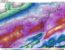
This would be all-frozen for the major NC metros. It's on the wetter side of guidance for sure.

rburrel2
Member
Man, the icon continues to advertise an all-time historical storm for NE GA/Upstate/Central and eastern NC.
I'm not buying the super dry modeling on the southern fringe.
The euro says we have that gulf convection(and thus more precip further south in our area) and at this lead time, it's hard to beat the euro on precip forecasting. and it has support from the rgem/icon/gfs/fv3.
I'm not buying the super dry modeling on the southern fringe.
The euro says we have that gulf convection(and thus more precip further south in our area) and at this lead time, it's hard to beat the euro on precip forecasting. and it has support from the rgem/icon/gfs/fv3.
I don’t buy that.Snow report on mPING just northeast of Little Rock, AR....