Midwest/Midsouth to NE threat. Hopefully we get some more good rain.
-
Hello, please take a minute to check out our awesome content, contributed by the wonderful members of our community. We hope you'll add your own thoughts and opinions by making a free account!
You are using an out of date browser. It may not display this or other websites correctly.
You should upgrade or use an alternative browser.
You should upgrade or use an alternative browser.
Wintry Jan 6-7 2022 Winter potential
- Thread starter SD
- Start date
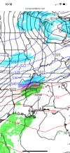
After nice hit to TN and esp NC Mtns. 0z Nam misses by 60 miles. Vort Needs to dig futhure south, just nothing there to make it. Could have a ice event in Cad, but wrong setup in NE. No HP, No confluence.

Heres 0z Nam Clown

Blue_Ridge_Escarpment
Member
RGEM ticked south with its 0Z run. Decent accumulation into the NC Mtns.
JLL1973
Member
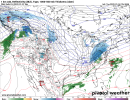
Much more precip for midsouth on 00z gfs
JLL1973
Member
Nice! It should be good up there!Yes and there might be some decent upslope snow on the back side as well. We have a trip to Maggie Valley this weekend to go skiing and snow tubing, and we were really worried last week that the pattern wasn’t gonna shift it time. It looks awesome up there now for the weekend
JLL1973
Member
Canadian says freezing rain
StormStalker
Member
Enough model data to keep it interesting for a couple days.
NWMSGuy
Member
Great stuff @JLL1973! Let’s reel in another system!Canadian says freezing rainView attachment 101748
olhausen
Member
Pretty much every model shows a decent cold snow for northern middle Tennessee. Snow coming in with temps in the mid to upper 20s will be nice if it verifies.
6z GFS throwing out welfare Flakes to central NC


Johnson City up to Bristol to Blacksburg back down to Yance County NC look like the most likely to jackpot a quick 6-8 inch lollipop. Some where in that footprinnt off the overnight ops.
WXinCanton
Member
Looking like you can stick a fork in this one for N GA, N AL, and N MS.
Yep on to the next one!Looking like you can stick a fork in this one for N GA, N AL, and N MS.


LukeBarrette
im north of 90% of people on here so yeah
Meteorology Student
Member
2024 Supporter
2017-2023 Supporter
RGEM says I celebrate again…..hmmm
Turner Team
Member
Bigtime run for our area. Got a bad feeling this one is going to end up trending north though.RGEM says I celebrate again…..hmmm
Stormlover
Member
Not at all. Looking more and more interesting for us.Looking like you can stick a fork in this one for N GA, N AL, and N MS.
Stormlover
Member
From Robert at WxSouth

Blue_Ridge_Escarpment
Member
12Z NAM looking much better. Further south.
NWMSGuy
Member
Not at all. Looking more and more interesting for us.
Wonder which model he is referring to?


- Joined
- Jan 23, 2021
- Messages
- 4,604
- Reaction score
- 15,203
- Location
- Lebanon Township, Durham County NC
RGEM was far enough south that another shift southward and you're gonna be talking about I-40/85 being in the game from Winston to Durham
Stormlover
Member
how about some ice


GSP
"If the low tracks further north from its forecasted position, expect less in the way of frozen precipitation as warmer air is pulled further north. However, more snow for the mountains with the potential of some wintry precipitation slipping east of the mountains Thursday night if the low sinks south from its forecasted position as more cold air is advected into the CFWA."
"If the low tracks further north from its forecasted position, expect less in the way of frozen precipitation as warmer air is pulled further north. However, more snow for the mountains with the potential of some wintry precipitation slipping east of the mountains Thursday night if the low sinks south from its forecasted position as more cold air is advected into the CFWA."
Sneaky south trends would be great
Stormlover
Member
NAM has 0 for huntsville,5 inches for nashville...dig baby!
I think it will move a little more south then pull a slight nw trend late.Almost always a late NW trend. But who knows, I would like to see it slide back west a little more than anything. Don’t like it moving East here in northwest middle tenn.
540 line sinks another 30-40 miles futher SE compared to 6z GFS. one more baby step to go.

That run got BF in the game. Also all north GA counties on TN border hr 57 frame I didnt post.

Watch out Brick/Ollie/Met: Light stuff, but snow is snow

Blue_Ridge_Escarpment
Member
Canadian with improvement on its 12Z run as well.
Stephenb888
Member
I have 2 questions. What exactly causes the NW trend late every time, and has anyone ever seen a storm start tracking south instead of NW when it’s actually go time? Just curious.
accu35
Member

FWIW, and I know this isn’t a Deep South storm but 12z CMC is a few miles south than 0z. Bringing ending snow showers in central Bama.
Good eyes; You getting ready to score again: Think BF has a good shot here to as well as BirdmanCanadian with improvement on its 12Z run as well.

Meanwhile back at the ranch , how close can we get. The coldest of rains

Blue_Ridge_Escarpment
Member
Hopefully another tick or two south for you and others to get in on it.Good eyes; You getting ready to score again: Think BF has a good shot here to as well as Birdman
Meanwhile back at the ranch , how close can we get. The coldest of rains