- Joined
- Jan 5, 2017
- Messages
- 3,806
- Reaction score
- 6,063
37.4/33.6 very light rain but it's not being detected by the Tempest. Wet bulb is 36.3 and has been steady at that measurement for hours.

Sadly... and the current showers passing through are priming us to go right below 32 before that big blob rolls in. All we can hope is that it dies down some, or somehow produces a ---- ton of sleet.Really don't like that area of heavy precip down in southern AL headed straight for the ATL metro...if that stays as potent as it currently looks and it's below freezing here, might as well just lock down the half inch ice totals.
its gonna be ok ANF is saying ATL proper only sees .10"Really don't like that area of heavy precip down in southern AL headed straight for the ATL metro...if that stays as potent as it currently looks and it's below freezing here, might as well just lock down the half inch ice totals.

In west Rowan county. South of Statesville everything has changed over to a very fine light snow.
Yeah was eyeing that as well. We just hit 32 in South Forsyth. If it gets down in the 20’s and that stuff moves in forget about it!Really don't like that area of heavy precip down in southern AL headed straight for the ATL metro...if that stays as potent as it currently looks and it's below freezing here, might as well just lock down the half inch ice totals.
Gsp lowered ice totals a bit in their 10:15 update, feeling pretty good here about escaping the worst with anemic precip totals on the hires models.Not a lick of precip so far in South End Charlotte that I have seen


Yeah was eyeing that as well. We just hit 32 in South Forsyth. If it gets down in the 20’s and that stuff moves in forget about it!
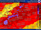
The one on the left.View attachment 188783
So what is the final band that comes through like a squall line? Circle on the left or right?
View attachment 188783
HRRR pretty much nailing it.As of 11pm, GSO is 15 / 9 and RDU is 19 / 12. It is safe to say the models were generally too warm at the surface. Shocker!!
I'm sorry to keep harping about this, but it's like glitter falling. I've never seen it this heavy? I mean, it's literally like shaking up a snow globe. It is beautiful.
Heck, it may be very fine snow, but I think it's frozen drizzle?
Timing is everything. Atlanta won't be at or below freezing until 3 am or so, at the rate of drop. The northern burbs will be there in an hour and a half. I'm now at 37.2/33.7, WB 35.8.I do think it won't be as heavy as it is down there just because the air is drier here and I'm sure the precipitable water values are a lot higher in southern AL, but still...if that hits Atlanta area at the right angle, I can easily see it being the main band of the ice storm and putting down widespread .25-.5+ inch amounts. HRRR would be an immediate bust.
Im convinced the light drops are trying to reform into dendrytes. They are falling again through minus 10 celsius air right after they come through the warm nose. Just a thought. Seeing some sharp pingers jet streak down as well in the flood light. This is as coldest at the surface ive ever seen it precip.

.gif")