-
Hello, please take a minute to check out our awesome content, contributed by the wonderful members of our community. We hope you'll add your own thoughts and opinions by making a free account!
You are using an out of date browser. It may not display this or other websites correctly.
You should upgrade or use an alternative browser.
You should upgrade or use an alternative browser.
Wintry Jan 23-27 Winter Storm Obs
- Thread starter Rain Cold
- Start date
28/10 here, light sleet has stopped for now but looks like more returns building to the west
37/14 and breezy


Finally made it to the freezing mark in Huntsville. Time to enjoy some rain.
It has begun…moderate sleet, NE Chatham County (7.5 miles SSE of Chapel Hill)
HailCore
Member
Do any Mississippi observers have some photos of the sleet out that way? Seeing reports of 1-2 inches of sleet in NW MS which is just bonkers to think about how much precip that would take.
Those models showing 19-20 degrees in Greenville SC , are not going to verify! They were too cold
It’s 36-37 degrees still and even with DPs in the teens, that’ll only wet bulb down to about 26 or so, I’d imagine!
It’s 36-37 degrees still and even with DPs in the teens, that’ll only wet bulb down to about 26 or so, I’d imagine!
If you have RadarScope, it has real-time mesoscale analysis that you can animate.You can use wunderground and throw up the wundermap, turn on weather stations with humidity and dewpoint, just put the map in motion like you would the radar.
Very tiny cute little sleet pellets are falling in Morganton.
LongRanger
Member
They saying on TV MS is already at .75" ice is that true?
Brent
Member
13 degrees waiting for the real event haha
Sctvman
Member
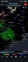
Of course CHS’s radar is out. Have to rely on CAE for local radar
Sctvman
Member
39.2 and dropping steadily now
BufordWX
Member
was looking at the hourly forecast for my area from FFC and they have me dropping to freezing by 9. Gonna look back on this later and see how accurate it is.
I will also add that the temperature here does appear to be starting its descent. It was 43.7 around 2:30 and has droped to 41.9 right now.
I will also add that the temperature here does appear to be starting its descent. It was 43.7 around 2:30 and has droped to 41.9 right now.
Crow
Member
21/-2 in Oxford, NC
I really wish that wundermap would show the trough represented by a dash line that would be moving from NE to SW, but I don't see it. I believe its passing by your area now. You should see your dewpoint descend.was looking at the hourly forecast for my area from FFC and they have me dropping to freezing by 9. Gonna look back on this later and see how accurate it is.
I will also add that the temperature here does appear to be starting its descent. It was 43.7 around 2:30 and has droped to 41.9 right now.
- Joined
- Jan 23, 2021
- Messages
- 4,604
- Reaction score
- 15,203
- Location
- Lebanon Township, Durham County NC
I believe we have a poster from Tupelo or Senatobia who has reported sleet all day.Do any Mississippi observers have some photos of the sleet out that way? Seeing reports of 1-2 inches of sleet in NW MS which is just bonkers to think about how much precip that would take.
Sctvman
Member
Lordhelmit
Member
Sleet in midtown Raleigh
Sctvman
Member
Ice storm warning for Austin, TX
Iceagewhereartthou
Member
Well just had a little shower of RAIN at 38 degrees. No sleet or snow just rain. I was hoping for at least sleet tonight but the column isn't there yet in my area. That can't be a good sign for later.
- Joined
- Jan 23, 2021
- Messages
- 4,604
- Reaction score
- 15,203
- Location
- Lebanon Township, Durham County NC
This is truly, truly incredible:
21/-5 and getting ready to fire off.
21/-5 and getting ready to fire off.
- Joined
- Jan 5, 2017
- Messages
- 3,807
- Reaction score
- 6,063
Are you near Easley or Pickens? You're definitely getting an bid ice storm there. No avoiding it.Over in Pickens county we 40 right now
Seeing a flurry or two
Thank you that supports My (OUR) Weather Obs!Radar
Last edited:
40/22 and slowly falling with NE winds. Wedge is starting to exert its influence here.
rburrel2
Member
Boundary layer too warm at the moment I guess. I don’t think that means anything for tonight.Well just had a little shower of RAIN at 38 degrees. No sleet or snow just rain. I was hoping for at least sleet tonight but the column isn't there yet in my area. That can't be a good sign for later.
- Joined
- Jan 23, 2021
- Messages
- 4,604
- Reaction score
- 15,203
- Location
- Lebanon Township, Durham County NC
I am not entirely sure how the HRRR can be this far off with dewpoints.

LongRanger
Member
PickensAre you near Easley or Pickens? You're definitely getting an bid ice storm there. No avoiding it.
- Joined
- Jan 23, 2021
- Messages
- 4,604
- Reaction score
- 15,203
- Location
- Lebanon Township, Durham County NC
could be you just dont have saturation up to as well.Boundary layer too warm at the moment I guess. I don’t think that means anything for tonight.
- Joined
- Jan 23, 2021
- Messages
- 4,604
- Reaction score
- 15,203
- Location
- Lebanon Township, Durham County NC
18z 12k NAM was off valid for this hour by anywhere from 3 to 6(!!!!) degrees too warm
.png")
Tsappfrog20
Member
Sleet and snow flurries in North Raleigh
Sent from my iPhone using Tapatalk
Sent from my iPhone using Tapatalk