-
Hello, please take a minute to check out our awesome content, contributed by the wonderful members of our community. We hope you'll add your own thoughts and opinions by making a free account!
You are using an out of date browser. It may not display this or other websites correctly.
You should upgrade or use an alternative browser.
You should upgrade or use an alternative browser.
Jan. 17-18, 2026 SE Winter Weather Threat
- Thread starter RBR71
- Start date

Icestorm336
Member
Light snow currently 15 miles northeast of Greensboro. Melting on contact.
norcarolinian
Member
Got our dusting here in NW Guilford…


Wow! That was quick!
blueheronNC
Member
This is been perhaps the best forecasting and nowcasting work I’ve ever seen from the jump and I’ve been on these wx forums since the early 2000s. And that includes all sources and agencies of weather info. Absolutely baller work Eric using fundamentals instead of model regurgitation. And now I’m reminded how useful ACARS data is!1613z RDU sounding shows the wet bulb zero height has crept down to ~900mb/~1900 feet above ground, which is close to the HRRR 2 hour forecast for 18z.
Need the melting snow aloft to drill down thru another 400 feet or so of the near surface warm layer to get some rain/snow mix over the Triangle area.
That also lines up with the elevation differences between Raleigh (315 feet) & Randleman (715 feet), where it's starting to changeover to snow or a mix.
View attachment 185130
View attachment 185131
- Joined
- Jan 23, 2021
- Messages
- 4,604
- Reaction score
- 15,203
- Location
- Lebanon Township, Durham County NC
This is been perhaps the best forecasting and nowcasting work I’ve ever seen from the jump and I’ve been on these wx forums since the early 2000s. And that includes all sources and agencies of weather info. Absolutely baller work Eric using fundamentals instead of model regurgitation. And now I’m reminded how useful ACARS data is!
Agreed but I’ve come to expect it from Eric.
Dunkman
Member
Nice! Hasn’t even come close to sticking here near the Palladium in High Point.
Moderate snow now. Took a while to get all the mixing out. Should bode well for you guys over toward triangle northern coastal plain
Btownheel
Member
Snowing solidly in Gibsonville.
Sent from my iPhone using Tapatalk
Sent from my iPhone using Tapatalk
NWG_WX14
Member
not in oak ridge today but family is saying that it’s a solid dusting and still coming down well.
39 .85 in the bucket. Slightly mad it didn't snow but the rain was so necessary
Oh come on you can do it
tazaroo
Member
Finally changed to snow in Asheboro about 15 minutes ago. Precipitation ending soon. 35 degrees.
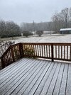
Temps actually did moderate earlier as precip ramped up but it's back down to 39 now and looking at your maps, it is so close to being able to mix a few flakes in. I might still have time to see a few.Oh come on you can do itView attachment 185168
Finally made the transition here. Thought it would never come
Yea its coming down pretty good right now. Hardest snow we have had all season. Like 4th or 5th time now and can hardly net a trace each one. But next weekend we are gonna make up for it Biggly.Finally changed to snow in Asheboro about 15 minutes ago. Precipitation ending soon. 35 degrees.

Last edited:
39 .85 in the bucket. Slightly mad it didn't snow but the rain was so necessary
Well, we overperformed on liquid equivalent, at least. We needed it! Hopefully, with the skies now healed, we can overperformed on future events that actually have significant wintry components.
It's pouring rain right now, and as far as I can tell it's still all-rain here in NE Chapel Hill. If Hillsborough has changed over, perhaps it won't be too much longer, though. We are about 300 ft. lower in elevation, though, if I remember right...
1.58" of liquid here today.
Icestorm336
Member

- Joined
- Jan 23, 2021
- Messages
- 4,604
- Reaction score
- 15,203
- Location
- Lebanon Township, Durham County NC
Roxboro showing snow at 1.25 vis. Also showing on my front yard camera at home.
If we over towards the Triangle can changeover to snow we will stand a little better shot at it sticking than earlier with the better diurnal timing, just a couple hours before sunset. Silver linings, LOL. But if we don’t changeover, it doesn’t matter!!!
Heelyes
Member
Snow west of pittsboro
Looks like boundary temps are still an issue even as far north as Foxboro. I was really hoping for a good snow bowl
packfan98
Moderator
Looks like the snow is winding down here. A good solid hour of flakes falling. I'm still calling it a win.
- Joined
- Jan 23, 2021
- Messages
- 4,604
- Reaction score
- 15,203
- Location
- Lebanon Township, Durham County NC
Grass is already trying to turn white at the house. I was not expecting that.
- Joined
- Jan 23, 2021
- Messages
- 4,604
- Reaction score
- 15,203
- Location
- Lebanon Township, Durham County NC

Yeah it’s puking huge flakes here all of a sudden in NE DurhamGrass is already trying to turn white at the house. I was not expecting that.
Snow is mixing in! At last!
Tsappfrog20
Member
Hoping it’ll start here in Youngsville soon
Sent from my iPhone using Tapatalk
Sent from my iPhone using Tapatalk
Brandon10
Member
Guess we can turn attention to a MUCH more favorable situation next weekend and beyond.
rusrius
Member
Snow drought continues. Got half an inch of only rain here as temps never dropped under 40. On to the next.
SouthSideYankee
Member
Light snow mixing in here- south Durham