Webberweather53
Meteorologist
What about for North Georgia, are you liking the looks of this area?
If you can get precip when the main wave comes overhead in the morning that would work.
What about for North Georgia, are you liking the looks of this area?
Looks like BL temp problems here for whatever light stuff we get per HRRR. Wild how Central/SE GA looks to get blasted but NE NC and SE VA all rain. We'll see how that pans out and if NW trends continue.lol it’s in the mountains of NC at 10 pm tonight

The surface warm layer is very shallow..it won't take long to over come it. Per nam and gfs At 06z wetbulb zero heights are at 950mb and by 09z its just a couple hundred feet off the surface. I've seen worse.Athens GA is gonna be riding a fine line unless Teal 72 bumps the cold down and precip up a bit.
Whatever falls will likely melt relatively quick unless someone happens to get pasted
I’ll be in Blacksburg tonight so probably won’t have issues with temps there. Can’t believe how much this has backed up. Had graupel in Roanoke too this morning. I start classes back on Tuesday and I work tomorrow and Monday…Looks like BL temp problems here for whatever light stuff we get per HRRR. Wild how Central/SE GA looks to get blasted but NE NC and SE VA all rain. We'll see how that pans out and if NW trends continue.
Also had a dusting of graupel this am.
Brother. No hate here. But you are digging yourself a hole here if a swath of heavy snow pumps out 1-2 inches of snow outside the mountains across the Southeast. I know you are confident. and you might be right.. But there is no way in heck I would speak in such absolutes like you are.The 12z HRRR is basically all rain outside the mountains and foothills. Makes sense to me
Brother. No hate here. But you are digging yourself a hole here if a swath of heavy snow pumps out 1-2 inches of snow outside the mountains across the Southeast. I know you are confident. and you might be right.. But there is no way in heck I would speak in such absolutes like you are.
Same thoughts apply man. But we will see!My brother in Christ im talking about NC
Perfectly stated for N. Georgia east of 85.I like what I am seeing on the 12Z RAP for places further north as there has been another small tick northward with the early finger band of precip which produces heavier returns and overlaps the cold air earlier similar to the 12Z HRRR allowing dynamic cooling to take over the change precip over to wet snow. This would even put some folks north of I-85 in the game for falling flakes, even the mountains as there appears that moisture will be moving that far northward. However, unless this narrow band of heavier moisture significantly expands and overperforms during the event this evening, I don't see this being able to accumulate too well other than a mix or some nice flakes for a bit. The main question for GA folks along I-85 in terms of accumulations is can we get the second wave of precip during the morning to overperform and expand on the northern side when we have favorable temperatures in place.
View attachment 184556


it shifted back SEPrecip bomb on the nam
View attachment 184559


SE shift...wow still at this stage!Either the NAM takes a horrific L here or it’s on to something. Hope it’s right. View attachment 184563View attachment 184562

Either the NAM takes a horrific L here or it’s on to something. Hope it’s right. View attachment 184563View attachment 184562
Not unless you have been living under a rock for the last 20 years.12 NAM drives a stake into N. Ga weenies.
View attachment 184564
Not so fast12 NAM drives a stake into N. Ga weenies.
View attachment 184564

 We roll with this FV3 bad boy.

Jimmy to Mitch sweet spot!Either the NAM takes a horrific L here or it’s on to something. Hope it’s right. View attachment 184563View attachment 184562
Not so fastView attachment 184568
LOL. I was perusing this run as you posted. That's one heck of an NW jump on the FV3! I want whatever it's smoking.Not so fastView attachment 184568

Watch out with this model, there are significant dry air issues going on. Half of that precip on the northern edge would never reach the ground with the soundings shown, but at the same time even central and southern GA would struggle with dry air after getting 2-3 inches of snow on the accumulation map, so maybe take the dry air factor with a grain of salt. I think if this depiction came true, there would be enough time to saturate the atmosphere, heck that would suggest a few hours of snow right over ATL which should provide a buffer allowing dry air to saturate and some time for actual snow.The NAM is trash to me now.
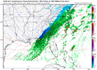
View attachment 184566View attachment 184569

I’m with Webber here….its going to be hard to find a snowflake anywhere on this board except in extreme western NC
 This is why I am still a little more optimistic to see some snow here tomorrow. The NAM is again showing increased forcing with the low pressure pulling more to the coast, increasing frontogenesis enough to give a band of wet snow. I’m not saying it will happen but also why I don’t think it is good to speak absolutes about the weather
You can’t see a flip to snow as the surface low pulls away? I don’t think that’s out of the question. 1-2 hours of wet snow for central NCThe 12z HRRR is basically all rain outside the mountains and foothills. Makes sense to me
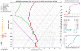
Yikes, you're not kidding. This is my sounding during the best reflectivity returns. What's crazy is the accumulation maps, WTH?Watch out with this model, there are significant dry air issues going on. Half of that precip on the northern edge would never reach the ground with the soundings shown, but at the same time even central and southern GA would struggle with dry air after getting 2-3 inches of snow on the accumulation map, so maybe take the dry air factor with a grain of salt. I think if this depiction came true, there would be enough time to saturate the atmosphere, heck that would suggest a few hours of snow right over ATL which should provide a buffer allowing dry air to saturate and some time for actual snow.
![soundings-[33.83,-83.83]-hrwfv3-ref1km_ptype-us_se-2026011712-25.png](https://southernwx.nyc3.digitaloceanspaces.com/data/attachments/184/184589-f8bf640bb30c717ef69faf0455487552.jpg "soundings-[33.83,-83.83]-hrwfv3-ref1km_ptype-us_se-2026011712-25.png")
That's not what he's been saying. He's been talking about NC and sc having issuesI’m with Webber here….its going to be hard to find a snowflake anywhere on this board except outside of extreme western NC
Sounds good to me..has me between 0.30 to 0.40...lol. Interesting that both models have greatly increased totals over central ga and sc though.The NAM is trash to me now.
View attachment 184566View attachment 184569

Yep. If other models were showing snow and NAM rain it would be game over. Still don’t really trust it here though.If the NAM is saying you’re all good on temps, that’s normally all you need. Of course that can change in an instant but for now it appears there will be some snow with this system