Radar shows snow trying to catch up but probably too little too late.2840 is going to try and catch up, but need rates later this morning; time will tell
-
Hello, please take a minute to check out our awesome content, contributed by the wonderful members of our community. We hope you'll add your own thoughts and opinions by making a free account!
You are using an out of date browser. It may not display this or other websites correctly.
You should upgrade or use an alternative browser.
You should upgrade or use an alternative browser.
Jan. 17-18, 2026 SE Winter Weather Threat
- Thread starter RBR71
- Start date
Drizzle Snizzle
Member
I measured just under 1”
EastmanGAWX
Member
2.5 inches reported in Cuthbert, GA
Webberweather53
Meteorologist
12z NAM is a lot warmer in NC. Lol
yeah looking over the data; us in the carolinas, pray for a miracle
still pos tilted it seems too
still pos tilted it seems too
Relocated a bit south to Perry to hit this last band! Let’s rage 
LongRanger
Member
blueheronNC
Member
At best a dusting from Eden to Yanceyville to Roxboro. Ouch.12z NAM is a lot warmer in NC. Lol
GeorgiaGirl
Member
Hi from Keysville, GA. Just rain right now but I did see some snow try and mix in while driving.
Can't believe I'm doing this, but I am going to attempt to drop down to Wrens.
Can't believe I'm doing this, but I am going to attempt to drop down to Wrens.
Hi from Keysville, GA. Just rain right now but I did see some snow try and mix in while driving.
Can't believe I'm doing this, but I am going to attempt to drop down to Wrens.
It appears per radar that Augusta might be about to get hit hard with something!
Webberweather53
Meteorologist
Womp
My rule of thumb with these overrunning type events that like to trend north at the last sec is take the warmest model and lean hard in that direction
That seems to have held true again here despite the NAM being cold for once

My rule of thumb with these overrunning type events that like to trend north at the last sec is take the warmest model and lean hard in that direction
That seems to have held true again here despite the NAM being cold for once
Brent
Member
Wow Macon
2” reported at Byron, GA! (Just WNW of Warner Robbins)
0830 AM SNOW 2 N POWERVILLE 32.63N 83.79W
01/18/2026 E2.0 INCH PEACH GA PUBLIC
AN ESTIMATED 2 INCHES OF SNOW FELL AT HAYES
CT IN BYRON.
*Edit: Byron later corrected down from 2” to 0.5”
0830 AM SNOW 2 N POWERVILLE 32.63N 83.79W
01/18/2026 E2.0 INCH PEACH GA PUBLIC
AN ESTIMATED 2 INCHES OF SNOW FELL AT HAYES
CT IN BYRON.
*Edit: Byron later corrected down from 2” to 0.5”
Last edited:
Wow!!!! Heaviest of the day
NCPROGRAMMER
Member
I have learned to never underestimate your ability to nail a forecast. You have done this time and time again here in the Carolinas. Much respect! On to the next one.Womp
My rule of thumb with these overrunning type events that like to trend north at the last sec is take the warmest model and lean hard in that direction
That seems to have held true again here despite the NAM being cold for once
View attachment 184975
Forevertothee
Member
Rain-Snow mix reported on social media in Greenwood, Sc.
EastmanGAWX
Member
I’m still waiting on the changeover, Cochran, GA (17 miles north of me) has a dusting.
Genuinely some of the heaviest snow I’ve ever seen rn. Pancakes
GeorgiaGirl
Member
It appears per radar that Augusta might be about to get hit hard with something!
I Did see an area that tried to be all snow, but with where I'm stopped, it's more rain.
Gonna try and proceed further west,
Ofc, I say so and more snow is mixing in now.
Makeitsnow
Member
Hi from Keysville, GA. Just rain right now but I did see some snow try and mix in while driving.
Can't believe I'm doing this, but I am going to attempt to drop down to Wrens.
Thomson has changed over based on sensor network. So augusta probably will within the half hour.
Brent
Member
Macon again
Biggest winner so far: 3” at Monticello, GA!
0908 AM SNOW MONTICELLO 33.30N 83.68W
01/18/2026 M3.0 INCH JASPER GA BROADCAST MEDIA
REPORT FROM MEDIA OF 3 INCHES OF SNOW IN
MONTICELLO.
*Edit: later corrected down to 2” from 3”.
0908 AM SNOW MONTICELLO 33.30N 83.68W
01/18/2026 M3.0 INCH JASPER GA BROADCAST MEDIA
REPORT FROM MEDIA OF 3 INCHES OF SNOW IN
MONTICELLO.
*Edit: later corrected down to 2” from 3”.
Last edited:
Wow!!!! Heaviest of the day
Nothing beats low vis in snow. Great video.
scncborderwx
Member
 Ate my words. Love to see it!
Makeitsnow
Member
Biggest winner so far: 3” at Monticello, GA!
0908 AM SNOW MONTICELLO 33.30N 83.68W
01/18/2026 M3.0 INCH JASPER GA BROADCAST MEDIA
REPORT FROM MEDIA OF 3 INCHES OF SNOW IN
MONTICELLO.
Wild stuff. That certainly qualifies as a major snow. Tenille, well east of macon is 33/all snow so that area is going to do very well too.
GeorgiaGirl
Member
Ok, this was completely worth it.
In the Wrens city limit. There is heavy snow right now.
I'm just going to try and figure out another way back as that drive wasn't fun.
In the Wrens city limit. There is heavy snow right now.
I'm just going to try and figure out another way back as that drive wasn't fun.
Forevertothee
Member
Snow reports on social media snow southern Greenwood, SC. Snow in Abbeville, SC.
Tarheel17
Member
Up to 42.4 degrees near RDU
Drizzle Snizzle
Member
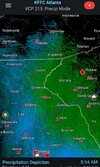
The area around Hawkinsville is getting it pretty goodRadar is quite impressive in a band in GA centered from Albany/Tifton to Dublin to Augusta.
Steady cooling now at my location in Lexington, SC
39.7°
Honestly a little surprised we’ve dipped sub 40
39.7°
Honestly a little surprised we’ve dipped sub 40
Steady cooling now at my location in Lexington, SC
39.7°
Honestly a little surprised we’ve dipped sub 40
its on the other side of saluda, its close 850 about to come over and we just hope for the best band development
You are going to rub this in until the last 40F rain drop aren’t you…Womp
My rule of thumb with these overrunning type events that like to trend north at the last sec is take the warmest model and lean hard in that direction
That seems to have held true again here despite the NAM being cold for once
View attachment 184975

I admire your relentlessness for central NC pain.
 ️
️Drizzle Snizzle
Member
I think 1” will be my final total. I’m happy
Makeitsnow
Member
Steady cooling now at my location in Lexington, SC
39.7°
Honestly a little surprised we’ve dipped sub 40
it was surprising how fast the temp dropped here. It went from 38 to 33 in about 20 minutes. The magic temp seems to be about 36.5 to 37 to see a changeover. It was here.
Steady cooling now at my location in Lexington, SC
39.7°
Honestly a little surprised we’ve dipped sub 40
Radar indicates your area about to start getting a nice hit with whatever.
Sctvman
Member
Looking at GDOT cameras the cutoff is very sharp just west of Madison on I-20. Snowing in Sandersville but not in Dublin. Still wet in Thomson
Perry, GA 