I call this the" House Money Storm" for my area. If we scratch because we end up with no moisture or 33 an Rain. Its all good as bigger ducks are on the pond next couple weeks.
I really hope the deep south, GA crowd can cash in on back side. Ill have some great opportunities after this,but its so hard and rare, to get frozen precip into Georgia Coastal plain, lowlands of SC. Hope they can make Hay while they can.
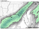
Me,packfan few others in this area are literally on the line to net .3 qpf + or nada. Very sharp cutoff. On top of that we are cold enough for snow on every model run and always get a shade of some sort on the 10:1 ratio clowns. But just like the razor thin line on qpf, its even more pronounced In temp dept.
I have checked soundings on every model run and its always a 32 - 33 snow ptype.
So my expectation are low, very tempered. Thats 2 major red flags.
But if we score any slushy accum on car top, mulch etc, im chalking it up as a win.
This has been fun to track imo. Just seeing how one little micro wiggle, affects everything.
It never pans out exactly as all model consensus says up till actual go time. And even the call maps, from the best, with excellent reasons, case points. Always have a , "I should have known, caught that" case in point getting made when reflecting back doing post annalysis.
One of the most popular is never ignore the Nam soundings, warm nose detection. It hasnt shown that yet interestingly. You would think of all the situations weve expierenced, the Nam would be trashing this storm to death. But its actually been giving it the coldest looks, soundings wise.