SimeonNC
Member
I’m really not sure where you’re seeing that. Even though the models now have the storm coming in a bit further East, the spaghetti plots are still pretty clustered across Central GA and SC. That’s actually a track that would put most of NC in heavy rainfall which is what the models are showing right now. If anything the latest runs have more of NC getting in excess of 4 inches of rain and the latest Euro has CLT getting close to 8. A couple things to remember... 1. It’s very possible that the moist flow ahead of the center is going to spark some heavy rainfall in around the wedge boundary and this could be well ahead of the center. 2. Once Gulf coast tropical systems are inland, they tend to have the heaviest shield of rain to the north and northwest of the center... and this could be enhanced by the approaching front. Now I don’t think Widespread 8 inches of rain is going to happen for Charlotte, because I’m not sold on the slow movement of the Euro, but 4-6 Inches with localized heavier amounts would still seem reasonable.I swear , a couple more shifts SE or S, NC will be dry
I’m really not sure where you’re seeing that. Even though the models now have the storm coming in a bit further East, the spaghetti plots are still pretty clustered across Central GA and SC. That’s actually a track that would put most of NC in heavy rainfall which is what the models are showing right now. If anything the latest runs have more of NC getting in excess of 4 inches of rain and the latest Euro has CLT getting close to 8. A couple things to remember... 1. It’s very possible that the moist flow ahead of the center is going to spark some heavy rainfall in around the wedge boundary and this could be well ahead of the center. 2. Once Gulf coast tropical systems are inland, they tend to have the heaviest shield of rain to the north and northwest of the center... and this could be enhanced by the approaching front. Now I don’t think Widespread 8 inches of rain is going to happen for Charlotte, because I’m not sold on the slow movement of the Euro, but 4-6 Inches with localized heavier amounts would still seem reasonable.
and I would pay very particular to where that wedge boundary is setting setting up on Wednesday into Wednesday night as along it and just to the north of it could see some very heavy rainfall out ahead of the main batch. If you remember two years ago as Michael was making landfall on the Panhandle and there was some dryer air that had wedges into the Piedmont and Foothills... an area of very intense rainfall developed along the boundary from the SSE flow ahead of Michael. Training set up in York and northwest Chesterfield county in SC and eastern Union, Western Anson, and into Stanly Counties in NC. I had nearly 4 inches of rain in 6 hours at my house in Wingate which was actually a little more than I got the next as Michael moved through. Of course Michael raced through this area and it looks as though Sally is gonna take a couple days to pass by.Yeah, not quite sure where these "clouds and mist" forecasts are coming from. Like you aforementioned, weakening tropical systems ALWAYS have the highest precip totals well to the North and west of the center of circulation. Unless this system stays 200 miles south of us, we're going to get rain. Add the wedge boundary and front to the picture and we're pretty much guaranteed some substantial rainfall.


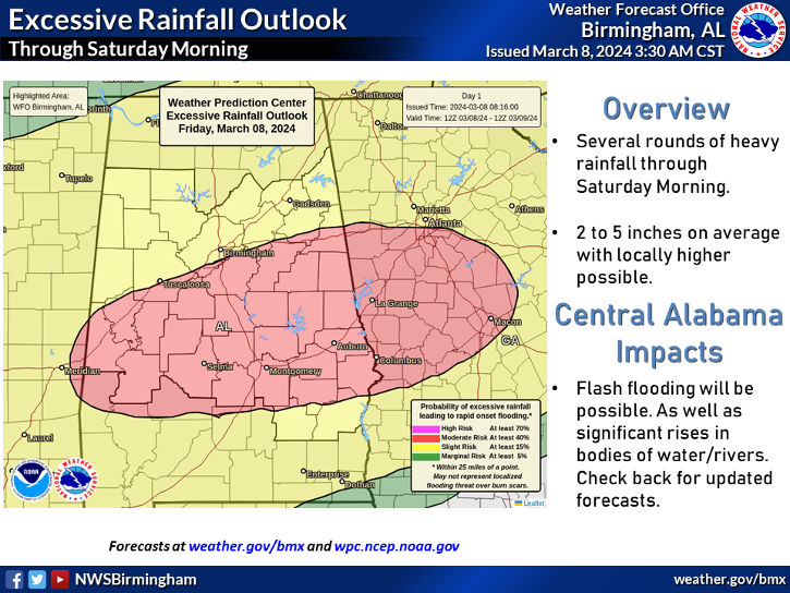
This looks more likely unfortunately.View attachment 48589
18z NAM sure doesn’t jive with these massive rainfall totals I’m seeing out there for those of us well inland. GFS was wetter but it still wasn’t showing the 6-8+ inch totals for my area that many are forecasting.
This looks more likely unfortunately.
The higher resolution 3km NAM has the rainfall farther north. It doesn’t go out as far so we can’t see the full picture, but that heavy rain blob looks feistyView attachment 48589
18z NAM sure doesn’t jive with these massive rainfall totals I’m seeing out there for those of us well inland. GFS was wetter but it still wasn’t showing the 6-8+ inch totals for my area that many are forecasting.


To add to this the entire 20 member 18z GEFS suite has heavy rainfall quite a bit farther north then the NAM. I could be wrong on this but I feel like the NAM has done this before with a tropical system by keeping the rainfall too far south until correcting north at the last minute.The higher resolution 3km NAM has the rainfall farther north. It doesn’t go out as far so we can’t see the full picture, but that heavy rain blob looks feisty View attachment 48590View attachment 48591

One of the things that is probably being leaned on with heavier rainfall forecasts is simple climo. Gulf coast tropical cyclones always have the heaviest rainfall to the north and northwest of the center once inland, especially ones coming in along this part of the coast...just the location and the moist flow coming around the center have an upsloping to them. Now perhaps NW Alabama and Northern Mississippi May not get in on the heaviest rain now that the storm looks to be making landfall further east, but I would still NE Alabama and Northern GA should still see some fairly heavy totalsI’m not buying the insanely high totals well inland and north at all. If models trend towards that then great, but I’ve seen enough of a trend away from that today that I was surprised when they upped totals this evening
I would be shocked if this verifies. I can’t remember the last time we had this much from a tropical system.
To be fair Northern GA somehow always misses the core of tropical systems as they come inland. Usually we only get them if they are really big.I would be shocked if this verifies. I can’t remember the last time we had this much from a tropical system.
I agree, was sorta shocked to see BIrmingham NWS Office go with 6” to 8” totals this afternoon package.I’m not buying the insanely high totals well inland and north at all. If models trend towards that then great, but I’ve seen enough of a trend away from that today that I was surprised when they upped totals this evening
Even with Irma I think we only got like 2-3in. 6-8 would be crazy and case major flooding around Atlanta.To be fair Northern GA somehow always misses the core of tropical systems as they come inland. Usually we only get them if they are really big.
(EX. Irma)
Irma wasn't influenced by a trough pulling up even more moisture into GA so the rain shield wasn't as heavy.Even with Irma I think we only got like 2-3in. 6-8 would be crazy and case major flooding around Atlanta.
I don’t think there’s really much confusion on speed and timing for the Carolinas. GSP covers very well in the afternoon discussion as to why they are going with 2-6 inches of rainfall for their entire forecast area with locally heavier amounts. They mention how Sally is not the only piece of the puzzle that sets the Carolinas up for heavy rainfall. Now I would tend to agree that Northern GA will likely end up with more rainfall than anywhere in the Carolinas with one exception... wherever the wedge boundary sets up on Wednesday could be a focal point of rainfall well out ahead of storm itself... most likely that would be the Eastern Upstate of SC into the the SE Piedmont of NC. Even Brad P. is going with 4-7 inches across the southern NC mountains and foothills and western Upstate with 3-5 inches for the southern Piedmont and 2-4 inches from the I-40 corridor to VA border... anyone that watches him regular knows that those are some bullish amounts for him more than 48 hours out.Looks like some confusion here I’m reading. Go to the NHC says fast moving system for us. It’s only slow near landfall. Quiet a big difference there. This helps us a lot.. lessens some of the flood threat. A CAT5 or tropical depression the point is mute up here when it stalls down there with historic flooding it’s gonna die on land. This could have been much worse for us had the track shifted north and the system was quicker then stalled near Atlanta. There’s no chance of that happening.
I don’t think there’s really much confusion on speed and timing for the Carolinas. GSP covers very well in the afternoon discussion as to why they are going with 2-6 inches of rainfall for their entire forecast area with locally heavier amounts. They mention how Sally is not the only piece of the puzzle that sets the Carolinas up for heavy rainfall. Now I would tend to agree that Northern GA will likely end up with more rainfall than anywhere in the Carolinas with one exception... wherever the wedge boundary sets up on Wednesday could be a focal point of rainfall well out ahead of storm itself... most likely that would be the Eastern Upstate of SC into the the SE Piedmont of NC. Even Brad P. is going with 4-7 inches across the southern NC mountains and foothills and western Upstate with 3-5 inches for the southern Piedmont and 2-4 inches from the I-40 corridor to VA border... anyone that watches him regular knows that those are some bullish amounts for him more than 48 hours out.
If these totals verify, there will be some serious flooding around here.Even with Irma I think we only got like 2-3in. 6-8 would be crazy and case major flooding around Atlanta.
From what I can tell, probably very little sustained. I'd be more worried about a random squall line during them if anything. Probably a low risk of that too.I know this is a rain not wind gig, but are we dealing with any kind of winds here? cause after 8 inches of rain.....?
I’ve not seen anything to make me think winds will be a issue. I’ve seen 10-15 with gusts 25mph last I checked. This could be a flooding event for sure if it happens.I know this is a rain not wind gig, but are we dealing with any kind of winds here? cause after 8 inches of rain.....?
Honestly I took a couple meteorology courses in college as electives simply because I love weather. However I think I’ve learned more about forecasting from reading NWS discussions and reading the posts from Mets on this board the last few years. Sorry if this is banter.It’s crazy how reading discussions really helps you grow as a forecaster.
Sent from my iPhone using Tapatalk

GSP tonight.

Sent from my iPhone using Tapatalk
That’s just through 8pm Thursday more rain would fall Friday
Sent from my iPhone using Tapatalk
GSP has 4-8” widespread across the upstate.That’s just through 8pm Thursday more rain would fall Friday
Sent from my iPhone using Tapatalk
GSP really hoaning in on the upslope along with the frontal boundary.
Typically at this time range they will use a blend of the GFS and Euro, but keep in mind that since the forecast involves a tropical system, they’ll use the forecast track that the NHC is putting out. GSP doesn’t usually mention the NAM outside of 60 hours.Which model are they leaning on?
Sent from my iPhone using Tapatalk
GSP tonight.
Sent from my iPhone using Tapatalk
