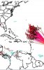
Either way big swells coming to the east coast will be nice for a beach trip. If it were to hit land I believe it’s gonna be Bermuda up into New England/Canada area…not the Carolinas.
-
Hello, please take a minute to check out our awesome content, contributed by the wonderful members of our community. We hope you'll add your own thoughts and opinions by making a free account!
You are using an out of date browser. It may not display this or other websites correctly.
You should upgrade or use an alternative browser.
You should upgrade or use an alternative browser.
Tropical Hurricane Larry
- Thread starter Snowfan
- Start date
Shaggy
Member
There's just no real pathway for Larry to go much further west than already modeled. That first trough will turn him and that 2nd trough dropping down and moving off NE will kick him. The models are going to have to change some pretty large scale features in big ways to change this outcome IMO.
Henry2326
Member
Henry2326
Member

Shaggy
Member
There's just no real pathway for Larry to go much further west than already modeled. That first trough will turn him and that 2nd trough dropping down and moving off NE will kick him. The models are going to have to change some pretty large scale features in big ways to change this outcome IMO.
Troughs coming in slightly weaker and flatter at 102 and the gfs is further west. Still looks to recurve but it's those kinds of changes that have to trend weaker and flatter if this is going any further west.
9 times out of 10 models miss how far west before they actually recurve out to sea. It’s dangerous tho in September these troughs can spawn systems in the gulf or Bahamas with a much greater chance of impacting the s/e vs African waves.
Keep in mind that there has yet to be any south of due west motion since TC genesis. So, that actually occurring during the next 12-18 hours remains to be seen. The modeling I've seen is due west or just N of due west. So, it is possible. In case it does, I have my own list as of 2011 because I did my own research on WSW motion in the E ATL 10+ years ago:
From my 8/31/11 analysis:
"Looking back all the way to 1851, I found only 30 TS+'s that showed some WSW motion during their early lives in the eastern Atlantic (including just during TD stage), indicative of pretty strong E ATL sfc high pressure to the north. Here are some stats:
1) Out of these 30, 12 (40%) hit the US (all but Carol of 1953 hit as a hurricane..Carol was a grazer), which is 2.4 times the 1 in 6 chance for ALL Cape Verde type storms since 1960 (w/# days African coast to US)(all but Able and Fran were cat 4+ at strongest):
- #6 of 1893 (GA/SC) (14)
- #4 of 1928 (FL)(11)
- #4 of 1947 (FL, LA) (14)
- Able of 1952 (SC) (13)
- Carol of 1953 (ME grazed) (11)
- Donna of 1960 (FL, NC, New England) (12)
- Dora of 1964 (FL) (13)
- Allen of 1980 (TX) (12)
- Hugo of 1989 (SC) (12)
- Fran of 1996 (NC) (14)
- Isabel of 2003 (NC) (15)
- Ivan of 2004 (AL/FL) (16)
The 18 that didn't hit the US (cat 4+ at strongest only Gabrielle, Luis, Dean, Bill, and Igor):
- #2 of 1927
- Charlie of 1950
- Dog of 1951
- Fox of 1951
- Carol of 1965
- Anna of 1969
- Christine 1973
- Earl 1980
- Gabrielle 1989
- Fran of 1990
- Danny of 1991
- Luis of 1995
- Gustav of 1996
- Ivan of 1998
- Dean of 2007
- Bill of 2009
- Fred of 2009
- Igor of 2010"
To update my 2011 analysis, I just checked for WSW movers during 2011-20 and found one: Helene of 2018. It didn't hit the US:
https://www.nhc.noaa.gov/data/tracks/tracks-at-2018.png
So, if I add that to my previous analysis, I now have 12 hitting the US and 19 not. That is still a pretty high 39% US hit rate, much higher than that for all eastern Atlantic storms. Also, if I were to ignore those that occurred during El Nino since we're not in one, the % is even higher.
Larry has still not moved S of due W between any two reference points. It moved due west between 8 AM and 2 PM yesterday and otherwise N of due W to WNW. So, at this point, the S of due W stats are pretty much irrelevant.
12Z UKMET: 922 mb!
HURRICANE LARRY ANALYSED POSITION : 13.3N 33.3W
ATCF IDENTIFIER : AL122021
LEAD CENTRAL MAXIMUM WIND
VERIFYING TIME TIME POSITION PRESSURE (MB) SPEED (KNOTS)
-------------- ---- -------- ------------- -------------
1200UTC 02.09.2021 0 13.3N 33.3W 993 48
0000UTC 03.09.2021 12 13.8N 37.2W 988 50
1200UTC 03.09.2021 24 14.4N 40.5W 983 52
0000UTC 04.09.2021 36 15.3N 43.6W 977 62
1200UTC 04.09.2021 48 16.3N 46.2W 975 65
0000UTC 05.09.2021 60 17.6N 48.3W 971 65
1200UTC 05.09.2021 72 19.2N 50.6W 969 68
0000UTC 06.09.2021 84 20.9N 52.5W 960 77
1200UTC 06.09.2021 96 22.2N 54.4W 949 81
0000UTC 07.09.2021 108 23.6N 56.1W 941 97
1200UTC 07.09.2021 120 25.0N 57.8W 930 106
0000UTC 08.09.2021 132 27.3N 59.1W 922 107
1200UTC 08.09.2021 144 29.9N 60.0W 922 111

Henry2326
Member
Henry2326
Member


Henry2326
Member
Henry2326
Member
0Z UKMET is again down to 922-3 mb and passes only 150 miles east of Bermuda then:
HURRICANE LARRY ANALYSED POSITION : 13.9N 36.8W
ATCF IDENTIFIER : AL122021
LEAD CENTRAL MAXIMUM WIND
VERIFYING TIME TIME POSITION PRESSURE (MB) SPEED (KNOTS)
-------------- ---- -------- ------------- -------------
0000UTC 03.09.2021 0 13.9N 36.8W 988 50
1200UTC 03.09.2021 12 14.5N 40.3W 986 49
0000UTC 04.09.2021 24 15.5N 43.1W 983 54
1200UTC 04.09.2021 36 16.6N 45.8W 979 60
0000UTC 05.09.2021 48 18.0N 47.8W 972 64
1200UTC 05.09.2021 60 19.4N 49.9W 971 66
0000UTC 06.09.2021 72 20.8N 52.0W 961 72
1200UTC 06.09.2021 84 22.0N 53.8W 950 84
0000UTC 07.09.2021 96 23.3N 55.5W 936 100
1200UTC 07.09.2021 108 25.2N 57.6W 933 97
0000UTC 08.09.2021 120 27.2N 59.5W 927 103
1200UTC 08.09.2021 132 29.5N 61.4W 922 112
0000UTC 09.09.2021 144 32.5N 62.5W 923 111
Shaggy
Member
Henry2326
Member

12Z UKMET: strongest yet (920mb!!) 250 miles E of Bermuda:
HURRICANE LARRY ANALYSED POSITION : 14.5N 40.1W
ATCF IDENTIFIER : AL122021
LEAD CENTRAL MAXIMUM WIND
VERIFYING TIME TIME POSITION PRESSURE (MB) SPEED (KNOTS)
-------------- ---- -------- ------------- -------------
1200UTC 03.09.2021 0 14.5N 40.1W 982 55
0000UTC 04.09.2021 12 15.5N 42.7W 981 58
1200UTC 04.09.2021 24 16.7N 45.4W 982 55
0000UTC 05.09.2021 36 17.8N 47.6W 980 59
1200UTC 05.09.2021 48 19.4N 49.7W 976 63
0000UTC 06.09.2021 60 21.1N 51.5W 970 67
1200UTC 06.09.2021 72 22.4N 53.5W 960 73
0000UTC 07.09.2021 84 23.6N 55.1W 949 88
1200UTC 07.09.2021 96 25.0N 56.9W 946 94
0000UTC 08.09.2021 108 26.6N 58.3W 928 105
1200UTC 08.09.2021 120 28.8N 59.7W 927 105
0000UTC 09.09.2021 132 31.4N 60.7W 920 110
1200UTC 09.09.2021 144 34.4N 61.1W 922 107
Henry2326
Member
Henry2326
Member
Henry2326
Member