-
Hello, please take a minute to check out our awesome content, contributed by the wonderful members of our community. We hope you'll add your own thoughts and opinions by making a free account!
You are using an out of date browser. It may not display this or other websites correctly.
You should upgrade or use an alternative browser.
You should upgrade or use an alternative browser.
Tropical Hurricane Ida
- Thread starter Snowfan
- Start date


Brent
Member
The HWRF is headed to Texas...


Last edited:
Brent
Member
HWRF stalls off Houston Galveston then turns right into the border
Again note the size of the thing.png")
The euro is more between Lake Charles and New Orleans like the other models
Again note the size of the thing
The euro is more between Lake Charles and New Orleans like the other models

HSVweather
Member
accu35
Member
6z gfs back east again
Shaggy
Member
Louisiana in trouble again for now and the models are very far apart in the long range. GFS keeps it moving and goes up over New England while it appears the euro hooks it hard east and re-emerge it off the SE coast of NC/SC
Yep. The GFS is picking up on the genesis early on the northern vorticity which matches quite well what is evident in AM satellite. It crosses Cuba north of the Isle of Pines already near hurricane strength.6z gfs back east again
HSVweather
Member
It will be interesting to see the 3 day intensity track once it starts being issued.
HugeSnowStick
Member
With some of these forecasts, the SE could turn in to Bangladesh. Flood, disease, death, (covid). Just meant with covid raging, all we need is another potential disaster in this area.
1970 Bhola cyclone - Wikipedia
1970 Bhola cyclone - Wikipedia
Last edited:
Henry2326
Member
Henry2326
Member
My goodness.

Just throwing this out there and not directed at anyone particular, just general observation but when you post a comment about xyz model run is west or east, a little more info and context goes a long way. For instance, the 6z GFS was further east from it's 0z run which meant instead of a Morgan City, La (or just SW of there) LF it now shows a Nola direct hit, still in La obviously.
And that's a strong ridge anchored over the Carolina's, this thing ain't going much further east than that (landfall) imho, even if the northern most formation occurs.
And that's a strong ridge anchored over the Carolina's, this thing ain't going much further east than that (landfall) imho, even if the northern most formation occurs.
B
Brick Tamland
Guest
HWRF stalls off Houston Galveston then turns right into the border
Again note the size of the thing View attachment 89165
The euro is more between Lake Charles and New Orleans like the other models
That looks like a monster cane. Euro has been consistent about a Gulf coast hit.
B
Brick Tamland
Guest
Just throwing this out there and not directed at anyone particular, just general observation but when you post a comment about xyz model run is west or east, a little more info and context goes a long way. For instance, the 6z GFS was further east from it's 0z run which meant instead of a Morgan City, La (or just SW of there) LF it now shows a Nola direct hit, still in La obviously.
And that's a strong ridge anchored over the Carolina's, this thing ain't going much further east than that (landfall) imho, even if the northern most formation occurs.
An image of the run would be nice, too.
You can see on the GEFS that even the northern most formation/track in the GOM bends west thanks to that ridge and heads towards La. Man they need to really start preparations, this could go from a name to major in a matter of hours

Shaggy
Member
Just throwing this out there and not directed at anyone particular, just general observation but when you post a comment about xyz model run is west or east, a little more info and context goes a long way. For instance, the 6z GFS was further east from it's 0z run which meant instead of a Morgan City, La (or just SW of there) LF it now shows a Nola direct hit, still in La obviously.
And that's a strong ridge anchored over the Carolina's, this thing ain't going much further east than that (landfall) imho, even if the northern most formation occurs.
That ridge over us is gonna be stout so it likely isn't coming much further east.
for Tennessee and the mountains of NC that have been devastated by flooding the track differences later are huge. GFs is up the west spine of the mountains and out through areas just flooded by Henri while Euro goes from Memphis to Pigeon Forge.
Major differences and will be directly driven by how this ridge over us breaks down.
Yeah it would be hard to get this thing more east than the Al/Ms border at best unless something strange happened over the next 24 hours with the development and consolidation of the systemYou can see on the GEFS that even the northern most formation/track in the GOM bends west thanks to that ridge and heads towards La. Man they need to really start preparations, this could go from a name to major in a matter of hours
View attachment 89173
Yeah tbh, I hate to wish this but almost need that ridge slightly stronger to keep the track west of the Apps, western NC does not need any rain right nowThat ridge over us is gonna be stout so it likely isn't coming much further east.
for Tennessee and the mountains of NC that have been devastated by flooding the track differences later are huge. GFs is up the west spine of the mountains and out through areas just flooded by Henri while Euro goes from Memphis to Pigeon Forge.
Major differences and will be directly driven by how this ridge over us breaks down.
I like the way Alan does this
That euro track reminds me of how Ivan made a gulf landfall circled the ridge and regenerated. How the trough/system interact will have big implications for our area. Climo says this gets pulled west and north of usThat ridge over us is gonna be stout so it likely isn't coming much further east.
for Tennessee and the mountains of NC that have been devastated by flooding the track differences later are huge. GFs is up the west spine of the mountains and out through areas just flooded by Henri while Euro goes from Memphis to Pigeon Forge.
Major differences and will be directly driven by how this ridge over us breaks down.
I think we might have a LLC just SW of Jamaica just solely based on my untrained eye of satellite images
Storm5
Member
Good news a good portion of the SE will receive rain regardless of where this makes landfall .
Sent from my iPhone using Tapatalk
Sent from my iPhone using Tapatalk
Shaggy
Member
I'm a lot surprised that they haven't declared this a potential tropical storm and started already putting forecast plot on the map to make people aware of what's coming
tennessee storm
Member
Which could be bad for parts Tennessee… can’t take much more what happened past week with major floodingGood news a good portion of the SE will receive rain regardless of where this makes landfall .
Sent from my iPhone using Tapatalk
I have a feeling that recon will find a td today. I find how the convection propagates northward on the IR images interestingI think we might have a LLC just SW of Jamaica just solely based on my untrained eye of satellite images
Blue_Ridge_Escarpment
Member
Good for some, horrible news for TN/NCGood news a good portion of the SE will receive rain regardless of where this makes landfall .
Sent from my iPhone using Tapatalk
Shaggy
Member
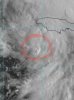
I think we might have a LLC just SW of Jamaica just solely based on my untrained eye of satellite images
With more visible images now it looks like there could be something around 78.5 and 16.5 give or take a little.
With more visible images now it looks like there could be something around 78.5 and 16.5 give or take a little.
Where are you seeing those numbers at?
Shaggy
Member
Where are you seeing those numbers at?
Nothing official just my observations of the low clouds. Could also be a MLC over to the western tip of Jamaica as well.

Cbmatt2408
Member
That loop is mesmerizing. You can see the lower level rotation occurring and a ton of convection all over. Looks like it may be starting to organize a little.Nothing official just my observations of the low clouds. Could also be a MLC over to the western tip of Jamaica as well.

Agreed. I wonder how close this might develop to Jamaica......I think the East shift, Short term only, in the models will continue today.I have a feeling that recon will find a td today. I find how the convection propagates northward on the IR images interesting
Shaggy
Member
That loop is mesmerizing. You can see the lower level rotation occurring and a ton of convection all over. Looks like it may be starting to organize a little.
Yeah you.can clearly see the low cloud field has a solid spin starting. Exactly where that LLC is forming is a bit muddy due to so much convection. I would not be surprised to see a center reform under the deeper convection either.
Shaggy
Member
BHS1975
Member
The GFS is the worst possible track for NO. Right over the loop current on the way. The only thing that might keep it from going nuclear is the forward speed.
Sent from my iPhone using Tapatalk
Sent from my iPhone using Tapatalk
Brent
Member
Here we go
| NHC will initiate advisories on Tropical Depression Nine, located over the west-central Caribbean Sea, at 1100 AM EDT (1500 UTC). |
IMO, it could be....however there is plenty of inflow going into what's going on N of Jamaica as well.This is wear my aging eyes suspect the LLC is developing based on visible.
Last nights Euro also showed it surrounded in a very thick plume of moisture as it gets ready to make landfall.
Things look a little "messy" out ahead of 99L. There are few upper trof's/ULL that will really be interesting to see how it plays out with 99L
