SnowwxAtl
Member
Comparing 0z & 06z GFS, 6z did some in a tid weaker then 0z. ICON remain close to its wallet with strength and eastward track from NHC trajectory and cone zone.
All the ensemble means are west like NHC track as well.I’d hate to be NHC right now, on one hand the Euro which is dang hard to beat at this stage and then again you have above.
Becoming worse and worse for ATL metro.
Depends on how deep that turn becomes.Becoming worse and worse for ATL metro.

Dang won’t take much more for Upstate SC to be out of it completely. Pretty hilarious and a sign of things to come for winter.
FL winds are just under hurricane strength too. Shouldn't be long before she's a 1.recon shows 981 mb
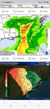
16-20 for the southern escarpment. That’s not good.Latest forecast from WPC showing swath of double digit rainfall totals.View attachment 151730
Dang won’t take much more for Upstate SC to be out of it completely. Pretty hilarious and a sign of things to come for winter.
Right on schedule with HWRF and HMON forecast at the gate.LOCATION...21.1N 86.2W
ABOUT 60 MI...100 KM ENE OF COZUMEL MEXICO
ABOUT 100 MI...160 KM WSW OF THE WESTERN TIP OF CUBA
MAXIMUM SUSTAINED WINDS...70 MPH...110 KM/H
PRESENT MOVEMENT...NW OR 325 DEGREES AT 9 MPH...15 KM/H
MINIMUM CENTRAL PRESSURE...979 MB...28.91 INCHES
