• Hello, please take a minute to check out our awesome content, contributed by the wonderful members of our community. We hope you'll add your own thoughts and opinions by making a free account!

Tropical Hurricane Helene

two_atl_7d0 (1).png

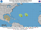
3. Northwestern Caribbean Sea and Southern Gulf of Mexico:
A broad area of low pressure could form by the early to middle
part of next week over the northwestern Caribbean Sea. Thereafter,
gradual development of this system is possible, and a tropical
depression could form as the system moves slowly to the north or
northwest over the northwestern Caribbean Sea and into the southern
Gulf of Mexico through the end of next week.
* Formation chance through 48 hours...low...near 0 percent.
* Formation chance through 7 days...medium...60 percent.
 
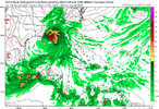
Some colossal changes at 500mb on the GFS with the trough but the end result isn’t too different. It is further east into Panama City though
IMG_0194.png
 
0Z:

Euro: E of 12Z, which had hit Mobile 9/29 at 989; 0Z hits Apalachicola 9/29 at 984 mb

GFS: just SE of Panama City late 9/27 at 979

CMC: E LA 9/27 981

ICON: C Gulf moving N 965 9/28

UK: 200 miles SSE of LA/TX border 1000 mb moving NNW late 9/27
 
Last edited:
Back
Top