These two storms gave me 5 inches in Henry County last year!
-
Hello, please take a minute to check out our awesome content, contributed by the wonderful members of our community. We hope you'll add your own thoughts and opinions by making a free account!
You are using an out of date browser. It may not display this or other websites correctly.
You should upgrade or use an alternative browser.
You should upgrade or use an alternative browser.
Misc General Banter Thread
- Thread starter Rain Cold
- Start date
GeorgiaGirl
Member
Yeah, I would've said too difficult until that happened, now I think it's a case where you have to really get into the ice box and that kind of setup can easily break people's hearts that are not as deep in the south.
Not sure these maps are completely correct btw. The 1" should cover most of my county for storm #1 except for the far southern part, though my dad did imply that it snowed heavily for a brief period as far south as where I'm located (probably 0.25-0.5 down there and then around the airports it was about an inch). I "think" storm #2 is correct but the numbers are confusing me a little.
I may be changing my chase destination to the Sierra mountains.
Thanks for these maps. The 3” for my area matches my 2.9” well. But ~2.5” of it was sleet, which made it even more amazing! That along with continued cold gave it great staying power. It took ~5 days to melt! The 2018 mix was more snow than sleet and totaled ~2”, but it stuck ~as long despite a good bit less water content because temps were a good bit colder the days prior and it was a bit colder averaged out during the storm.
Drizzle Snizzle
Member
Drizzle Snizzle
Member
SnowNiner
Member
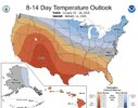
Looks very toasty from Jan 20-26View attachment 182760
Wedging opportunity right there. We ridge a bit but I bet we wedge too making us cold a few days.
Trolling in banter thread is still trolling. Kinda getting old
packfan98
Moderator
Are you going ALL IN???UKMET ens (MOGREPS-G) trend View attachment 182766
Here comes the string of deleted posts.Trolling in banter thread is still trolling. Kinda getting old
NBAcentel
Member
The UKMET is certainly one of those thorns on the arse models you wouldn’t want showing a bad solution if we had something to track, it’s certainly interesting seeing it the other way aroundAre you going ALL IN???
packfan98
Moderator
and the trend with ensemble support is pretty astounding. I don't know how many members it has and the perturbations used. Does the Mogreps always follow the op closely?The UKMET is certainly one of those thorns on the arse models you wouldn’t want showing a bad solution if we had something to track, it’s certainly interesting seeing it the other way around
rburrel2
Member
So in the end. The system 1 cut off will never make it south of Canada? lol.
Yeah weird seeing it bite so hard on this one. So far ICON has been the one not to budge at all -- if we start seeing it move in this direction I'll be impressed.The UKMET is certainly one of those thorns on the arse models you wouldn’t want showing a bad solution if we had something to track, it’s certainly interesting seeing it the other way around
rburrel2
Member
I’d say more than half of our 2+ inch storms are completely lost in the 4-7 day timeframe. This one has that feel to me, just a slight adjustment and boom, widespread sig. snow.
Naw, I don't have time for that just thought I'd troll the trollHere comes the string of deleted posts.
WolfpackHomer91
Member
I live in Mooresville NC im probably 35 miles N of CLT and I got 1.5 out of that and im 55 miles from VA lolYeah this is almost in Virginia. Of course it can snow there in February. You can’t compare the NC/VA border to most of the south.
Exactly dude lives in South GA. Climate is in no way similar to 90% of the board, that same bs he trolls with has us at worst just avg. It is just annoying bc a new lurker or something may see that and not understand who it is or where he isTrolling in banter thread is still trolling. Kinda getting old
Drizzle Snizzle
Member
My average winter temps are only 5 degrees warmer than Atlanta. I’m not in Key West.I live in Mooresville NC im probably 35 miles N of CLT and I got 1.5 out of that and im 55 miles from VA lol
Exactly dude lives in South GA. Climate is in no way similar to 90% of the board, that same bs he trolls with has us at worst just avg. It is just annoying bc a new lurker or something may see that and not understand who it is or where he is
NoSnowATL
Member
Drizzle snizzle is a special member to this site. I did like the Dewy Dan phase better tho.I live in Mooresville NC im probably 35 miles N of CLT and I got 1.5 out of that and im 55 miles from VA lol
Exactly dude lives in South GA. Climate is in no way similar to 90% of the board, that same bs he trolls with has us at worst just avg. It is just annoying bc a new lurker or something may see that and not understand who it is or where he is
WolfpackHomer91
Member
It is also hilarious to me how models are treated exactly like preseason AP votes in CFB or CBB. Yes..... the EURO ect is still probably the one you need on your side but I feel like it could lose ten straight and people would still rank it based off of first impressions and in this simili "Preseason AP Votes". It is like MIA in football prior to this year..... every year start at top 10-15 do nothing but then rattle off a few wins and shoot up in peoples minds. Meanwhile your GFS or Canadians of the world are unranked but start 10-0 and only make it to like 17 bc of first impressions and predetermined opinions
HailCore
Member
Last year leading up to both the Jan 10 and 21 storms, it basically disappeared off the ops on certain runs to cold and dry or trace amounts at about the same 4-6 day range. But then again, the ensemble means for both the GFS and Euro were consistently decent while this timeframe is not doing so well on there. Still got some time though and maybe the 12z suite from today starts a positive trend.I’d say more than half of our 2+ inch storms are completely lost in the 4-7 day timeframe. This one has that feel to me, just a slight adjustment and boom, widespread sig. snow.
Welcome back, Fro. It is time to bring this one home.
SnowNiner
Member
If this does turn back into a storm for this weekend, the UKMET will win comeback model of the year.
This feels like a classic GFS happy hour run upcoming. Hope I’m right
you jinxed it....on to the 0z GFS!This feels like a classic GFS happy hour run upcoming. Hope I’m right
Nobody cares about the gfs it don’t even know what’s gonna happen tomorrow.
UKMET save us.
Yeah my bad. Oh well!you jinxed it....on to the 0z GFS!
- Joined
- Jan 23, 2021
- Messages
- 4,602
- Reaction score
- 15,197
- Location
- Lebanon Township, Durham County NC
I unironically trust the GFS more than the ukmet based on its history and the fact that this weekend will be a nw flow event, its not feasible to get several inches east of the WEST facing mountains with that setup.

We gonna rage soon 
Pops
Member
Gfs looked like poopy!!oh well we hug Omer!!I guess..lol
Pops
Member
Gfs looked like poopy!!oh well we hug ukmet guess..lol
rburrel2
Member
For better or worse... the GFS these days is like looking at nogaps or CFS for guidance. It's a joke model.
I look at it too, because it's fun, but it is absolutely not relevant in forecasting.
I look at it too, because it's fun, but it is absolutely not relevant in forecasting.
We still got that 300hr storm, fams. Be patient yall act like yall haven’t had snow in 4 years. wait
Cad Wedge NC
Member
Yeah, no doubt it has become a 3rd rate model. Why even run it? When you get to the timeframe where it becomes accurate, that is already within the range of all the high-resolution models. That makes it essentially worthless.For better or worse... the GFS these days is like looking at nogaps or CFS for guidance. It's a joke model.
I look at it too, because it's fun, but it is absolutely not relevant in forecasting.
I  packfann98
I ain’t seen so many people be excited about 300hr sprinkles in my life! Ride the Brad P trainWe still got that 300hr storm, fams. Be patient yall act like yall haven’t had snow in 4 years. wait
packfan98
Moderator
We’ve been doing this together now for at least a dozen years or more, right?Ipackfann98
I miss Storm5 
Did he take his half of the private jet and leave??
Did he take his half of the private jet and leave??


