Six Mile Wx
Member


Do you have any pictures of the meanFWIW the 06z GEFS looks much snowier and colder than the operational hmmmm??

That’s the past, one will get through eventually. Maybe this one can make him a believer again.------------- mentioned on Twitter yesterday that CLT has received 85” of modeled snow this season (in the 7-10 day range) that resulted in 0” come verification.
Good luck reeling this one in.
Do you have any pictures of the mean


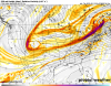
The only EPS picture I have is this. ONLY GOES OUT TO HR 144 RIGHT BEFORE SYSTEM MOVES INAnybody have the 6z eps yet? Did the trend of separating the sw energy continue?

Anybody have the 6z eps yet? Did the trend of separating the sw energy continue?


Is this good or bad


6z Euro, unless I'm misreading it, also looked better with the energy:
12z NAM looked similar too:
That NAM run would cutoff if you extrapolated it forward
So this is over isn’t it
Sent from my iPhone using Tapatalk

Dude I know you are new here but comments like that the mods will reprimand you real quick for.
Sent from my iPhone using Tapatalk


Over half of sc gets snow with gfs. Accumulations may be significant I think
Sent from my iPhone using Tapatalk
.png")