Here's a ice map from the GFS. I think the Sandhills might have a few problems as far as ice accrual but for the majority of the state freezing rain will not be an issue. The low QPF totals keep most folks dodging a bullet there.

If that happens gonna be a thin strip of heavy snow just north of the transition line. Gotta get close enough to the fire to cook but not burnWarm nose out east trending stronger on the euro… I don’t buy how far SE it is with the heavier snow, that trend at 850mb makes me more confident. Gonna likely see QPF increase as the warm nose/warm air advection starts to be sniffed out further on the euro View attachment 170278View attachment 170277
Warm nose out east trending stronger on the euro… I don’t buy how far SE it is with the heavier snow, that trend at 850mb makes me more confident. Gonna likely see QPF increase as the warm nose/warm air advection starts to be sniffed out further on the euro View attachment 170278View attachment 170277

Something else to note is temps. It's way too toasty compared to reality. Even 6Z verified 5 degrees different with us at 25 here when it only has 30 or 32 modeled. Have to see how they go into tonight though because if we're colder than 37 N GA is probably more at risk than models show.HRRR way too dry, not surprising it still sucks in it's lr and has moisture issues. 3k NAM surprised me a little this morning and gives me pause but it has had some issues with nailing down extent of precip shield of late. NAM far cry from it's way over amped days of old since updates.
Love seeing euro continue to improve. Watching radar out west today and 12z runs, should help nail this down.

I noticed that as well. You would think this tilt would force more precip into the storm, but not really seeing much…yet.View attachment 170281
In doing so it keeps wanting to tilt this deformation band more SW-NE, so while the precip shield isn’t necessarily expanding northwestward, amounts are slowly taking a different orientation. Note: image is from the 0z run

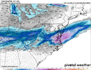
virginia beach jackpot, this is a top 5 snowfall for them probably, I think their all time is 18 inchesLatest National Blend of models favors north of HWY 64.
View attachment 170283
I’ve not had a chance to look at models this morning. Are the HRRR and NAM 3k still showing that line of thunderstorms in the Gulf?. If that’s the case it explains why those models keep getting dryer in WNC and the upstate. If there is a line of thunderstorms down there we need them to be oriented more SW to NE not WSW to ENE like they were showing last nightHRRR way too dry, not surprising it still sucks in it's lr and has moisture issues. 3k NAM surprised me a little this morning and gives me pause but it has had some issues with nailing down extent of precip shield of late. NAM far cry from it's way over amped days of old since updates.
Love seeing euro continue to improve. Watching radar out west today and 12z runs, should help nail this down.
Consistency is key for me GFS has been like this for days now. Is it right tho only time will tell the taleGFS been locked in on 3-5” for several runs now for GSO to RDU.
View attachment 170285View attachment 170286
They both do have that line and I'm sure that is part of the issue for western sections, it's a little earlier in it's run too so somewhat closer to it's accurate timeframe. For further east they both having a difficult time on location of the coastal low, HRRR way south and east, frankly it's not it's strong suit and the 3k NAM really jumpy with slp placement.I’ve not had a chance to look at models this morning. Are the HRRR and NAM 3k still showing that line of thunderstorms in the Gulf?. If that’s the case it explains why those models keep getting dryer in WNC and the upstate. If there is a line of thunderstorms down there we need them to be oriented more SW to NE not WSW to ENE like they were showing last night


 I
IYeah that does worry me some. It's only one doing that but it's the one thing it gets right more times than notThe NAM is a sleet fest for Raleigh.
Although it could be over amping things, this solution in general is pretty believable tbh
View attachment 170292
View attachment 170291I
It was showing a sleet fest for New Orleans, Florida and myrtle beach with that last one too at one point. Don't remember how far out it was but I remember telling NOLA snow weenies to enjoy their sleet storm. That obviously did not happen. While it could be right, I don't think it is and it's probably and outlierThe NAM is a sleet fest for Raleigh.
Although it could be over amping things, this solution in general is pretty believable tbh
View attachment 170292
View attachment 170291I
It may be wrong, but over the past 24 hours I don't think anything has been more consistent than the SREF-ARW core. As of now, this footprint and amounts most align with my forecast thoughts. As usual, Wake County is going to be one of the most difficult spots to pin down.FWIW, the 3z SREF came a little more in line with other modeling and sets the high end of what’s possible in my opinion.
View attachment 170280

The NAM is a sleet fest for Raleigh.
Although it could be over amping things, this solution in general is pretty believable tbh
View attachment 170292
View attachment 170291I
It was showing a sleet fest for New Orleans, Florida and myrtle beach with that last one too at one point. Don't remember how far out it was but I remember telling NOLA snow weenies to enjoy their sleet storm. That obviously did not happen. While it could be right, I don't think it is and it's probably and outlier
As I mentioned a couple days ago, the NAM was superior to the other models inside 48 hours with thermals on the Florida storm. If it shows sleet and all other models snow, don’t rule out a NAM coup.The NAM is a sleet fest for Raleigh.
Although it could be over amping things, this solution in general is pretty believable tbh
View attachment 170292
View attachment 170291I
I'd use the 3km NAM at this range.
Yeah the NAM could over amp things but it’s a totally different setup this time around. Your precip generation here is largely dependent on warm advection aloft. That’s why you have mixing issues with higher QPF on some models
")
Ok and it has already trended warmer with waa more of a northward push. Again, something to watch for sureI'd use the 3km NAM at this range.

Yeah even the EPS mean is trending north with the warm nose in ENC, that’s a Ens mean doing that which says a lotOk and it has already trended warmer with waa more of a northward push. Again, something to watch for sure
View attachment 170297
I'll be watching CC radar tomorrow evening and begging that line to stopYeah even the EPS mean is trending north with the warm nose in ENC, that’s a Ens mean doing that which says a lot