Fescue and Bermuda both for pre emergentThis early? Must be on fescue
-
Hello, please take a minute to check out our awesome content, contributed by the wonderful members of our community. We hope you'll add your own thoughts and opinions by making a free account!
You are using an out of date browser. It may not display this or other websites correctly.
You should upgrade or use an alternative browser.
You should upgrade or use an alternative browser.
Pattern Fab Feb
- Thread starter SD
- Start date
What are you using? Prodiamine for meFescue and Bermuda both for pre emergent
We were so close. Hit 80ºF for the official high at KATL, the 81ºF shown here is a rounded figure from official recordings done in ºC, so did not tie the all time monthly record of 81ºF. Impressively warm, dry February day, feels like October
packfan98
Moderator
Its too bad below 900mb is so warm most of the cams develop a nice area of light precip around here around 18z Sunday
NCHighCountryWX
Member
- Joined
- Dec 28, 2016
- Messages
- 700
- Reaction score
- 1,921


We use both Prodiamine and DimensionWhat are you using? Prodiamine for me
trackersacker
Member
 My outlook for the Southern Apps region
It’s not for us, but the 00z NAM did some NAM’ing tonight. 

The GFS is similar although a little less extreme. Meanwhile, in most of the areas with 30-40” on the NAM, the Euro and Canadian have 2-4”. USA against the world!
The GFS is similar although a little less extreme. Meanwhile, in most of the areas with 30-40” on the NAM, the Euro and Canadian have 2-4”.
USA against the world!Brent
Member
Blizzard warning for NYC already 
I was out early last night lol but 18z and 0z below. I'll post 6z if I get a chance, busy day ahead.@RBR71 did you get the WeatherNext 18z?

0z

Not much out there that gives me hope for more than a few wet flakes mixed in on precip exit. Oh well, maybe March holds a surprise
Stupid NAMNot much out there that gives me hope for more than a few wet flakes mixed in on precip exit. Oh well, maybe March holds a surprise
6zI was out early last night lol but 18z and 0z below. I'll post 6z if I get a chance, busy day ahead.
View attachment 194386
0z
View attachment 194387

CNCsnwfan1210
Member

The longer period of time any area can precipitate tomorrow and the sooner the low bombs the better the chance of a change over. I'm still skeptical given the depth of the warm air and the potential for light short duration precip but if any area will change over tomorrow it'll probably be from you over to moyockStupid NAM
What a ridiculous bomb on the 12z nams
My bad didn't have my glasses on but yes you are correct. It was early December 2018 in Marion NC. Early to mid December along with Early to mid March has brought good snows to the foothills. We got the cold up in Canada so let's roll the dice. I think WNC could see another decent event before spring.Where were you at that had 14 feet in 12hours? I think you meant 14" in 12 hours and 3' in 24.
GeorgiaGirl
Member
First time hearing thunder since last year this morning.
Upper MA/NE people have mixed feelings on the coming storm. Some are weenies who are passing out in excitement, others are just completely over it, especially with January's storm having just melted.
Upper MA/NE people have mixed feelings on the coming storm. Some are weenies who are passing out in excitement, others are just completely over it, especially with January's storm having just melted.
NCHighCountryWX
Member
- Joined
- Dec 28, 2016
- Messages
- 700
- Reaction score
- 1,921
&&
...THE FORECAST FOR ROAN MOUNTAIN AT 6285 FT...
...WINTER STORM WARNING IN EFFECT FROM MIDNIGHT TONIGHT TO MIDNIGHT
EST MONDAY NIGHT...
.TONIGHT...Cloudy. Patchy fog and dense freezing fog. Rain and snow
likely. Little or no snow expected. Lows in the mid 20s. West winds
10 to 15 mph, increasing to northwest 20 to 25 mph after midnight.
.SUNDAY...Cloudy. Patchy dense freezing fog. Snow showers likely.
Snow may be heavy at times. Snow accumulation around 6 inches. Highs
in the upper 20s. Temperatures falling into the mid teens in the
afternoon. Northwest winds 25 to 30 mph, increasing to 30 to 35 mph
in the afternoon. Gusts up to 51 mph. Wind chill values in the
single digits above zero.
.SUNDAY NIGHT...Mostly cloudy. Snow showers likely. Snow
accumulation around 3 inches. Lows in the lower teens. Northwest
winds 40 to 45 mph, increasing to 45 to 50 mph after midnight. Gusts
up to 69 mph. Wind chill values in the lower teens below zero.
.MONDAY...Mostly cloudy. Snow showers likely. Snow accumulation
around 1 inch. Highs in the upper teens. Northwest winds 45 to
50 mph, decreasing to 40 to 45 mph in the afternoon. Gusts up to
70 mph. Wind chill values in the lower teens below zero.
NBAcentel
Member
Probably don’t do to much with this given the ridging aloft but that’s a pretty stout high pressure showing up on modeling 


NCHighCountryWX
Member
- Joined
- Dec 28, 2016
- Messages
- 700
- Reaction score
- 1,921
Winter storm warning hoisted. Up to 10 inches
CZ033-220400-
/O.NEW.KGSP.WS.W.0002.260222T0500Z-260224T0500Z/
Avery-
Including the cities of Banner Elk, Ingalls, and Newland
150 PM EST Sat Feb 21 2026
...WINTER STORM WARNING IN EFFECT FROM MIDNIGHT TONIGHT TO MIDNIGHT
EST MONDAY NIGHT...
* WHAT...Heavy snow expected. Total snow accumulations mostly
between 2 and 6 inches, with amounts up to 10 inches possible
along the Tennessee border and in the high elevations.
* WHERE...Avery County.
* WHEN...From midnight tonight to midnight EST Monday Night.
* IMPACTS...The heavy snow will make many roads impassable and may
produce a few power outages due to the weight of the snow on tree
limbs and power lines. The hazardous conditions could impact the
Monday morning and evening commutes.
* ADDITIONAL DETAILS...Winds gusting as high as 50 mph could result
in areas of blowing snow and very low visibility Sunday night and
Monday.
PRECAUTIONARY/PREPAREDNESS ACTIONS...
Monitor the latest forecasts for updates on this situation.
Slow down and use caution while traveling.
If you must travel, keep an extra flashlight, food, and water in
your vehicle in case of an emergency.
&&
lexxnchloe
Member
Euro has a thin stripe of accumulating snow thru central NC tomorrow night
NCHighCountryWX
Member
- Joined
- Dec 28, 2016
- Messages
- 700
- Reaction score
- 1,921


Looks like the 12z Euro is folding towards a more GFS/NAM-esque major Mid Atlantic and SNE winter storm. Dare I say the GFS has led the way with this one (granted, it was probably too extreme and too far SW the other day, but the Euro and others were barely showing a storm onshore).
I think we are done here, but NE NC could pick up a coating or maybe even a couple inches if all aligns correctly (doubtful).

I think we are done here, but NE NC could pick up a coating or maybe even a couple inches if all aligns correctly (doubtful).


GeorgiaGirl
Member
Looks like the 12z Euro is folding towards a more GFS/NAM-esque major Mid Atlantic and SNE winter storm. Dare I say the GFS has led the way with this one (granted, it was probably too extreme and too far SW the other day, but the Euro and others were barely showing a storm onshore).
I think we are done here, but NE NC could pick up a coating or maybe even a couple inches if all aligns correctly (doubtful).
View attachment 194397
Yeah, presuming you do have areas up in the NE potentially threaten at least 20", it's a HUGE win for the GFS, I'd say. (which I took a second snap look lol and some of the areas to the east of the NYC limits are there)
It's so much of a win that some of the areas in the NE may not be quite as prepped this time since there is always more focus on the Euro. Apparently the stores around NYC are quiet in spite of the Blizzard Warning called for them...
LukeBarrette
im north of 90% of people on here so yeah
Meteorology Student
Member
2024 Supporter
2017-2023 Supporter

A quick inch or two here is very possible
Tsappfrog20
Member
Yea the NWS has putt some graphics out saying they think a trace or so NE of the triangle
Sent from my iPhone using Tapatalk
lexxnchloe
Member
Maybe NENC will get 1-3
JP152
Member
Blizzard warnings on the Virginia Eastern Shore...lolMaybe NENC will get 1-3
rburrel2
Member
Would be nice if we found a way not to waste this.


Dewpoint Dan gonna hate this one. Earliest last freeze in jeopardy 
NBAcentel
Member
Digging into this look more probably just a few moves away from cooking something up at day 10 


Bigedd09
Member
Digging into this look more probably just a few moves away from cooking something up at day 10 View attachment 194411View attachment 194412View attachment 194413View attachment 194414View attachment 194415
Virginia cooking this winter. Insane
Sent from my iPhone using Tapatalk
The spring….well, practically summer…wx the last 2 days here (85 and 86 record highs at KSAV, both exceeding forecasts of lower 80s) is about to come to a very welcomed abrupt end. After also a possible record high minimum for today (won’t know til midnight), the high on Mon may be close to 40 colder and the low on Tue will be close to 40 colder with it flirting with the record 25! So, pseudo-summer record highs to mid-winter conditions/record lows in the span of just 48 hours! It doesn’t get much more dramatic than this in the temperature swing dept and is the main reason winter is the most interesting season to track.
iwantsouthernsnow123
Member
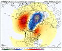
Stratospheric Warming is starting to get serious. We've got to watch closely where these PV lobes end up going. It is possible that this ends up only affecting Europe. However, it is also possible with the right scenario that this impacts the US too.
What is going on in this loop, at the current timeframe we are at right now, you see a big of a U Shape forming around the lower heights area. As it progresses, you start seeing that U Shape essentially filter in the middle. This is where you then notice 2 lobes split. This means the Polar Vortex(PV) is extremely unstable and is likely to filter southward in at least somewhere. Where is the question. This is a sneaky situation ongoing and could result in very cold air somewhere, potentially the lower 48.
Lots of interesting stuff going on behind the scenes, there is a chance we have quite a start to march ahead of us.
Disclaimer: AIFS is not the only model showing this, it's just one i used as a reference. This is actively occurring
Attachments
Last edited:
If hi res NAM is correct, could still be fun for a few hours around here tomorrow evening

Weathernext fairly locked in on slight chance of measurable snowfall, probably grassy areas and car topper at best. But feel confident in seeing some snow fly now

Weathernext fairly locked in on slight chance of measurable snowfall, probably grassy areas and car topper at best. But feel confident in seeing some snow fly now
Could be breezy too
