• Hello, please take a minute to check out our awesome content, contributed by the wonderful members of our community. We hope you'll add your own thoughts and opinions by making a free account!

Effects of a Warmer World on Southeast Snow Climo

superjames1992

Rates Will Overcome All
Member
2024 Supporter
Joined
Dec 15, 2019
Messages
4,330
Reaction score
9,043
Location
Durham, NC
Something I was thinking about recently is how our snowfall in the Southeast will be affected by warming temperatures globally. Has there been any deep analysis done on this?

I don’t want this to turn into a conversation about the merits of global warming/climate change, and whether it is manmade, and if so how much of it is manmade versus natural. There’s another thread for that. My topic in this thread is, assuming a future warming world, regardless of cause, how will the Southeast’s snow climo be affected? Will regular seasonal snowfalls be a thing of the past in the NC Piedmont by late century? Will kids growing up in Macon, GA late century never see snowfall in their backyards?

For example, assuming IPCC predictions are somewhat accurate (debatable, but for the sake of this argument), it’s not inconceivable that Raleigh could have average temperatures that are somewhat comparable to Macon, GA’s today by late century. However, I don’t imagine this would directly translate into the same snow climo as Macon circa 2020 given the geographical differences, storm tracks, etc. between the locations. For example, Raleigh and Charlotte circa 2020 have about the same January average temperatures, but Raleigh still averages around 50% more seasonal snow because of its superior snow geography; it is able to take advantage of coastals that Charlotte is too far west to get. It’s a similar story with Atlanta; even though Atlanta is only a couple degrees warmer than Raleigh and significantly higher in elevation, the city averages something like a third of Raleigh’s seasonal snowfall.

I may largely be restating the obvious here, but it’s just something I was thinking about and I’m not sure it’s something I’ve seen discussed on here before. How would a climate that is 5F warmer than today’s impact Raleigh’s snow climo? Charlotte’s? Atlanta’s? Would Birmingham basically be relegated to Gulf Coast-level snow climo in such a scenario? What about 10F? That would put Charlotte’s average January temperatures about comparable to the FL panhandle’s today. But would it truly snow as little as it snows in the FL panhandle today (where Tallahassee saw its first accumulating snowfall in 23 years in January 2018)?
 
Last edited:
I have no idea but 2010 to 2020 has gave me several big events over 12”. 90’s to 2009 was not as good. Maybe more moisture and warmer is better for us.
 
I feel like there is a bigger impact on summer convection pop up storms over the NC mtns. They have disappeared for many years. That’s what got me into weather but man the past 10 years have sucked! Must take a special pattern to get them daily for several weeks straight.
 
Something I was thinking about recently is how our snowfall in the Southeast will be affected by warming temperatures globally. Has there been any deep analysis done on this?

I don’t want this to turn into a conversation about the merits of global warming/climate change, and whether it is manmade, and if so how much of it is manmade versus natural. There’s another thread for that. My topic in this thread is, assuming a future warming world, regardless of cause, how will the Southeast’s snow climo be affected? Will regular seasonal snowfalls be a thing of the past in the NC Piedmont by late century? Will kids growing up in Macon, GA late century never see snowfall in their backyards?

For example, assuming IPCC predictions are somewhat accurate (debatable, but for the sake of this argument). it’s not inconceivable that Raleigh could have average temperatures that are somewhat comparable to Macon, GA’s today by late century. However, I don’t imagine this would directly translate into the same snow climo as Macon circa 2020 given the geographical differences, storm tracks, etc. between the locations. For example, Raleigh and Charlotte circa 2020 have about the same January average temperatures, but Raleigh still averages around 50% more seasonal snow because of its superior snow geography; it is able to take advantage of coastals that Charlotte is too far west to get. It’s a similar story with Atlanta; even though Atlanta is only a couple degrees warmer than Raleigh and significantly higher in elevation, the city averages something like a third of Raleigh’s seasonal snowfall.

I may largely be restating the obvious here, but it’s just something I was thinking about and I’m not sure it’s something I’ve seen discussed on here before. How would a climate that is 5F warmer than today’s impact Raleigh’s snow climo? Charlotte’s? Atlanta’s? Would Birmingham basically be relegated to Gulf Coast-level snow climo in such a scenario? What about 10F? That would put Charlotte’s average January temperatures about comparable to the FL panhandle’s today. But would it truly snow as little as it snows in the FL panhandle today (where Tallahassee saw its first accumulating snowfall in 23 years in January 2018).

Probably would need to dive into the hourly surface obs and remodel p-types for "event+5F". What are currently marginal/borderline events would become rain with +5F, but we still get a decent share of snow with temps well below freezing, with 5, 10, and sometimes 15 degrees or more to spare...I would think amounts from those get a boost with the higher PWATs. Overall a lot less snow, but even with 10F I don't think Charlotte would become the FL panhandle
 
The number of small events like tree toppers and flizzards have dramatically dropped which makes since as they would become cold rain events in a warming climate.


Sent from my iPhone using Tapatalk
 
When we start getting regular blue ocean events the Arctic will be dramatically warmer which would mean less cold air to tap into for storms.


Sent from my iPhone using Tapatalk
 
Something I was thinking about recently is how our snowfall in the Southeast will be affected by warming temperatures globally. Has there been any deep analysis done on this?

I don’t want this to turn into a conversation about the merits of global warming/climate change, and whether it is manmade, and if so how much of it is manmade versus natural. There’s another thread for that. My topic in this thread is, assuming a future warming world, regardless of cause, how will the Southeast’s snow climo be affected? Will regular seasonal snowfalls be a thing of the past in the NC Piedmont by late century? Will kids growing up in Macon, GA late century never see snowfall in their backyards?

For example, assuming IPCC predictions are somewhat accurate (debatable, but for the sake of this argument), it’s not inconceivable that Raleigh could have average temperatures that are somewhat comparable to Macon, GA’s today by late century. However, I don’t imagine this would directly translate into the same snow climo as Macon circa 2020 given the geographical differences, storm tracks, etc. between the locations. For example, Raleigh and Charlotte circa 2020 have about the same January average temperatures, but Raleigh still averages around 50% more seasonal snow because of its superior snow geography; it is able to take advantage of coastals that Charlotte is too far west to get. It’s a similar story with Atlanta; even though Atlanta is only a couple degrees warmer than Raleigh and significantly higher in elevation, the city averages something like a third of Raleigh’s seasonal snowfall.

I may largely be restating the obvious here, but it’s just something I was thinking about and I’m not sure it’s something I’ve seen discussed on here before. How would a climate that is 5F warmer than today’s impact Raleigh’s snow climo? Charlotte’s? Atlanta’s? Would Birmingham basically be relegated to Gulf Coast-level snow climo in such a scenario? What about 10F? That would put Charlotte’s average January temperatures about comparable to the FL panhandle’s today. But would it truly snow as little as it snows in the FL panhandle today (where Tallahassee saw its first accumulating snowfall in 23 years in January 2018)?
This is a question I’m hoping to start getting at with my winter storm archive that extends back to 1895 and is currently incomplete after 1952
 
I read somewhere that as the arctic warms there will tend to be more blocking episodes. Even as the world warms some places will cool slightly. Or with blocking, at least get more favorable storm tracks --> As you talked above, maybe we will get larger snow snowstorms but less big ice storms. **coincidence or maybe it's related, but the past years (excluding last) have given me large one off ~12' snow storms but very little freezing rain events.
 
I read somewhere that as the arctic warms there will tend to be more blocking episodes. Even as the world warms some places will cool slightly. Or with blocking, at least get more favorable storm tracks --> As you talked above, maybe we will get larger snow snowstorms but less big ice storms. **coincidence or maybe it's related, but the past years (excluding last) have given me large one off ~12' snow storms but very little freezing rain events.

Yeah but once the Arctic gets to the point where its ice free most of winter all blocking will do is get you a chilly rain.


Sent from my iPhone using Tapatalk
 
I read somewhere that as the arctic warms there will tend to be more blocking episodes. Even as the world warms some places will cool slightly. Or with blocking, at least get more favorable storm tracks --> As you talked above, maybe we will get larger snow snowstorms but less big ice storms. **coincidence or maybe it's related, but the past years (excluding last) have given me large one off ~12' snow storms but very little freezing rain events.
I started hearing that after the blocking in 09/10. But since then we haven't been able to buy blocking in winter so I'm not sure I agree with less ice equals more blocking.
 
There's a massive difference between having ice reflecting the light and open water soaking up tons of heat and releasing it in the winter.


Sent from my iPhone using Tapatalk
 
I was looking at this a few weeks ago and came across this. North Carolina has got the shaft this last decade.


View attachment 57814
That's interesting. RDU airport has not had a single winter break 10" total since 2003-04 so this is believable. Our yearly snowfall climo is about 6" but in recent years it hasn't been too uncommon to have less than 1-2". BHS1975 has a point about the lack of small events lately, both 2018-19 and 2019-20 had the one winter storm and nothing else.
 
Yeah but once the Arctic gets to the point where its ice free most of winter all blocking will do is get you a chilly rain.


Sent from my iPhone using Tapatalk
I don’t see any way the arctic becomes mostly ice free in winter . Especially on the North American side where due to the land masses it makes for less open ocean , meaning easier to freeze over . Summer MAY one day be ice free if this warm period gets there , buts that’s only summer .
 
I don’t see any way the arctic becomes mostly ice free in winter . Especially on the North American side where due to the land masses it makes for less open ocean , meaning easier to freeze over . Summer MAY one day be ice free if this warm period gets there , buts that’s only summer .

It's a positive feedback as you get more open water it soaks up more heat and sunlight which makes it take longer to freeze in the winter. You end up burning the candle at both ends. You be left with a small patch of sea ice in Northern Greenland.


Sent from my iPhone using Tapatalk
 
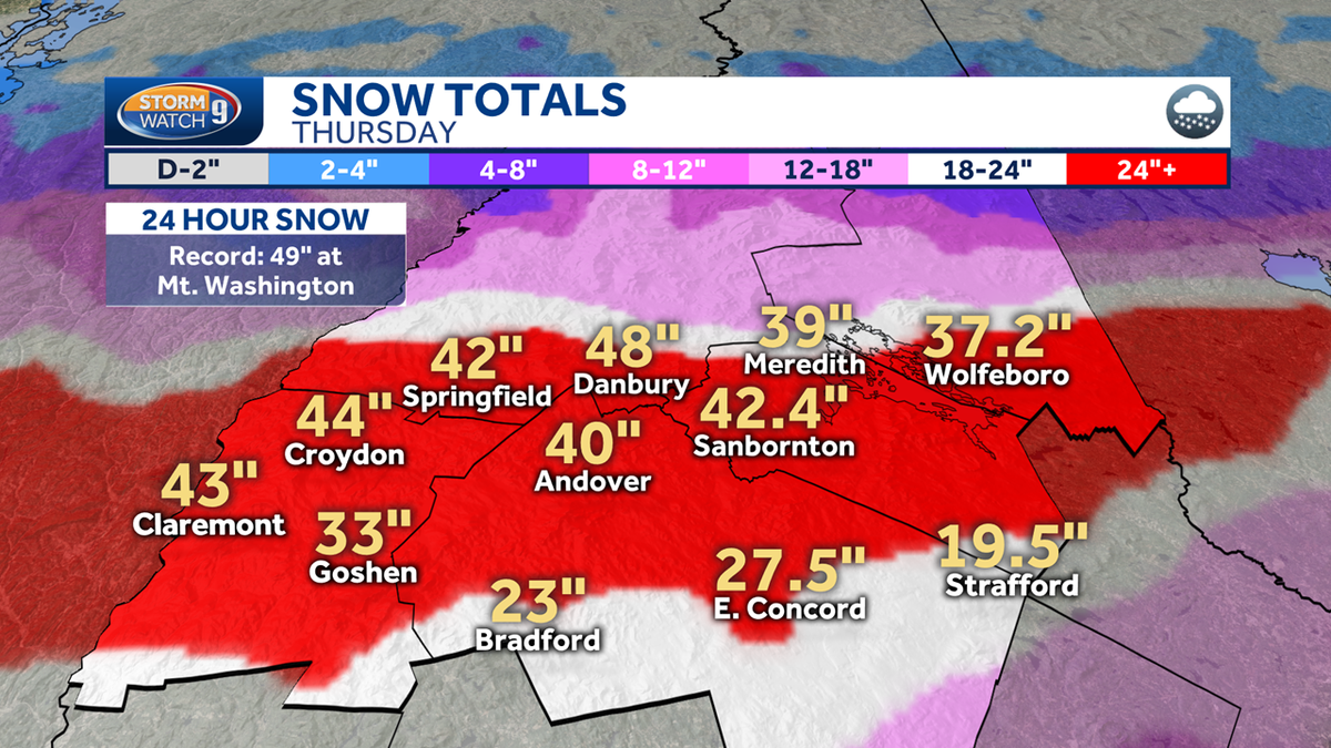
I feel like this belongs in this thread, though it's about the NE not the SE. This highlights the secondary effect of a warmer climate on snowfall: warmer SSTs --> more water vapor in the atmosphere --> heavier precipitation during more marginal events. For regions with plenty of cold air to begin with (like Upstate NY and interior New England, which cashed in bigly on 700 mb frontogenesis this storm), this means that very intense snow rates are more achievable. However, I'm concerned that the SE has too marginal of a baseline temperature to begin with for this to play in our favor, except on the very rare and extreme setup (I don't think we've seen storm that fits that bill post-2000, though). This is consistent with what we've seen over the past decade, according to what @olhausen posted.

Maybe our snowfalls will become more concentrated in a few large events, while smaller events become harder to come by. That's something I'd be curious to see from your archive @Webberweather53.


Yeap the rich get richer.


Sent from my iPhone using Tapatalk
 
Back
Top