-
Hello, please take a minute to check out our awesome content, contributed by the wonderful members of our community. We hope you'll add your own thoughts and opinions by making a free account!
You are using an out of date browser. It may not display this or other websites correctly.
You should upgrade or use an alternative browser.
You should upgrade or use an alternative browser.
Severe DEEP SOUTH Severe Weather threat 18-20th
- Thread starter Xtreme Weather
- Start date
-
- Tags
- hail severe weather tornado
- Status
- Not open for further replies.

jaymackd3
Member

Looks like our first real threat of the year.
ForsythSnow
Moderator
Looks like it's going to be intense watching the storms as they roll in tomorrow. Hoping for the wedge to destroy the tornadic ones as they get close to here.
This is an interesting setup for sure. Shear is less here, but cape values are very impressive for March.
jaymackd3
Member
Yeah it has my attention given that the worst of it appears at the moment over my area, but we are still out a ways from really seeing how things develop. Definitely worth keeping an eye on. Eagerly awaiting the next outlook from the SPC in about 25-30 min.Looks like it's going to be intense watching the storms as they roll in tomorrow. Hoping for the wedge to destroy the tornadic ones as they get close to here.
Bama Ravens
Member
New Day 2 Convective Outlook. They’ve pulled the enhanced risk west some, which makes sense, as storm initialization looks like it may take place further west.

I wouldn’t be surprised if the ENH gets expanded south into AL and west and central GA later


 It’s the 3KM NAM so take it with a grain of salt, but it’s got a pocket of strong winds at 850mb moving through. It actually gets a bit stronger as it moves thru AL and then into GA
B
Brick Tamland
Guest
Woah, looks bad for northern Arkansas and southern Tennessee.
BPATL
Member
Looks like the ATL could have some major issues????.
I don’t know. The wedge kind of holds until very end. Def possible thoLooks like the ATL could have some major issues????.
ForsythSnow
Moderator
Latest SPC update looks worse. The wedge may not save us after all. Either that or it's going to be a classic case of the SPC predicting worse than what comes to reality.
W
WeatherLC
Guest
I don't know the wedge usually does save us, and looking at the NAM doesn't look like the dewpoints get out of the 50's for our area. Might be enough for some elevated storms thoughLatest SPC update looks worse. The wedge may not save us after all. Either that or it's going to be a classic case of the SPC predicting worse than what comes to reality.
ForsythSnow
Moderator
Latest NAM puts the dewpoints north enough to put Forsyth in the 60s before the storms arrive. I just read FFC's discussion and they seem to be going for a strong wind and large hail risk and low tornado risk. Here's the part about tomorrow:I don't know the wedge usually does save us, and looking at the NAM doesn't look like the dewpoints get out of the 50's for our area. Might be enough for some elevated storms though
As vigorous shortwave moves east over TN valley, broad and
unusually strong westerly flow to the south remains in place. In
my experience with severe weather forecasts both here and in the
southern plains, this pattern has a great deal of potential to
produce atypically high instability and very strong deep vertical
wind shear with supercells the dominant mode. It has been over a
year since this area has seen supercell storms of this magnitude
(Jan 22 2017). Large hail and a few tornadoes will be likely.
Given MLCAPE values 2000-2500 J/kg and 0-6km bulk shear of
60-70kts, hail will likely be much larger than the Jan 2017 event
with sizes of 2 to 3 inches likely. If there is a bright side to
this story, it could be the low level shear, 0-1km bulk shear is
only progged of 30-35kts. This is still quite strong and should be
sufficient for a few tornadoes, but unlikely to see the larger
/long-tracked tornadoes that we saw with the Jan 2017 event or
other notable supercell-based tornado events and outbreaks.
Interestingly, CIPS top 15 analogs based on 00Z NAM valid 00Z Tue
do not contain any events in the last 10 years, so could be some
analogs with lower storm report density and thus lower analog
probabilities. Top analogs is Apr 3 1998 which produced widespread
hail over north GA but other dates have hit or miss coverage of
reports and not too many tornado events though there area some.
What’s the red stuff? Heading into upstate S.C. from GA?View attachment 4565 View attachment 4566 View attachment 4567 View attachment 4568 View attachment 4569 It’s the 3KM NAM so take it with a grain of salt, but it’s got a pocket of strong winds at 850mb moving through. It actually gets a bit stronger as it moves thru AL and then into GA
The tornado threat depends on how much mixing takes place with the shallow boundary layer moisture. That will be a game time call.
gawxnative
Member
One also has to keep in mind the posibility of discrete cells interaction with the wedge boundry..I don’t know. The wedge kind of holds until very end. Def possible tho
BPATL
Member
Their is no wedge today, 75 in ATL..
It’s 78 degrees in GSP area today, but tomorrow highs are supposed to be in the 50s. So wedge is coming. Will save the Upstate, but N Ga should be in the crosshairs tomorrowTheir is no wedge today, 75 in ATL..
FFCVery difficult call for Monday afternoon as some models indicate
low clouds and stable conditions will stay with the entire area
for the balance of the day. But there is a very sharp instability
gradient with in excess of 2000 J?KG just along and south of our
southern CWA border. Shear not the best but sufficient for some
rotating discreet cells should activity be able to develop across
the southern tier.
Final wave which looks to be of the most concern will be Monday
evening into the first part of the overnight period. Even
instability associated with this feature is less in the models
than this time a few days ago. But with positive CAPE values, feel
activity that develops over Alabama will be able to maintain
itself over the local area and take advantage of very strong shear
values to produce strong to severe storms. Pretty much everything
on the table for this one including damaging winds, isolated
tornadoes and large hail. Some hi res guidance wants to weaken
this feature as it gets south of the metro but thinking this may
be premature given similar events in the past and will advertise
severe risk well into Central GA for this one.
 18z NAM steady as she goes. Could be a big day tomorrow!
Xtreme Weather
Member
Geez significant

Explain this to us in dummy terms. Lol. I don’t know how to read that lolGeez significant
View attachment 4574
It means that there could be strong tornadoes in AL.Explain this to us in dummy terms. Lol. I don’t know how to read that lol
Phillip l
Member
Wow, this looks like it may be a rough one. I’m hoping that the NWS prediction of the line falling apart after Atlanta is correct. The one thing worse than severe weather is over night severe weather! I’m thankful that I have the storm shelter installed now, I’ll make sure that the kids are ready to get up and get out tomorrow night, hopefully it turns out better than it’s looking so far.
Xtreme Weather
Member
Best place to start is here very informative with photosExplain this to us in dummy terms. Lol. I don’t know how to read that lol
https://www.weather.gov/source/zhu/ZHU_Training_Page/convective_parameters/skewt/skewtinfo.html
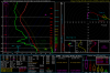
Nasty sounds Xtreme just posted from the 18Z NAM. Here is Huntsville's valid 0Z (7pm) as storms begin to fire up...

Also here is KATL 06Z valid 2am out ahead of the storms tracking into Georgia.

Going to be essential for those in N Ga, especially NE of Atlanta to see where the wedge sets up. Nocturnal tornado threats are not fun by any means.
0-3km EHI...0Z over Alabama.

Also here is KATL 06Z valid 2am out ahead of the storms tracking into Georgia.
Going to be essential for those in N Ga, especially NE of Atlanta to see where the wedge sets up. Nocturnal tornado threats are not fun by any means.
0-3km EHI...0Z over Alabama.
Attachments
Widespread 3000-3500 sbcape on the 0z WRF.

Widespread 3000-3500 sbcape on the 0z WRF.
That said the WRF ARW isn't nearly as bullish.
For North Georgia, the 0Z 12KM NAM brings 60F dewpoints further N/NE this run bringing in 1000+ J/KG CAPE through Gwinnett, into Forseyth, North Fulton County by 6Z Tuesday morning. The 3KM NAM not as bullish with CAPE through ATL Metro as 12km run.


Atlanta area sounding 06Z Tues from 12KM NAM.
Atlanta area sounding 06Z Tues from 12KM NAM.
Pick your model, you have the 12km NAM that looks nasty, all three WRFs point to North AL/GA and southern TN, and the nearly always bad 3km NAM which pops a small complex and poos out the threat for most of the area.
Lovemesomesnow
Member
Did I forget to pay my dues???? Appears to be the first real severe threat and the last post about it was around 2pm Sunday...... have I missed something???? Sure wanted to know what you guys thought. Since it says only 2 people are on this thread I'm assuming I'm lost.


Latest from the NWS Morristown TN
Did I forget to pay my dues???? Appears to be the first real severe threat and the last post about it was around 2pm Sunday...... have I missed something???? Sure wanted to know what you guys thought. Since it says only 2 people are on this thread I'm assuming I'm lost.
There have been several informative replies containing information posted after 2pm Sunday. Not sure if you can see them? This topic is not talked about as widely as snow because this weather event has the capability to decimate peoples livelihoods in a matter of minutes. So it’s generally the experts who post information. Not as much banter and useless posts in these threads. It’s one of those things that leave us in awe. I live in NW GA and all I can do is be aware of my surroundings tomorrow.
Brent
Member
still enhanced on the day 1
New Day 1

Day 1 Convective Outlook
NWS Storm Prediction Center Norman OK
0100 AM CDT Mon Mar 19 2018
Valid 191200Z - 201200Z
...THERE IS AN ENHANCED RISK OF SEVERE THUNDERSTORMS PARTS OF
TN...NORTHEAST MS...NORTHERN AL...AND NORTHWEST GA...
...THERE IS A SLIGHT RISK OF SEVERE THUNDERSTORMS SURROUNDING THE
ENHANCED RISK FROM THE TENNESSEE VALLEY TO THE SOUTHEAST STATES...
...THERE IS A MARGINAL RISK OF SEVERE THUNDERSTORMS SURROUNDING THE
SLIGHT RISK FROM THE MID-SOUTH AND SOUTHERN KY TO NORTHERN FL...
...SUMMARY...
Tornadoes (some strong), very large hail, and damaging winds are
expected across parts of middle Tennessee into northeast
Mississippi, northern and central Alabama to western Georgia.
Severe storms will be possible into southern Georgia and northern
Florida.
...Synopsis...
A compact closed cyclone and attendant shortwave trough will weaken
this forecast period as this system remains progressive, reaching
the lower Ohio and Tennessee Valleys by 20/00Z and into the upper
Ohio Valley by 12Z Tuesday. Meanwhile, a pair of shortwave troughs
and accompanying midlevel jets is expected to phase across the
southern Plains this afternoon into the evening, with further
amplification of this trough into the middle Mississippi Valley to
the northwest Gulf Coast region. A surface low, attendant to the
lead trough, will track from northeast OK to western middle
Tennessee by late this afternoon (by 21Z), with a cold front
extending southwest through northeast MS to southern LA. At 12Z
today, a warm front should extend through central AR and MS into
southern AL/GA. An increase in southwesterly winds across the lower
Mississippi and Tennessee Valleys to the Southeast States will
result in a moistening warm sector as the warm front advances to the
northeast. This boundary should extend from the surface low in
middle TN south-southeast through northern and central AL to
south-central GA by mid-late afternoon, before advancing farther
northeast tonight.
...TN/northeast MS/AL/northern and western GA...
Elevated showers and thunderstorms are expected to be ongoing at the
start of D1 within a zone of warm advection and strong forcing for
ascent attendant to a strong southwesterly low-level jet and the
lead compact shortwave trough moving through southern MO and AR. As
the deep-layer ascent spreads east into the lower Tennessee Valley
this morning to early afternoon, the early day convection will shift
into the Mid-South, likely delineating the northwest extent of
stronger destabilization. Surface dew points in the 60s and
steepening lapse rates will result in moderate instability across
the warm sector.
New storm development is expected by mid afternoon in western middle
TN into northeast MS as the surface low and cold front reach these
areas. This will coincide with strong forcing for ascent spreading
across the western extent of moderate instability. Strengthening
deep-layer winds (westerly at 50-70 kt in the 500-700-mb layer and
southwesterly at 40-50 kt at 850 mb shifting across MS into AL) this
afternoon will prove favorable for supercells. Given effective SRH
will exceed 300-400 m2/s2, a strong tornado or two will be possible
from parts of middle TN into northeast MS, northern AL and northwest
GA late this afternoon into the early evening, as the cold front
advances east. The favor thermodynamics and strong bulk shear will
support very large hail, as well.
Farther south across central into southeast AL, organized storms
including supercells will prove favorable for all severe hazards as
activity forms along the warm front this afternoon.
...Southern and eastern GA into northern FL...
Weak height falls across this region where the environment should
become moderately unstable may prove favorable for thunderstorm
development. Strengthening deep-layer westerlies across this region
will result in favorable shear for organized storms producing all
severe hazards into the early evening.
..Peters/Gleason.. 03/19/2018
- Status
- Not open for further replies.