I would also like to note that the euro isn't wet enough either. :| ugh; I was afraid of this. this is a situation where I am hoping for a change, but the GEFS members, Euro, and now the Canadian, within day 6 & 7.
-
Hello, please take a minute to check out our awesome content, contributed by the wonderful members of our community. We hope you'll add your own thoughts and opinions by making a free account!
You are using an out of date browser. It may not display this or other websites correctly.
You should upgrade or use an alternative browser.
You should upgrade or use an alternative browser.
Pattern December, Make analogs relevant again
- Thread starter GaWx
- Start date
-
- Tags
- inspired by mack
Not even if the wedge it's stronger.I'm mad that strong high pressure can't bring more cold air into the mid levels. This would be a solid snowstorm if the mid levels were a little colder.
Shawn, what do the 850s look like during this time?
Eh +1 - +4 c or so for the event. (for us)
I was just thinking this same thing. Most of time these op runs under estimate qpf this far out. Normally I'm okay with that in regards to tracking SN, but since this looks to be mainly ZR in my area it's concerning..I would also like to note that the euro isn't wet enough either. :| ugh; I was afraid of this. this is a situation where I am hoping for a change, but the GEFS members, Euro, and now the Canadian, within day 6 & 7.
Sent from my SM-N950U using Tapatalk
LovingGulfLows
Member
- Joined
- Jan 5, 2017
- Messages
- 1,499
- Reaction score
- 4,100
Not even if the wedge it's stronger.
I'd imagine the high pressure would have to be much much more powerful to bring enough cold air to the 850mb levels to get it below freezing. It's just unlikely....my only hope is that maybe perhaps the 850s crash on the backside and get some token flakes after the powers out, but with another system right on the heels of this one, that doesn't look like it wants to happen.
Dang not looking good at all thus far for us Midlands folks. Starting to have flashbacks of that ice storm we had some years back and lost power for about 3 days. I know we will see more changes, but concerning nonetheless.[/QUOTE
I remember being on Shawn's SC weather forum during the 2014 storm and the continuous model runs showing icemageddon for us. Hopefully if this is going to come, things can trend better for us where we end up more sleet than freezing rain.
It looks like the circulation (of what's forming) is too far North based on 850 maps for most outside far Northern GA, Upstate SC, Far Northern Midlands, and NC. If some areas are lucky, you'd see the system further South, but then of course, it puts areas like Macon, Inner-Coastal areas of SC, maybe even Savannah in a trouble zone with much higher precip totals.
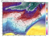
Wow. Have some td maps?Man, I just took a look at dewpoints, places like ATL , CAE, CLT, GSP, ATHENS, don't even get out of the 20's the whole duration.
Thanks for the info. What can help us with the mid levels more? Stronger HP obviously. We need those numbers to go negative.Eh +1 - +4 c or so for the event.
I was on there too. I recall all of that as well as you. I'm hoping as you do, we can get more sleet. This is really making me feel uneasy with more than one model honking now, within 7 days.I remember being on Shawn's SC weather forum during the 2014 storm and the continuous model runs showing icemageddon for us. Hopefully if this is going to come, things can trend better for us where we end up more sleet than freezing rain.
The Jan 1-2 storm is further North than GFS but good hit for N NC into Mid Atlantic. It's still 9-10 days out so sure it'll change, but general idea of tracking possible 2 threats at least over next week and half is there.


Sent from my SM-N950U using Tapatalk


Sent from my SM-N950U using Tapatalk
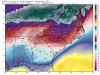
Sure, here are some maps for the duration:Wow. Have some td maps?
Attachments
olhausen
Member
Don’t forget us Tennessee folks. That run gives me hours and hours of ice followed by a number of hours of snow.Ya if I was in NC, I would be very excited. Big time storm
The Jan 1-2 storm is further North than GFS but good hit for N NC into Mid Atlantic. It's still 9-10 days out so sure it'll change, but general idea of tracking possible 2 threats at least over next week and half is there.
Sent from my SM-N950U using Tapatalk
Not happy with this stormThe Jan 1-2 storm is further North than GFS but good hit for N NC into Mid Atlantic. It's still 9-10 days out so sure it'll change, but general idea of tracking possible 2 threats at least over next week and half is there.
Sent from my SM-N950U using Tapatalk
Dang. That's really close hereSure, here are some maps for the duration:
NWMSGuy
Member
Man we’ve had a ton of Rain over here around Memphis. Still going at this hour.
Trust me, this is bold for MRX:
"Chances for precip for Wednesday and Wednesday night look
to be mainly across our southern counties, but for Thursday and
Friday better chances of precip spread across the area. There
should be some chances of wintry precip during this time, but it`s
low confidence on how significant this weather system will be in
the latter part of the week."
DT up late, putting out free stuff... he teaches us to count in the first part, lol:
We are supposed to be leaving next Friday to go to the beach, mainly for golf and looking at a condo to possibly purchase. I would really really REALLY be pissed off if I missed a good winter storm at home. If it looks like it could be a good pending storm I might just have a sit down with my wife and explain why we need to postpone.
6z Goof is further south with the 29th-30th storm.. robs southern New England and Mid Atlantic. heh... good for most of Tn and North Carolina.
packfan98
Moderator

packfan98
Moderator

Interesting, if you watch DT's latest video... he explains why a big snowstorm for MA and New England won't happen.. dude may be an ass, but his pattern recognition is second to none.
packfan98
Moderator
Miller A in the Gulf bringing winter precip to all of the Gulf states at hr 222...

D10 storm there and surpressed on 6z

Sent from my SM-N950U using Tapatalk


Sent from my SM-N950U using Tapatalk

accu35
Member

^ that's all kinds of wrong... ")
I think Gfs will adjust south with the 28th-30th system with stronger wedge!!
accu35
Member
Gfs is all over the place, who knows what will happen. Really.
JB has been talking about this for over 2 weeks. DT is always behind him. Been listening to both for years. Both are interesting to listen toInteresting, if you watch DT's latest video... he explains why a big snowstorm for MA and New England won't happen.. dude may be an ass, but his pattern recognition is second to none.
SimeonNC
Member
GEFS?
I'll be honest and let you know that CAD does not effect all the way down to ATL like it does the Carolinas and NE GA. With that said, the GFS temps are incorrect for all of us. Ignore the ptype maps, and that sounding. The Canadian makes more sense temperature wise.
It really depends on the strength of the CAD. I brought up about January 2005 last night. We started off in the mid 30s with sleet and spent most of that event in the mid to upper 20s. However, even a weak CAD definitely affects the immediate Atlanta metro area. It doesn't always guarantee wintry precipitation here, but the likelihood is very high. It doesn't even have to be the Winter season, I can't count the number of times CAD has saved Atlanta's butt a lot in severe weather outbreaks also.
EDIT: I think the HP in the January 2005 ice storm was only in the 1020s or 1030. If we have a 1030 or higher HP anchored to our NE, it'll most likely get the job done down here. Anyone know a good website to find archived surface analysis maps from that month/year. It was an end of the month storm, I think around 28th-29th. I know it started on a Friday afternoon and went through all of Saturday.
Last edited:
DadOfJax
Member
Cold rain for AL. Next!
That 10 day-ish system has been showing up fairly consistently on the GFS anyway! That looks like a classic 80s snowstorm for a good many people on the board!!
SimeonNC
Member
You got some with the last storm, let some of us in the east get our shot lolCold rain for AL. Next!
this page has some maps, if you can make sense out of them... http://www4.ncsu.edu/~nwsfo/storage/cases/20050119/It really depends on the strength of the CAD. I brought up about January 2005 last night. We started off in the mid 30s with sleet and spent most of that event in the mid to upper 20s. However, even a weak CAD definitely affects the immediate Atlanta metro area. It doesn't always guarantee wintry precipitation here, but the likelihood is very high. It doesn't even have to be the Winter season, I can't count the number of times CAD has saved Atlanta's butt a lot in severe weather outbreaks also.
EDIT: I think the HP in the January 2005 ice storm was only in the 1020s or 1030. If we have a 1030 or higher HP anchored to our NE, it'll most likely get the job done down here. Anyone know a good website to find archived surface analysis maps from that month/year. It was an end of the month storm, I think around 28th-29th. I know it started on a Friday afternoon and went through all of Saturday.
Happy New Year
Sent from my SM-G955U using Tapatalk

Sent from my SM-G955U using Tapatalk

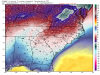
These are the kind of dew points you want to see right before an event

Sent from my SM-G955U using Tapatalk

Sent from my SM-G955U using Tapatalk
Storm5
Member
Yeah the eps has many amped warm waves which is why the mean went way down.
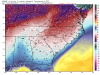
00z vs 12z yesterday


Sent from my iPhone using Tapatalk
00z vs 12z yesterday


Sent from my iPhone using Tapatalk
Storm5
Member
Gefs is all about the New Years storm
Sent from my iPhone using Tapatalk
Sent from my iPhone using Tapatalk