• Hello, please take a minute to check out our awesome content, contributed by the wonderful members of our community. We hope you'll add your own thoughts and opinions by making a free account!

Pattern December, Make analogs relevant again

Verbatim, I still don't think cold air will make it down fast enough for us to score. Honestly just looks like cold rain objectively

Do you know how to read the UKMET? If you don't it's best to just not give your opinion.

(Truthfully I don't think I can, myself, I'm not sure where the HP is on the map that I think is about pressures...if it's the basic 500 map I'm better)
 
Like I said, when you're talking about really long range, it's educated guesses. The educated guess of an early spring occurring due to La Nina is a really good one but still, it's an educated guess. Sometimes...Mother Nature will do what she will...
Exactly. That's what I'm trying to caution Eric about. Not saying that he couldn't be right, but Mother Nature will do what she desires. The super El nino that we all got excited about because we thought it would deliver cold and snow is a prime example. Look how that turned out. Outrageously warm and frustrating.
 
Do you know how to read the UKMET? If you don't it's best to just not give your opinion.

(Truthfully I don't think I can, myself, I'm not sure where the HP is on the map that I think is about pressures...if it's the basic 500 map I'm better)
I know what you're saying, no offense. I'm just basing it off the GFS a little because it had a similar 1040 high but verbatim not cold enough for snow or ice in places like Atlanta, Charolette, etc. And I just don't see the cold speeding up any quicker than that, especially given the horrible GFS cold bias.
 
Exactly. That's what I'm trying to caution Eric about. Not saying that he couldn't be right, but Mother Nature will do what she desires. The super El nino that we all got excited about because we thought it would deliver cold and snow is a prime example. Look how that turned out. Outrageously warm and frustrating.

Models didn't even come close to showing what it's shown over the past 30 days last Winter. Most have already scored. If the upcoming pattern doesn't excite you, you need to check your interest in weather. Meanwhile I'm over here with kids in my lap model watching, with excitement. Carry on...
 
Well, Eric no offense, but we don't know for certain if what you said in that post will even happen just because it has a tendency to do so. Weather is more complex than that in my opinion so for all we know that may not happen. Not being cold bias, in just saying.

Exactly. That's what I'm trying to caution Eric about. Not saying that he couldn't be right, but Mother Nature will do what she desires. The super El nino that we all got excited about because we thought it would deliver cold and snow is a prime example. Look how that turned out. Outrageously warm and frustrating.

These are loaded responses, yes it's obvious we don't know for certain but it's the best guess we can make at this juncture based on basic meteorological principles, observations, published literature, and NWP models, it's infinitely better than saying we shouldn't look this far out because we don't know and several others (such as Huffman & Masiello) are on board. I know you half heartedly admitting you're supposedly not being biased or anything, but it's pretty funny how when I make a long range diagnosis that points towards a potential warm pattern, it immediately gets questioned left & right and uncertainty is immediately stressed, but cold patterns are accepted at will and without much backlash on this forum. The public, weather enthusiasts, and meteorologists alike often confuse the scales and expectations on the predictability of a pattern with increasing range and get bent out of shape when specific solutions (like it doesn't snow in x location etc) differ wildly, but refuse to look at the overall, planetary scale picture which doesn't modify as quickly because it takes an appreciable amount of time for modeled errors to grow upscale and implicate the planetary-scale wave configuration. For example, planetary waves vary over the course of several weeks or more and evolve more slowly w/ time than the individual shortwaves that comprise them and they're quasi-stationary or slowly retrograde due to their vast scale that covers tens of thousands of square kilometers, they are in fact more predictable in this sense than synoptic scale shortwaves that comprise them and can be reasonably predicted a few weeks out or so

It's a Super El Nino superimposed onto background warming climate what do you expect lol. I made it very clear in my time on american and twitter that December would be a huge torch due to the canonical progression of NINO winters especially strong events and that the winter would progressively improve later on, which is pretty much what transpired, the December torch was made more ridiculous in part by the warming climate, put the same NINO event in the 18th or 19th centuries and the temperatures wouldn't have been nearly as warm.
 
Last edited:
Models didn't even come close to showing what it's shown over the past 30 days last Winter. Most have already scored. If the upcoming pattern doesn't excite you, you need to check your interest in weather. Meanwhile I'm over here with kids in my lap model watching, with excitement. Carry on...
I'm not saying the pattern isn't good but we've been down this road ER coaster before and it usually trends warmer or cold rain look. I'm excited if there is a prospect for winter storms, but right now the models are just so all over the place it's hard to be excited because it can turn out to be nothing.
 
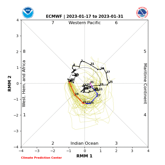
Hello, phase 8! As GaWx mentioned many times, the European guidance was vastly superior to the other guidance and has remained really consistent in predicting this evolution.

ECMF_phase_51m_full.gif

Who knows? This may actually be "The Driver of the Goods" when it's all said and done (at least for the next 2 or 3 weeks). Should be interesting to study some verification later on.
 
These are loaded responses, yes it's obvious we don't know for certain but it's the best guess we can make at this juncture based on basic meteorological principles, observations, published literature, and NWP models, it's infinitely better than saying we shouldn't look this far out because we don't know and several others (such as Huffman & Masiello are on board). I know you half heartedly admitting you're supposedly not being biased or anything, but it's pretty funny how when I make a long range diagnosis that points towards a potential warm pattern, it immediately gets questioned left & right and uncertainty is immediately stressed, but cold patterns are accepted at will and without much backlash on this forum. The public, weather enthusiasts, and meteorologists alike often confuse the scales and expectations on the predictability of a pattern with increasing range and get bent out of shape when specific solutions (like it doesn't snow in x location etc) differ wildly, but refuse to look at the overall, planetary scale picture which doesn't modify as quickly because it takes an appreciable amount of time for modeled errors to grow upscale and implicate the planetary-scale wave configuration. For example, planetary waves vary over the course of several weeks or more and evolve more slowly w/ time than the individual shortwaves that comprise them and they're quasi-stationary or slowly retrograde due to their vast scale that covers tens of thousands of square kilometers, they are in fact more predictable in this sense than synoptic scale shortwaves and can be reasonably predicted a few weeks out or so

It's a Super El Nino superimposed onto background warming climate what do you expect lol. I made it very clear in my time on american and twitter that December would be a huge torch due to the canonical progression of NINO winters especially strong events and that the winter would progressively improve later on, which is pretty much what transpired, the December torch was made more ridiculous in part by the warming climate, put the same NINO event in the 18th or 19th centuries and the temperatures wouldn't have been nearly as warm.

Your knowledge intimidates folks...
 
I think the best version of El Nino for Southeast purposes is a weak one. If memory is correct, that was what we saw 09/10...

2009-10 was arguably a low-end strong event/borderline weak-moderate El Nino, there were other factors (low solar activity, easterly QBO, strong +AMO, intrinsic mid-latitude variability) which allowed that winter to deliver more cold/snow. There was an appreciable mid-winter thaw that year following the mid December 2009 mid Atlantic crush job, and it ended w/ a major winter storm in NC on the 29th & 30th of January...
 
These are loaded responses, yes it's obvious we don't know for certain but it's the best guess we can make at this juncture based on basic meteorological principles, observations, published literature, and NWP models, it's infinitely better than saying we shouldn't look this far out because we don't know and several others (such as Huffman & Masiello are on board). I know you half heartedly admitting you're supposedly not being biased or anything, but it's pretty funny how when I make a long range diagnosis that points towards a potential warm pattern, it immediately gets questioned left & right and uncertainty is immediately stressed, but cold patterns are accepted at will and without much backlash on this forum. The public, weather enthusiasts, and meteorologists alike often confuse the scales and expectations on the predictability of a pattern with increasing range and get bent out of shape when specific solutions (like it doesn't snow in x location etc) differ wildly, but refuse to look at the overall, planetary scale picture which doesn't modify as quickly For example, planetary waves vary over the course of several weeks or more and evolve more slowly w/ time than the individual shortwaves that comprise them and they're quasi-stationary or slowly retrograde due to their vast scale that covers tens of thousands of square kilometers, they are in fact more predictable in this sense than synoptic scale shortwaves and can be reasonably predicted a few weeks out or so

It's a Super El Nino superimposed onto background warming climate what do you expect lol. I made it very clear in my time on american and twitter that December would be a huge torch due to the canonical progression of NINO winters especially strong events and that the winter would progressively improve later on, which is pretty much what transpired, the December torch was made more ridiculous in part by the warming climate, put the same NINO event in the 18th or 19th centuries and the temperatures wouldn't have been nearly as warm.
I'm just used to it being cold, and more snowy in El Nino winter's like 2010 was. Guess that was foolish of me to always expect that. I'm not trying to cause offense or question your creditability Eric. I know better now because of GFS cold bias but based on these models now I'm doubtful we may even score at all and you'll may be right and we'll go back to being warm and boring. Who wants that? That's why we may question it a little even though it's probably right it sucks. Your right, that was most likely a half-hearted response and I deeply apologize. It would be a hard pill to swallow if we went on this whole wild goose winter storm chase for nothing and you, Allan Huffman, and Masiello, turn out to be right and we go to warm.
 
Hello, phase 8! As GaWx mentioned many times, the European guidance was vastly superior to the other guidance and has remained really consistent in predicting this evolution.

ECMF_phase_51m_full.gif

Definitely losing the MJO signal in the western hemisphere here, certainly behaving more like a moist, fast moving Kelvin Wave (than usual) in this part of the globe.
 
Like I said, when you're talking about really long range, it's educated guesses. The educated guess of an early spring occurring due to La Nina is a really good one but still, it's an educated guess. Sometimes...Mother Nature will do what she will...

Their is no more truth in that statement well said:)
 
Did you even read my post or that paper at all? Apparently not.
Well. I did read your post. Much of what I have replied to today was not things that you have said, but were from comments made by other folks. But, since you asked...Much of your posts say in many, many words what often happens or what is likely to happen if this and this and then this. These are all good points. I truly do admire the amount of research you have done and the knowledge that you obviously have; however, the weather does not always do what it should do or often does, or is likely to do if A, B and C happen. If that were the case, we would know. As the sometimes beloved and often maligned JB will say "only God knows what is going to happen". The most we can do is try to use the information we have to make the most informed forecasts or in the case of most of us, guess. The further out we go the lower the skill. I have no doubt your skill out weighs most on this board, so no intent to offend by my comments.
 
you are right, the cold is farther north on the 25th, but the HP over so. canada is stronger, and the LP over the Tex and OKL panhandle is stronger kicking the 850s north quicker.LP is Digging more?
 
I'm just used to it being cold, and more snowy in El Nino winter's like 2010 was. Guess that was foolish of me to always expect that. I'm not trying to cause offense or question your creditability Eric. I know better now because of GFS cold bias but based on these models now I'm doubtful we may even score at all and you'll may be right and we'll go back to being warm and boring. Who wants that? That's why we may question it a little even though it's probably right it sucks. Your right, that was most likely a half-hearted response and I deeply apologize. It would be a hard pill to swallow if we went on this whole wild goose winter storm chase for nothing and you, Allan Huffman, and Masiello, turn out to be right and we go to warm.

Sure no problem I understand I too would like to see a good snowstorm this year, I totally understand the pain as I've been deprived of snow many times over in RDU the past several years, the dreaded warm nose has kicked our butt time & time again... I just try to stay the course and objectively report what I see, surely we could stay colder longer for example if this arctic airmass takes its sweet time to leave but the probabilities are higher we turn milder later on in the month. Yes mother nature will do what she wants from time-to-time and I respect that but there's a lot more room for error when forecasting the behavior of planetary-scale waves vs shortwaves and individual areas of low & high pressure that compose them because they're so large
 
Your knowledge intimidates folks...
With all due respect and not to be the least bit argumentative ... Webb's knowledge is not intimidating (sure, you may need Google open sometimes to get the full drift, and maybe he could do a more down home pedestrian summary once in a while, but that's his call); rather his knowledge is informative, and I know with 100% certainty (based on PMs) that he really cares about educating us folks. In fact, if you don't fully understand Webb's posts, he's generally very amenable to helping you out -- if you ask and don't challenge. I can't say that I always agree with Webb, but I'm the first to admit that in a 100 point game he's outscored me 98 to 2 -- since the old American days.
So how's about chilling and just maybe learning a thing or two from Webb?
We're fortunate to have him as part of the team.
No - strike that -
We're very fortunate ...
Rant over ...
;)
 
I12z euro has a light band of wintry right along the front next Wednesday . Extremely light
dab347e1f26da29959ea352f2c45a1a2.jpg


Sent from my iPhone using Tapatalk
 
Based on GaWx's, my own, and other's research into less than 1 amplitude MJO impulses and impacts on SE temps and snowfall, that may be just what we're after for this upcoming period.

I would be very intrigued to see a similar analysis w/ the VPM or OMI MJO indices, the RMM MJO index is quite noisy and due to its utilization of OLR, it often underestimates MJO events in the Western Hemisphere esp relative to the VPM index. If after such an analysis we still find that weaker MJO events are favored over large amplitude ones in generating more cold in the southeastern US then this begs the question which higher frequency convectively coupled equatorial waves that compose the MJO, are most important in generating this weak, yet still discernible signal we see on the RMM index? Convectively Coupled Equatorial Kelvin Waves would be the first place to look as they provide the biggest contribution of all CC Eq waves to the MJO's cloudiness and convection which generates the extratropical circulation changes.
 
Climo likes this time frame. I've seen a few New Years frozen fun times. I will give this potential high marks. Higher than I would have given the recent event, ahead of time.
I agree I have seen more winter storms this time of year ( l go back to the 60,s ) than any other time of winter:D
 
I know El nino /La nina is just a portion of the forecast puzzle, but I know from what I'm reading most are banking on La nina. We are presently considered to be in a very weak La nina . Also, most of the water north of the Equator is slightly warmer than normal ( especially close to Central America. Judging from the trends over the last few weeks I don't see that area making it to Nina temps , and we may not sustain La nina into January.Therefore I think much of the long range forecast may be off a bit because of the weight put on el nino / lLa nina .
 
Back
Top