-
Hello, please take a minute to check out our awesome content, contributed by the wonderful members of our community. We hope you'll add your own thoughts and opinions by making a free account!
You are using an out of date browser. It may not display this or other websites correctly.
You should upgrade or use an alternative browser.
You should upgrade or use an alternative browser.
Pattern December Dud 👀
- Thread starter SD
- Start date
View attachment IMG_0455.jpeg
Foggy morning on the coast.
Foggy morning on the coast.
Unpinning this turd. Good riddance
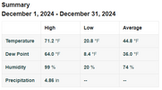
Been a Good December Here in mby. Will end up Below Normal ( by the skin of our teeth .5) and had an accumulating all snow event, even though it was less than 1 inch. Highlight was a nice 7 dayish stretch of sustained well below normal cold outbreak to start the month off.
January has the chance to give this winter an A Grade with its first 15 days. Regardless of what the 2cnd half of winter/ Feb does.
Really shocked I can write this annalysis, compared to what we all thought pre- season , as late as early to mid November. But here we are.
January has the chance to give this winter an A Grade with its first 15 days. Regardless of what the 2cnd half of winter/ Feb does.
Really shocked I can write this annalysis, compared to what we all thought pre- season , as late as early to mid November. But here we are.
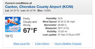
We are going to hit 70 today.
gawxnative
Member
Would not be shocked with the virtually clear skies... Is 68 here currently (Out near to Monroe, in Walton CountyWe are going to hit 70 today.
RIP
Isn't the wives tale you have to get a tornado to get the snow
You gotta smell the debris to get the snowIsn't the wives tale you have to get a tornado to get the snow
My brother just sent me a video from Lake Acworth with white capped waves. Looked like the gulf in a storm.Man it’s windy around Atlanta
View attachment 158164
- Joined
- Jan 5, 2017
- Messages
- 3,769
- Reaction score
- 5,966
Made it to 70! It's very windy. I keep losing power.
I topped out at 68 and have dropped to 61. Pretty constant high teens for winds even at my sheltered station.Made it to 70! It's very windy. I keep losing power.
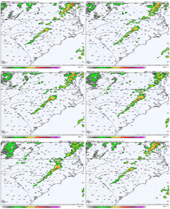
That line of storms is cooking across VA
- Joined
- Jan 5, 2017
- Messages
- 3,769
- Reaction score
- 5,966
Even though it's 69 now, the dewpoint is 40 with a relative humidity of 35%. It's not that warm when the wind blows with those low dews.
Max: 73.4
Min: 18.7
Avg: 43.7
Rain: 7.09
Snow: 0.00
Min: 18.7
Avg: 43.7
Rain: 7.09
Snow: 0.00
Line of storms in the triad is impressive
- Joined
- Jan 23, 2021
- Messages
- 4,595
- Reaction score
- 15,183
- Location
- Lebanon Township, Durham County NC
ETA 12 minutes hereLine of storms in the triad is impressive
Might be the first ground covering of frozen this winterETA 12 minutes here
- Joined
- Jan 23, 2021
- Messages
- 4,595
- Reaction score
- 15,183
- Location
- Lebanon Township, Durham County NC
Decent hail signature on that line
packfan98
Moderator
Hail here.
HRRR ftw, line of storms intense
- Joined
- Jan 23, 2021
- Messages
- 4,595
- Reaction score
- 15,183
- Location
- Lebanon Township, Durham County NC
Your bonus is a cold rain.
Didn't expect a good thunderstorm tonight.
Brent
Member
Apparently there's severe weather at the ball drop in Times Square
Snow in 6 days when hail is involved
 Fortunate enough to see snow the last 3 times to the NC mountains. Feel like I’m cheating because it’s been to Sugar and Beech(twice). Snow is coming down hard now but we’ve experienced graupel, snow and hail today including a lightning strike which cleared us off the slopes. Happy New Year and let’s bring it to the Triangle!!
Iceagewhereartthou
Member
Finishing the year with 77.74 inches of rain!
I’m at 62.11 from mid march on since my station died before then. It was feast or famine though.Finishing the year with 77.74 inches of rain!
CumulonimbusIncus
Member


