-
Hello, please take a minute to check out our awesome content, contributed by the wonderful members of our community. We hope you'll add your own thoughts and opinions by making a free account!
You are using an out of date browser. It may not display this or other websites correctly.
You should upgrade or use an alternative browser.
You should upgrade or use an alternative browser.
Pattern December Doldrums 2025 🎄 ❄️
- Thread starter SD
- Start date
I don't think KRDU will break any high temperature records over the holidays but it will be plenty warm. For KRDU the high temperature records for December 24, 25 and 26 are
December 24 77
December 25 75
December 26 75
December 24 77
December 25 75
December 26 75
Drizzle Snizzle
Member
High of 73 today !
Drizzle Snizzle
Member
I think it might be time to find some Live Cams in the Lake Tahoe area.WINTER STORM WARNING REMAINS IN EFFECT FROM 10 PM TUESDAY TO 10 AM PST FRIDAY
* WHAT...Heavy snow. Snow accumulations between 1 to 2 feet for Lake
Tahoe communities with 3 to 5 feet above 7,000 feet. Winds gusting
as high as 100 mph along the highest ridges and up to 50 mph in
the lower elevations and on Lake Tahoe.
* WHERE...Greater Lake Tahoe Area.
* WHEN...From 10 PM Tuesday to 10 AM PST Friday.
* IMPACTS...Travel and outdoor recreation could be very difficult to
impossible. The hazardous conditions could impact commutes
Wednesday and Christmas Day. Very strong winds could cause
extensive damage to trees and power lines.
NCHighCountryWX
Member
- Joined
- Dec 28, 2016
- Messages
- 699
- Reaction score
- 1,918
52” on the ground at the Togowotee Pass Snotel in Wyoming
NCHighCountryWX
Member
- Joined
- Dec 28, 2016
- Messages
- 699
- Reaction score
- 1,918
Brent
Member
Already 3 degrees off the all time December high here haha
Still 4 more days to go
Still 4 more days to go
LukeBarrette
im north of 90% of people on here so yeah
Meteorology Student
Member
2024 Supporter
2017-2023 Supporter
The warmest 54 degrees ever outside rn
Stormlover
Member
some good ones when it's snowing https://theshopsatheavenly.com/webcams/I think it might be time to find some Live Cams in the Lake Tahoe area.
BrickTamland
Member
We gotta get warm so the pendulum can swing back to the other extreme to even things out.
Literally the only warmth we've seen since Thanksgiving lasts less than a week and then goes right back to this lol. January will not disappoint.
Sunday Night
A chance of rain and snow. Mostly cloudy, with a low around 28. Chance of precipitation is 40%.
Monday
A 10 percent chance of snow. Mostly sunny, with a high near 37.
Monday Night
Mostly clear, with a low around 18.
Tuesday
Sunny, with a high near 37.
Sunday Night
A chance of rain and snow. Mostly cloudy, with a low around 28. Chance of precipitation is 40%.
Monday
A 10 percent chance of snow. Mostly sunny, with a high near 37.
Monday Night
Mostly clear, with a low around 18.
Tuesday
Sunny, with a high near 37.
The fact that we’ve had this much phase 8 and no real reward in the upper south is criminal and I’ll never not be mad about it
I still feel that the phase 8 periods of this month are getting too negative of an assessment when considering
history. I feel that the issue is too high expectations.
For your area (I used Elizabethton, TN when available and Bristol when not) as representative of the SE, please keep these facts about Dec phase 8 days in mind:
-the MJO phase 8 days within the 19 Decs with only 1- 4 phase 8 days actually averaged mild (5 AN) and only 4 of those 19 had snow (only 2020 had measurable (3.6”))
-the MJO days within the 10 Decs with 5+ phase 8 days (like 2025) averaged (excluding 2025) much colder (4 BN) with an avg coldest of 17 and coldest coldest of 0 (1989); snow for these 10 Dec phase 8s was 5 with none, 3 with a T, one with 0.2”, and one with 4” (1989)
-2025’s phase 8 days so far have averaged 5 BN, which is actually slightly colder than the avg for 5+ day Decs of 4 BN
-2025’s coldest during phase 8 days has been way down at 6; only 1989 had a colder coldest during phase 8 for the 29 Decs with a phase 8
-2025’s phase 8 days so far have had a T of snow; only 2 of the 10 (20%) prior Decs with 5+ days of phase 8 had measurable snow (1989 had 4” and 1992 had 0.2”); the T is already enough to beat the 0” of half of these 10
Summary:
The phase 8 days this month have averaged about as cold as the avg phase 8 day temperatures for Decs with 5+ of them, this month’s coldest during phase 8 of 6F beat all of the other 29 Dec phase 8 periods’ coldest except only 1989’s 0F, and the T of snow this month was beaten by only 3 of the 29 Dec phase 8 periods (1989’s 4”, 2020’s 3.6”, and 1992’s 0.2”).
That’s why I feel this month’s phase 8 did well vs history. I’ll give a full assessment of this month’s phase 8 days once the month is complete as there could still be more.
Last edited:
trackersacker
Member
It might have done what it was supposed to in terms of temperatures. It just pisses me off when we have to get into certain phases of the MJO to get snowfall to work at all and then we get ripped off. Like obviously I’m not getting anything in phase 4 during a La Niña but phase 8 was supposed to give us more of a shot than not.I still feel that the phase 8 periods of this month are getting too negative of an assessment when considering
history. I feel that the issue is too high expectations.
For your area (I used Elizabethton, TN when available and Bristol when not) as representative of the SE, please keep these facts about Dec phase 8 days in mind:
-the MJO phase 8 days within the 19 Decs with only 1- 4 phase 8 days actually averaged mild (5 AN) and only 4 of those 19 had snow (only 2020 had measurable (3.6”))
-the MJO days within the 10 Decs with 5+ phase 8 days (like 2025) averaged (excluding 2025) much colder (4 BN) with an avg coldest of 17 and coldest coldest of 0 (1989); snow for these 10 Dec phase 8s was 5 with none, 3 with a T, one with 0.2”, and one with 4” (1989)
-2025’s phase 8 days so far have averaged 5 BN, which is actually slightly colder than the avg for 5+ day Decs of 4 BN
-2025’s coldest during phase 8 days has been way down at 6; only 1989 had a colder coldest during phase 8 for the 29 Decs with a phase 8
-2025’s phase 8 days so far have had a T of snow; only 2 of the 10 (20%) prior Decs with 5+ days of phase 8 had measurable snow (1989 had 4” and 1992 had 0.2”); the T is already enough to beat the 0” of half of these 10
Summary:
The phase 8 days this month have averaged about as cold as the avg phase 8 day temperatures for Decs with 5+ of them, this month’s coldest during phase 8 of 6F beat all of the other 29 Dec phase 8 periods’ coldest except only 1989’s 0F, and the T of snow this month was beaten by only 3 of the 29 Dec phase 8 periods (1989’s 4”, 2020’s 3.6”, and 1992’s 0.2”).
That’s why I feel this month’s phase 8 did well vs history. I’ll give a full assessment of this month’s phase 8 days once the month is complete as there could still be more.
Thank you for your research and insight though. That’s a lot of homework.
Brent
Member
It might have done what it was supposed to in terms of temperatures. It just pisses me off when we have to get into certain phases of the MJO to get snowfall to work at all and then we get ripped off. Like obviously I’m not getting anything in phase 4 during a La Niña but phase 8 was supposed to give us more of a shot than not.
Thank you for your research and insight though. That’s a lot of homework.
I get it but unfortunately living in the south there's never any guarantees. Too much cold it's dry etc. it's such a fine line
Trust me I've been there haha especially moving to a somewhat better climate. I assumed a lot of things here that have been proven wrong already
Look at how much the US population weighted HDD rose on the EPS mean from the 12/17 12Z run to the 12/22 0Z run for 12/28-31: 25 HDD (from a way BN 74 to a NN 99)! Normal is 100 HDD.
12/17 12Z HDD run in purple on left
View attachment 179550
12/22 0Z HDD run in purple on left
View attachment 179551
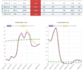
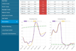
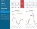
Followup: As the quoted post showed, US pop weighted HDD rose sharply on the EPS from the 12/17 12Z run’s well BN 74 to the 12/22 (Mon) 0Z run’s NN 99 for 12/28-31, meaning a much colder change.
What has happened on the EPS since that Mon run?
- 12/28-31 has maintained 24 of that 25 HDD gain from 12/17 with it at 98 HDD
- 1/1-4 has gone from a well BN 78 HDD on the 12/22 0Z run to a NN 101 on the 12/24 0Z run. And that’s even with the 12/24 0Z run not being as cold as the 12/23 12Z run’s 108 HDD!
-So, just since a week ago, the EPS’ US pop weighted HDD have increased a whopping ~47 HDD just for the period 12/28-1/4 (from way BN to NN)! That is a US avg of 6F colder per day, which probably means something like 8F colder/day in just the E US, alone, since the W is probably a little warmer.
12/24 0Z HDD run left side in purple:
12/22 0Z HDD run left side in purple
12/17 12Z HDD run left side in purple: look at how warm that run was compared to today’s! All days had BN to well BN HDDs:
Last edited:
68/52 at 10:55am #tothemoon
Month to date we're "up" to -6.2F below average at KFLO, which is somewhat of a warm station. Looks like we may get 4 days or so of AN weather with the wedge mixed in on Friday being a wash. BN for 3 days to close out December should keep us fairly below average for the month as a whole.
- Joined
- Jan 5, 2017
- Messages
- 3,770
- Reaction score
- 5,969
Here we go! Currently 68.2 with a dewpoint if 59.9. It's basically June at this point. Temp rise looks like the Cyclone at Six Flags. Will we touch 75?
- Joined
- Jan 5, 2017
- Messages
- 3,770
- Reaction score
- 5,969
I'm about to offset that with some CDD.Followup: As the quoted post showed, US pop weighted HDD rose sharply on the EPS from the 12/17 12Z run’s well BN 74 to the 12/22 (Mon) 0Z run’s NN 99 for 12/28-31, meaning a much colder change.
What has happened on the EPS since that Mon run?
- 12/28-31 has maintained 24 of that 25 HDD gain from 12/17 with it at 98 HDD
- 1/1-4 has gone from a well BN 78 HDD on the 12/22 0Z run to a NN 101 on the 12/24 0Z run. And that’s even with the 12/24 0Z run not being as cold as the 12/23 12Z run’s 108 HDD!
-So, just since a week ago, the EPS’ US pop weighted HDD have increased a whopping ~47 HDD just for the period 12/28-1/4 (from way BN to NN)! That is a US avg of 6F colder per day, which probably means something like 8F colder/day in just the E US, alone, since the W is probably a little warmer.
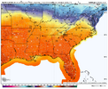
12/24 0Z HDD run left side in purple:
View attachment 179790
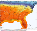
12/22 0Z HDD run left side in purple
View attachment 179791
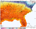
12/17 12Z HDD run left side in purple: look at how warm that run was compared to today’s! All days had BN to well BN HDDs:
View attachment 179792
Drizzle Snizzle
Member
it’s 77 here at 1:12pm. We’re gonna make a run for 80.
Nice well timed holiday warm shot wedged in an overall cool/cold winter so far. Gonna feel great shooting ball on my son’s new bball goal tomorrow afternoon. I ordered the chain net and everything.it’s 77 here at 1:12pm. We’re gonna make a run for 80.
- Joined
- Jan 5, 2017
- Messages
- 3,770
- Reaction score
- 5,969
73.4/59.6, relative humidity of 63%. Still have cool air trapped in the house, but likely going to run the A/C tomorrow.
AJ1013
Member
77/59 here. Similar weather to most of you haha
2nd warmest Christmas Eve ever for CHA, was 73 earlier, currently 71.
- Joined
- Jan 2, 2017
- Messages
- 1,566
- Reaction score
- 4,279
Topping out at 75 here..got a lil tan golfing!
Iceagewhereartthou
Member
Wow pretty amazing stuff. My forecast for Sat now up to 77! Even the cool down for next week has moderated; was looking at 41/20, now showing 47/25.
Not warm. It’s legit hot
Shorts on riding the golf cart
Shorts on riding the golf cart
Drizzle Snizzle
Member
Never in my life have I seen it this warm on Christmas Eve. Currently 78.
Wow. Atlanta made it up to 79 at the airport
Wow. Atlanta made it up to 79 at the airport
Impressive! That ties today with 12/1/1991 for the warmest on record anytime in Dec! Records go back to 1878!
75.6 and my wife told me I looked like a grumpy snowman. I hate sweating in winter.
So KATL was 75 at 2:50, made it to 79 in just ten minutes at 2:00 pm. At 2:10 it was 75 again. It’s a miracle!Wow. Atlanta made it up to 79 at the airport
Fulton county, just a few miles away, made it to just 75. It is what it is at this point. My blame lies with FFC, they either want it this way or just don’t care.
I have 72.7 at home.
I agree it’s pretty much BS. Looks like officially will go down as 78So KATL was 75 at 2:50, made it to 79 in just ten minutes at 2:00 pm. At 2:10 it was 75 again. It’s a miracle!
Fulton county, just a few miles away, made it to just 75. It is what it is at this point. My blame lies with FFC, they either want it this way or just don’t care.
I have 72.7 at home.
- Joined
- Jan 5, 2017
- Messages
- 3,770
- Reaction score
- 5,969
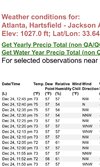
My high in the front yard was 73.6, about 15 miles south of Hartsfield. KFFC doesn't care to move the sensor. It does report the UHI effect well, though. Downtown Atlanta is this way as well. General suburban areas will typically report 3 to 4 degrees cooler even just a few miles away. 72.3 now.So KATL was 75 at 2:50, made it to 79 in just ten minutes at 2:00 pm. At 2:10 it was 75 again. It’s a miracle!
Fulton county, just a few miles away, made it to just 75. It is what it is at this point. My blame lies with FFC, they either want it this way or just don’t care.
I have 72.7 at home.
Their station didn’t have this issue over ten years ago, it’s either been moved or changed. I can tell you exactly what it is. When the sun is at a certain angle in the afternoon, it shines between the ribbed covers that are supposed to prevent direct sunlight, but it can cause anomalies exactly like we are seeing. It doesn’t happen on overcast days.My high in the front yard was 73.6, about 15 miles south of Hartsfield. KFFC doesn't care to move the sensor. It does report the UHI effect well, though. Downtown Atlanta is this way as well. General suburban areas will typically report 3 to 4 degrees cooler even just a few miles away. 72.3 now.
Last edited:
I agree it’s pretty much BS. Looks like officially will go down as 78
Well, if a record is going to be broken, you might as well smash it. Five degrees over the previous high temperature qualifies as a smash job.
Anything in the seventies on Christmas Eve is an abomination to me. Perhaps that temperature recording station needs to be checked for accuracy. Raleigh was also recording some dubious high temperatures for a while, but I think that problem has been solved for now.

