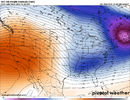
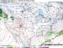
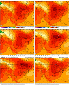
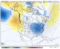
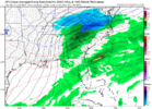
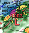
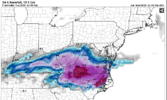
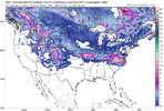
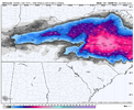
On the bright side it will probably take another 50 years to have one this favorable again.Can’t believe we are actually doing the thing with the MJO..
Now we sit back & wait.
-
Hello, please take a minute to check out our awesome content, contributed by the wonderful members of our community. We hope you'll add your own thoughts and opinions by making a free account!
You are using an out of date browser. It may not display this or other websites correctly.
You should upgrade or use an alternative browser.
You should upgrade or use an alternative browser.
Pattern December Doldrums 2025 🎄 ❄️
- Thread starter SD
- Start date
Bigedd09
Member
GFS for one time in your miserable life please be right!!

Sent from my iPhone using Tapatalk

Sent from my iPhone using Tapatalk
BrickTamland
Member
GFS has been on a roll with showing winter storms here around 6 or 7 days out. Maybe if it does it enough it will finally get one right.GFS for one time in your miserable life please be right!!
Sent from my iPhone using Tapatalk
Bigedd09
Member
GFS has been on a roll with showing winter storms here around 6 or 7 days out. Maybe if it does it enough it will finally get one right.
I have very low confidence in tho model but fun to look at. Who knows!
Sent from my iPhone using Tapatalk
- Joined
- Jan 2, 2017
- Messages
- 1,566
- Reaction score
- 4,279
I highly doubt it reaches nw sc as my weather is pretty much Toccoas weather. Give me a true cad and a gulf lowI can already tell how this system on the 6th will go.. Probably going to manage to somehow get snow all the way in the upstate, then sit right at the GA SC Border skipping out NE GA.
(Sorta a joke but kinda true with how things go around here.)
packfan98
Moderator
FWIW, the 18z GEFS looks to have improved on both our periods of interest.
Early next week at-least has UL support (compared to the Friday system) with pretty much all guidance indicating a sharpening s/w ivo the SE with HP building in to New England.
What is your idea of a true CAD?I highly doubt it reaches nw sc as my weather is pretty much Toccoas weather. Give me a true cad and a gulf low
What is your idea of a true CAD?
Y'all are in just about the worst place to get snow that otherwise "should" get snow. Something about being on the lee side of the mountains in far NE Georgia and far NW South Carolina just doesn't lend itself to snow. Ice certainly with CAD, but lacking in snow.
iwantsouthernsnow123
Member
In this situation, it may be able to. the GSP region doesn't look terrible overall, very close call. Could see the mix line possibly somewhere in there. However as far as toccoa goes, It looks like it's going to be just out of reach of decent 700-925mb. Could trend up? Maybe, Likely? NoI highly doubt it reaches nw sc as my weather is pretty much Toccoas weather. Give me a true cad and a gulf low
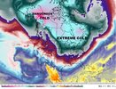
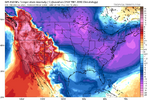
I see Extreme and Dangerous cold but where's the Ludicrous cold?It’s happening…View attachment 177761
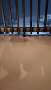
This is at my condo up on Beech right now. Nice surprise to end the day.drizzle has turned to snizzle with mood flakes flying in the high country this evening
and how about banner elk defying the odds. looks like it could be more than a dusting at this point there.
View attachment 177756
Attachments
Actually it's been the opposite lately. We haven't had a big ice storm here in a very long time. Matter of fact we don't get any winter weather at all anymore it seems. GSP always since records pretty much began got a double digit snowfall year about once every five years. Now its been 32 years since one so it seems it may not happen again in my lifetime. It actually used to snow here. At one point the all time yearly average was 7.7 inches. Not even sure what that is anymore, but the 30 year average is 4.7 inches now. Still higer than CLT. And thats going to tumble after this decade. The 90s which is the least snowiest decade had 39 inches or 3.9 average. This decade so far? I've had about 9 inches and the decade is half over. And 6.5 of that was one storm. So on track to finish less than 20 inches or half as much as the 90s. Absolutely pathetic and almost no words for it. Trust me, all the whining and crying from the upstate crowd is warranted.Y'all are in just about the worst place to get snow that otherwise "should" get snow. Something about being on the lee side of the mountains in far NE Georgia and far NW South Carolina just doesn't lend itself to snow. Ice certainly with CAD, but lacking in snow.
J1C1111
Member
My man! I couldn't of said it any better!Actually it's been the opposite lately. We haven't had a big ice storm here in a very long time. Matter of fact we don't get any winter weather at all anymore it seems. GSP always since records pretty much began got a double digit snowfall year about once every five years. Now its been 32 years since one so it seems it may not happen again in my lifetime. It actually used to snow here. At one point the all time yearly average was 7.7 inches. Not even sure what that is anymore, but the 30 year average is 4.7 inches now. Still higer than CLT. And thats going to tumble after this decade. The 90s which is the least snowiest decade had 39 inches or 3.9 average. This decade so far? I've had about 9 inches and the decade is half over. And 6.5 of that was one storm. So on track to finish less than 20 inches or half as much as the 90s. Absolutely pathetic and almost no words for it. Trust me, all the whining and crying from the upstate crowd is warranted.
J1C1111
Member
December 17 repeat with moisture on top would be what the doctor ordered!
CNCsnwfan1210
Member
Need to shove that ridge SE toward Alaska, but overall that’s a good adjustment from previous.
Sent from my iPhone using Tapatalk
MRKEVIN7575
Member
I guess the pacific jet is retracting soon. Is it the +EAMT causing it? Hopefully soon it will allow a -epo to build over Alaska.
CNCsnwfan1210
Member
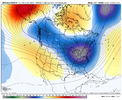
Here’s the cold air associated with the 1065mb high at the end happy hour GFSView attachment 177771
That’s the kind of HP you want to see with a phase 8/stratwarm/ polar vortex lobe dropping south, we’ve seen this stuff before. I know it’s an OP run, but it just shows what kind of an airmass you can get with those factors I mentioned come into play.
Sent from my iPhone using Tapatalk
MRKEVIN7575
Member
The euro and gfs has been showing really cold air at times in runs.That’s the kind of HP you want to see with a phase 8/stratwarm/ polar vortex lobe dropping south, we’ve seen this stuff before. I know it’s an OP run, but it just shows what kind of an airmass you can get with those factors I mentioned come into play.
Sent from my iPhone using Tapatalk
- Joined
- Jan 2, 2017
- Messages
- 1,566
- Reaction score
- 4,279
Roughly a 1040 high parked in northeast Virginia as a low pressure tracks through Atlanta. Coupled with a solid block to hold it in place!What is your idea of a true CAD?
- Joined
- Jan 2, 2017
- Messages
- 1,566
- Reaction score
- 4,279
Well said my man! I guess we are to the point that at least we got to see and enjoy the snowy late 70's through the late 80's. Had some awesome snow "weeks" out of school back then.Actually it's been the opposite lately. We haven't had a big ice storm here in a very long time. Matter of fact we don't get any winter weather at all anymore it seems. GSP always since records pretty much began got a double digit snowfall year about once every five years. Now its been 32 years since one so it seems it may not happen again in my lifetime. It actually used to snow here. At one point the all time yearly average was 7.7 inches. Not even sure what that is anymore, but the 30 year average is 4.7 inches now. Still higer than CLT. And thats going to tumble after this decade. The 90s which is the least snowiest decade had 39 inches or 3.9 average. This decade so far? I've had about 9 inches and the decade is half over. And 6.5 of that was one storm. So on track to finish less than 20 inches or half as much as the 90s. Absolutely pathetic and almost no words for it. Trust me, all the whining and crying from the upstate crowd is warranted.
1.34 today, .1 less than entire month of Nov
SnowNiner
Member
That’s what I’m talking about. Replace that west Canadian trough with a tall ridge and we’d be in business. Cold would get better south and shortwaves would dig. Let it begin indeed.
18z gfs shows how fluid and touchy the west coast gets towards mid month. Typical la nina game we are playing here, wouldn't be surprised to see some massive arctic shots on the models post D10 along with the next run being near record highs. I want to see if this period of western trough and eastern ridge may be enough to try to at least attempt to kick off a -nao
tonysc
Member
I live in Greenwood and I can associate a good snow storm with every year I was in school from about the 4th grade through the 12th grade, and an ice storm thrown in there some years too. But then, that was during the great winters of the 60's and 70's. It was just easier for it to snow around here back then.Well said my man! I guess we are to the point that at least we got to see and enjoy the snowy late 70's through the late 80's. Had some awesome snow "weeks" out of school back then.
LukeBarrette
im north of 90% of people on here so yeah
Meteorology Student
Member
2024 Supporter
2017-2023 Supporter
if central NC gets a blockbuster event on the anniversary of the last REALLY good snowstorm we had (Dec 8-9 2018), that'd be all kinds of marvelous
It would seem quite possible considering the indices:
- rising -NAO
- rising -AO
- weak MJO phase 8 (near or inside circle)
- quick +PNA spike
Iceagewhereartthou
Member
It excludes SC so at least that part is spot onGFS for one time in your miserable life please be right!!
Sent from my iPhone using Tapatalk
NBAcentel
Member
Man only if the western ridge was taller. Not gonna be easy with how the flow is, -NAO is trying to slow things down but the trough over AK trough Canada is pancaking the western ridge, and making the flow faster, not a huge believer in this one tbh, but I could be wrong and I hope I am, the surface pattern is mint honestly with the trailing high following the low in SE Canada but if there’s issues it’s the wave itself 