Blue_Ridge_Escarpment
Member
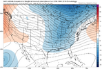
Beat me to it!Exactly what you want to see. Smoosh that TPV lobe further south and drag its cold nuts over the SE to allow more cold penetration and then a oozing of cold air east of the apps prior to the day 7 system View attachment 177525
A terrible CAD model is going for the CAD3 run run trend of the ICOn modeL View attachment 177527
I don’t understand how this thing could cut So far northward…3 run run trend of the ICOn modeL View attachment 177527
If the players keep playing the way they are, it won’t.I don’t understand how this thing could cut So far northward…
Almost the same footprint as the Tuesday system
CAD just don’t CAD like it used to for my area. Looks solid for NC though.
The perfectly horizontal cutoff line is amazing.


CFS AO forecast
Sent from my iPhone using Tapatalk


Meh. GEFS ensembles are just more goofuses. And, I'm being fair by not going beyond an ensembles useful range of 10 days.The GEFS with zero response to MJO progression. Instead just nukes the entire Southern section of the lower 48 with a broad ridge into mid month.


Yeah the gfs and it's ensembles haven't performed well at all. As most have noted we were supposed to be in an endless torch with no light at the end of the tunnel.Meh. GEFS ensembles are just more goofuses. And, I'm being fair by not going beyond an ensembles useful range of 10 days.
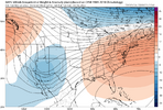
How it's going, top image: How it started, bottom image:View attachment 177547View attachment 177546
The GEFS with zero response to MJO progression. Instead just nukes the entire Southern section of the lower 48 with a broad ridge into mid month.
This has been the theme now for several months.Meh. GEFS ensembles are just more goofuses. And, I'm being fair by not going beyond an ensembles useful range of 10 days.
How it's going, top image: How it started, bottom image:View attachment 177547View attachment 177546
In fairness the EPS has really struggled as well until we get into the medium range. If you remember 2 weeks ago, the EPS was showing full on torch for the coming weekYeah the gfs and its ensembles haven't performed well at all. As most have noted we were supposed to be in an endless torch with no light at the end of the tunnel.
ICON looked icy, too. Time to start the first storm thread of the year for the N. Carolina and Virginia crew, don't y'all think?12z GFS at hour 126:
View attachment 177555
