I mean, where’s all the discussion? Should be a lot of severe today, especially for NC peeps!?
-
Hello, please take a minute to check out our awesome content, contributed by the wonderful members of our community. We hope you'll add your own thoughts and opinions by making a free account!
You are using an out of date browser. It may not display this or other websites correctly.
You should upgrade or use an alternative browser.
You should upgrade or use an alternative browser.
Pattern August Rush
- Thread starter accu35
- Start date
pcbjr
Member
If I may momentarily jump back in (since I posted the maps) ... Usually I mention that they are merely probability maps, and not reflective of actual temps; but that was not the point of the post, as ForsythSnow so astutely realized ... the point was that the "hype" (not from here, btw) that summer "is over" is just not necessarily based in reality ... ergo, Auntie Em ...Thank you for this post. I think many read these maps incorrectly. It's not a prediction of magnitude.
I'll endeavor to be more direct from now on ... hopefully that doesn't lessen the fun ...
")
Last edited:
 The memories of Sunday’s storm!
B
Brick Tamland
Guest
I mean, where’s all the discussion? Should be a lot of severe today, especially for NC peeps!?
I haven't heard about anything here today. I know a couple of days ago there was talk of storms here today, but not sure if that has changed or not.
There is only a marginal risk and primarily later this evening if at all.... some of the CAM's look a little anemic imoI mean, where’s all the discussion? Should be a lot of severe today, especially for NC peeps!?
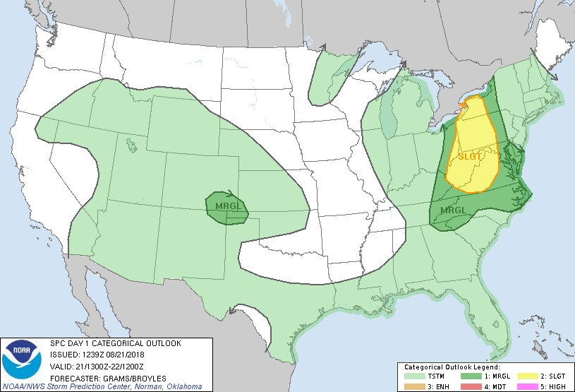
^^^^^however, SBCAPE is on the increase and with PWAT around 2.2 - 2.3 could still be an interesting late afternoon especially triangle westward....
B
Brick Tamland
Guest
Looks like it could be a repeat of the last couple of days here. The storms have been waiting to come through late at night and after midnight, though. Maybe we'll get them earlier today.
Let’s go ahead and get it out of the way before winter arrivesAuntie Em ...
View attachment 5651
There's something wrong here ...
View attachment 5652
View attachment 5653
Looks like winter came early.View attachment 5655 The memories of Sunday’s storm!
NC the big winner today! Getting all the winter catch phrases warmed up!Let’s go ahead and get it out of the way before winter arrives
Rates will overcome the shallow warm layerNC the big winner today! Getting all the winter catch phrases warmed up!
We’ve got some action rolling through the upstate. Hoping for a few token rain drops out of this one
I think I hate that one the worst, because it’s a bunch of BS, and NEVER works S of 85Rates will overcome the shallow warm layer
Currently the radar is about spot on what the HRRR was saying!! Gives me hope for winter!:weenie:HRRR says mby gets wrecked somewhere between 4-7 pm, we shall see!?
HRRRRRR will show r/s line north of 85 and we will say “that can’t be right. I expect the frozen line to be somewhere around Newberry.”Currently the radar is about spot on what the HRRR was saying!! Gives me hope for winter!:weenie:
On a more positive note, looks like I’m about to get fringed by some heavy rainfall

The ole Greenville county split! I’ll enjoy my .17 and and enjoy the next 12 dry days! #WINNINGOn a more positive note, looks like I’m about to get fringed by some heavy rainfall
Probably going to be another night where the best coverage is after 8pm and may maximize in the 10pm to 2am period for our corridor. This might mean our severe chances are isolated at best but with pwats through the roof flooding will be a bigger concern^^^^^however, SBCAPE is on the increase and with PWAT around 2.2 - 2.3 could still be an interesting late afternoon especially triangle westward....
Sent from my SM-G955U using Tapatalk
I lucked out in MBY. Getting hit with some of these smaller cells now. Need this luck to carry over into January
cd2play
Member
I picked up 1.5 on Friday and another 1.5 on Saturday, and probably another 0.4 since. #bigwet