Damn! Things have gotten so much better down there, once I moved up here and brought the rain shield! I swear I’ve been up here since July 31, it’s rained here 1 day, when the derecho came through
-
Hello, please take a minute to check out our awesome content, contributed by the wonderful members of our community. We hope you'll add your own thoughts and opinions by making a free account!
You are using an out of date browser. It may not display this or other websites correctly.
You should upgrade or use an alternative browser.
You should upgrade or use an alternative browser.
Pattern August Rush 2020
- Thread starter accu35
- Start date
Dennis Smith was excellent.
Damn that guy looks like me! What was his name? Dennis something, right?
Ninja’dDennis Smith was excellent.
NBAcentel
Member
Whose ready for a front loaded winter
NoSnowATL
Member
What’s Winter?Whose ready for a front loaded winter
I’m going to miss front loaded winters, and then chasing 10-15 day cold patterns into April!Whose ready for a front loaded winter
Onset ice
NBAcentel
Member
Onset ice
For the first time in a long time, I’m proud of you
That's actually not the hottest I've seen here lol
I hit 111° in San Angelo once.
NBAcentel
Member
Tomorrow makes me think about hailers 
NBAcentel
Member
Gfs really steepens mid level lapse rates this weekend into next week, wouldn’t surprise me if we get a day with solid hail with deep layer shear from the upper level trof
NBAcentel
Member
Saturday could be that day, steep mid level LRs (around 7C) along with a swath of 30-40kts of 500mb flow would definitely get the job done for hailers, long straight hodos confirm that (those Hodographs are favorable for large hail) 


NWS going with 80% storms here both Thu/Fri.
Dropped to 66 degrees this morning... 3 degrees below normal. What a cold shot! not... did break the over a month long streak of 70+ lows however.
NRVWX
Member
Death Valley made a run toward a record high today. View attachment 46546
Sure that wasn't in Jonesville SC? ??
NRVWX
Member
If you like circa 1985 radar technology.Weatherbug! FTW
51 degrees thus AM
Shaggy
Member
Starting back another rain streak? Its dumping buckets outside right now again.
Shaggy
Member
My 3rd time seeing flash flooding in 9 days. Epic rainfall right now over northern Greenville.
blueheronNC
Member
First pop-up shower forming directly overhead this summer. Didn’t know that was possible here.

GeorgiaGirl
Member
Ended up with over an inch from a good thunderstorm yesterday.
BTW: I am WAY late, but my July rain total was 8.78".
BTW: I am WAY late, but my July rain total was 8.78".
I know it’s not the southeast but wow.??
NBAcentel
Member
Make it stop 
Rained twice this morning .01 each time
Shaggy
Member
Rained twice this morning .01 each time
Water water everywhere down this way. Helluva a monsoon for a 20% day.
Attachments
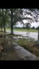

Wow. Have to say given the recent rain figure that 97 and 98L will find a way into the area in some fashionWater water everywhere down this way. Helluva a monsoon for a 20% day.
Avalanche
Member
Wow. Have to say given the recent rain figure that 97 and 98L will find a way into the area in some fashion
I certainly hope so, some of us haven't cashed in yet in spite of the widespread nature and frequency of the storms.

The next few days look solid especially if we can get a MCV to get going in S Ga one afternoon that would likely arrive here the next aftnI certainly hope so, some of us haven't cashed in yet in spite of the widespread nature and frequency of the storms.
NBAcentel
Member

NBAcentel
Member
Just realized there wasn’t a marginal today even with solid SBcape and 20-25kts of effective shear, makes sense lol 
smast16
Member
I thought we were done playing this game.

Iceagewhereartthou
Member
Big storm here in the upstate, already picked up an inch. Only poitive; its down to 63 degrees!

Nice storm just started
NBAcentel
Member
Nope 
NBAcentel
Member
I’m real slick lmao I accidentally posted on the 98L thread
Still incredible how my yard is the last place it gets to and the first place it clears. Maybe 10 mins worth of moderate rain. Still kind of disappointed.

Got some unreal shots from this storm. Will post


I was basically underneath a shelf cloud. Don't know what that lowering was. The top one is the best picture I have ever taken