• Hello, please take a minute to check out our awesome content, contributed by the wonderful members of our community. We hope you'll add your own thoughts and opinions by making a free account!

Pattern April Showers

1C00C28B-EAEC-44B3-A87E-DF1D136DC21B.png Verbatim, not gonna get it done.
 
Winter 2017-18: Please go home already. IT'S OVER! You gave much of the region a big snow in January. That alone made this winter a success. But now it's time to bid farewell (it was time 3 weeks ago) Winter, PLEASE leave before you mess around and snow-hole me!
 
0711CD10-9620-43DD-BA24-E50D64C461A3.png Ok, Roxboro scores, again!
 
As Jon mentioned, the ridge over the southwestern US, Great Basin, and Rockies matters a lot here too. I'm in favor of a stronger ridge out west and deeper trough near the lakes because it's already unusually hot and dry in the western US. Warmer air is less dense, takes up more space, and the heights rise (lower) above (below) a warm anomaly which is centered closer to 700 hPa here (which means the heights rise on the height surfaces above this level).

A moderate-extreme drought blankets most of the southwestern US and south-central plains and is largely to blame for the very intense elevated mixed layers (EMLs) that keep being advected eastward into the MS valley and SE US (let's just hope we continue to have unfavorable large-scale synoptic forcing because if we get a decent pattern for severe, it's going to strengthen the mid-level capping inversion that may allow storms to remain generally more discrete than we're accustomed to and this is often a feature that's present in many of the largest tornado outbreaks in the SE US).
View attachment 4924
View attachment 4923

The forecasted z500 configuration by day 4 (ridge over the west, trough centered near the Lakes and Hudson Bay) is strongly correlated with the DJFM mean pattern, it would not be shocking to see this anomalous wave configuration grow stronger on NWP as we get closer (which is inadvertently in favor of a more suppressed wave this weekend unlike what the GFS & ICON are showing atm)
View attachment 4925


While the MJO is not in favor of this trough-ridge configuration becoming more intense, tropical forcing has not been very effective at breaking through this broad -AAM anomaly (anomalous easterlies) in the mid-latitudes and subtropics the past few months, and this MJO event is actually being dynamically forced by breaking mid-latitude waves in the NE Pacific.
View attachment 4926

Here I crudely overlaid the juxtaposition of upper level anticyclones and cyclones on the week 1 CFSv2 forecast, and overlaid the propagation vector of this train of Rossby Waves in green, which points equatorward. Notice the upper level cyclonic anomaly this wave train has created just off the coast of South America. This upper level cyclonic anomaly usually leads (or is east of) the MJO's convective envelope and if you were to extrapolate this feature to the larger-scale global pattern, it actually says the MJO is in the West-central pacific (phase 7-8) right now which is exactly what we see in the RMM phase diagrams! The creation of the upper level cyclonic anomaly over the EP will increase upper level divergence to its west over the central pacific which is what you can clearly see happening near the international dateline.

View attachment 4927
View attachment 4928

View attachment 4929

While the MJO >>>> mid-latitude pathway is more widely recognized by the meteorological community since it's a decent high frequency analogue to ENSO and was what I was taught in my synoptic class, isn't it cool to see how things operate the other way around, with extratropical waves forcing the MJO?! This new and/or temporary MJO pulse generated by the breaking extratropical waves in the N Pacific will go onto produce another series of diabatically-induced mid-latitude wave trains (or mid-latitude wave packets) that will radiate poleward and eastward at the Rossby Waves' group velocity and those waves could also propagate into the tropics and continue to sustain or even thwart the MJO through the processes I briefly glossed over above. This is why some consider the MJO to be a self sufficient phenomenon which evolves together simultaneously with the mid-latitude pattern as opposed to the more canonical one-dimensional view of the MJO forcing the wave trains and remaining unaffected by Rossby wave breaking into the subtropics.

Big surprise, the 0z GFS takes a step towards this solution which is supported by the Euro camp w/ a bigger ridge out west and deeper trough near the Lakes. The current BL conditions and long-standing planetary wave pattern would favor this over its previous solutions.
Unknown.gif
 
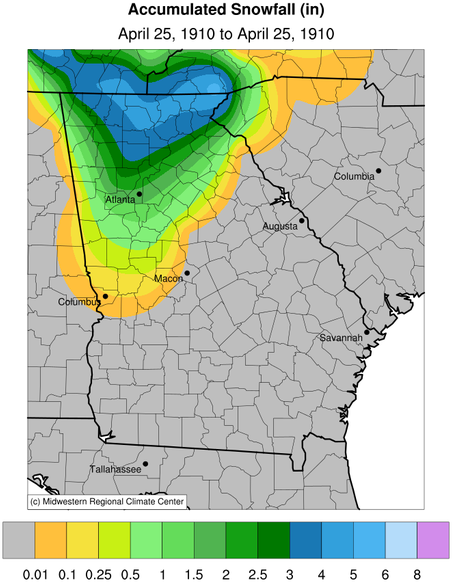
the latest accumulating snow for Chattanooga I can find is April 25, 1910... 4.1 inches.. also happens to be the highest April total as well. Could be a measurement error, or all melted as it fell.. no idea, no information on this bizarre event. The temps were well into the 70s and 80s before this late cold snap, so Spring was in full bloom. The high/low on 4-25-10 was 39/32. Okay, here's a little more on it: 1.5 inches fell in Atlanta.
snowfall-ga-4-25-1910.png
https://site.extension.uga.edu/climate/2017/04/april-25-1910-snowfall-in-northern-georgia/
 
Last edited:
The Icon is still the furthest North of the runs so far tonight, also warmest... I guess in terms of climatology it makes sense, but this is record cold for Minnesota, not your ordinary late season cold air mass, ie, could do weird things.
 
dayum, 1040 High in Montana on the 06z..... strongest yet I think. Pretty intense April Canadian high pressure dome boys and girls..
gfs_mslp_pcpn_frzn_us_14.png
 
still a Kentucky/Va storm at this point.. looking like this is the likely track I guess..
 
If the low track shifts too far north into VA and the mid-Atlantic, definitely have to be a little more concerned about the potential for severe weather/general thunderstorms rather than cold rain or snow in the Carolinas. For ex, the latest ECMWF w/ the low tracking thru SC is making things interesting for the south-central coastal plain & SE coastal areas of NC... If the model shifts north again, so does the warm front and the attendant surface based CAPE

29995785_599459420399781_1575798876_o.png
30069878_599459413733115_384490961_o.png
 
If the low track shifts too far north into VA and the mid-Atlantic, definitely have to be a little more concerned about the potential for severe weather/general thunderstorms rather than cold rain or snow in the Carolinas. For ex, the latest ECMWF w/ the low tracking thru SC is making things interesting for the south-central coastal plain & SE coastal areas of NC... If the model shifts north again, so does the warm front and the attendant surface based CAPE

View attachment 4936
View attachment 4935
Its crazy to know you can go from a snowstorm to a severe weather in the models so quick.
 
I've seen enough to give up on the 100+ year SE US cold rain/wintry event possibility on 4/7. Yesterday, both the 0Z & 6Z GFS runs had a very weak low cross N FL underneath an Arctic high, highly unusual for this late in the season and thus producing the 100+ year April inland SE wintry/coastal SE cold rain. Also, the 12Z Euro had a very weak low cross S GA. However, today's 0Z/6Z runs pretty much all have any low crossing C or N GA. There have now been 4 GFS runs in a row without anything even close to the 0Z/6Z GFS runs of yesterday.
 
So, right now the models seem to still be all over the place. GFS goes back south again to the Euro. Lots of changes and inconsistency still with the model runs.
 
To show the drastic GFS change: yesterday's 0Z/6Z GFS runs, when the low crossed N FL underneath an Arctic high, had at Columbia an historic significant mainly ZR/IP wedge induced winter storm, the likes of which hasn't been seen in April there since at least 1915 and which would have made many Columbian wintry fans very happy. Today's 6Z has about that same amount of precip (0.50") but with temperatures in the 60s and a high of 80 just preceding the rain.

Edit: The track of the surface low on the 12Z GFS is a whopping 300 miles north of the track on yesterday's 0Z and 6Z GFS runs.
This historic goose looks cooked to me. Besides, it was historic there on only those 2 runs. Prior to those runs, the GFS had nothing even close to historic at Columbia. So, the two runs were the equivalent of just a blip at Columbia.
 
Last edited:
If there's just a little more CAPE and the synoptic setup remains generally similar or even improves some, things could get interesting wrt severe in portions of the Carolinas.
sfcwind_mslp.us_ma.png

bs0500.us_ma.png
srh03.us_ma.png
lr75.us_ma.png
mucape.us_ma.png
 
It's amazing how much the sensible impacts from the storm this weekend change just from a minute alteration in the placement and intensity of the northern stream s/ws pinwheeling around the base of the SE Canada cyclonic gyre. 30s/40s and cold rain mixed w/ snow/sleet in the cold sector to 60s & 70s in the warm sector w/ the potential for a few severe storms or heavy thunderstorms if more CAPE is realized.
Unknown.gif
 
UK has weak low in the Deep South at day 4. Wonder how much timing of this wave has to do with how far north it tracks.
 
A secondary wave develops on the front and slings moisture back across the cold front in NC leading to snow on the backend for the same areas that were in the 60s/70s just several hours prior.
index.php.png
 
Some of the most recent models are suggesting a significant snowfall at DC. Going back to 1925, the most in April has been only 0.6". So, there is a chance for this to be exceeded. The highest on record in April is the 5.5" of 1924.

The highest monthly total of this season to date has been the 4.5" of March. Has DCA ever had its heaviest monthly in April? That did occur in 1889 (4.0"). Also, the 3.5" of April of 1915 tied with Dec of 1914.
 
I wouldn't ride the UKMET. It's been too far south it seems all winter.

UK was really good for the January events, if I recall correctly. But, was bad with last weeks event. All models have struggled outside of day 4 all winter. We will see what tomorrow’s runs show. With such a cold airmass it will be a great event for whoever sees snow.
 
So, right now the models seem to still be all over the place. GFS goes back south again to the Euro. Lots of changes and inconsistency still with the model runs.
If I'm not mistaken, the gfs is north than prior runs. Really doesn't look good for NC, maybe mountains. Looking great for Kentucky and the Virginia.
 
Anyone surprised JB is literally saying the best snows mighy end up right in his backyard lol
b3e7b7c3d42c940dcac4f75836bffd3e.jpg


Sent from my SM-J327VPP using Tapatalk
 
Anyone surprised JB is literally saying the best snows mighy end up right in his backyard lol
b3e7b7c3d42c940dcac4f75836bffd3e.jpg


Sent from my SM-J327VPP using Tapatalk
JB knows he sucks at snow. He’s been on the outside looking in all winter
 
last weeks system shifted south a little late so I am going to be a :weenie: and still hope. CMC ok and 18z ICON is south so there is still weenie hope.
 
Local weather now mentions possible light snow for northern middle Tennessee this weekend. It’s been cool to see snow so many times this late in the season but at the same time a little hard watching places 50-75 miles north of me pick up 3-5 inches of snow multiple times in March. This event looks like the same thing is going to happen possibly where I’m on the outside looking in at bigger totals just to my north. Either way it pretty amazing and this very easily could end up the heaviest snow I’ve seen this late in the season even if it’s only a dusting. Most I’ve seen before in April was tiny dandruff flakes with no accumulation.
 
I wish just one time the models could lock in on a southeast snowstorm 7 days out and keep it all the way in. I mean, I know that’s not realistic and I don’t expect it, especially in April, and especially when we need a south trend. You can’t hardly buy a south trend in the dead of winter, much less mid-April.
 
Back
Top