• Hello, please take a minute to check out our awesome content, contributed by the wonderful members of our community. We hope you'll add your own thoughts and opinions by making a free account!

Tropical 92L

Yeah I get you on that, but it's still going to be getting hit hard unless it's going almost due east, which seems unlikely. I wouldn't say a cat 1 is out of the question, maybe a 2 if everything was perfect, but it still looks like too much shear to me to get a big dog.

Really don't see that much shear over the system at all, at least looking at the GFS.
 
Really don't see that much shear over the system at all, at least looking at the GFS.
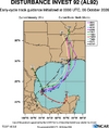
I am taking the GFS as gain and salt right now...too bullish for me like other systems it has produce only to be downgraded in future runs.
 
GFS not as crazy this run. Strong TS landfall near New Orleans
Slower moving storm= blasted by shear by the time it hooks to the north late Saturday. Makes landfall Sunday.
Faster moving storm= movies in tandem with the trough and jet helps ventilate (therefore helps it intensify). Already makes landfall by Saturday.
 
0Z UKMET: landfall ~175 miles W of 12Z run with it near far SE LA and then MS. Strongest run yet with high end TS/990 mb:

NEW TROPICAL CYCLONE FORECAST TO DEVELOP AFTER 54 HOURS
FORECAST POSITION AT T+ 54 : 22.2N 92.1W

LEAD CENTRAL MAXIMUM WIND
VERIFYING TIME TIME POSITION PRESSURE (MB) SPEED (KNOTS)
-------------- ---- -------- ------------- -------------
1200UTC 08.10.2026 60 22.7N 91.7W 1003 30
0000UTC 09.10.2026 72 22.9N 89.9W 1001 30
1200UTC 09.10.2026 84 25.4N 88.6W 999 39
0000UTC 10.10.2026 96 26.4N 88.5W 997 48
1200UTC 10.10.2026 108 29.2N 88.7W 990 58
0000UTC 11.10.2026 120 32.1N 89.5W 992 29
1200UTC 11.10.2026 132 33.8N 88.8W 1002 25
0000UTC 12.10.2026 144 38.4N 83.2W 1003 12
1200UTC 12.10.2026 156 CEASED TRACKING
 
0Z UKMET: landfall ~175 miles W of 12Z run with it near far SE LA and then MS. Strongest run yet with high end TS/990 mb:

NEW TROPICAL CYCLONE FORECAST TO DEVELOP AFTER 54 HOURS
FORECAST POSITION AT T+ 54 : 22.2N 92.1W

LEAD CENTRAL MAXIMUM WIND
VERIFYING TIME TIME POSITION PRESSURE (MB) SPEED (KNOTS)
-------------- ---- -------- ------------- -------------
1200UTC 08.10.2026 60 22.7N 91.7W 1003 30
0000UTC 09.10.2026 72 22.9N 89.9W 1001 30
1200UTC 09.10.2026 84 25.4N 88.6W 999 39
0000UTC 10.10.2026 96 26.4N 88.5W 997 48
1200UTC 10.10.2026 108 29.2N 88.7W 990 58
0000UTC 11.10.2026 120 32.1N 89.5W 992 29
1200UTC 11.10.2026 132 33.8N 88.8W 1002 25
0000UTC 12.10.2026 144 38.4N 83.2W 1003 12
1200UTC 12.10.2026 156 CEASED TRACKING
Wow!! UK has been very consistent so far.
 
0Z UKMET: landfall ~175 miles W of 12Z run with it near far SE LA and then MS. Strongest run yet with high end TS/990 mb:

NEW TROPICAL CYCLONE FORECAST TO DEVELOP AFTER 54 HOURS
FORECAST POSITION AT T+ 54 : 22.2N 92.1W

LEAD CENTRAL MAXIMUM WIND
VERIFYING TIME TIME POSITION PRESSURE (MB) SPEED (KNOTS)
-------------- ---- -------- ------------- -------------
1200UTC 08.10.2026 60 22.7N 91.7W 1003 30
0000UTC 09.10.2026 72 22.9N 89.9W 1001 30
1200UTC 09.10.2026 84 25.4N 88.6W 999 39
0000UTC 10.10.2026 96 26.4N 88.5W 997 48
1200UTC 10.10.2026 108 29.2N 88.7W 990 58
0000UTC 11.10.2026 120 32.1N 89.5W 992 29
1200UTC 11.10.2026 132 33.8N 88.8W 1002 25
0000UTC 12.10.2026 144 38.4N 83.2W 1003 12
1200UTC 12.10.2026 156 CEASED TRACKING
1791261935895.png
 
Back
Top