Shaggy
Member
Most models are calling for another inch or two around here, but I'm skeptical, looking at the radar. Upstream returns are fairly paltry.Models had done pretty good showing this rain minimum down along I95.
2.39 hereWow! You all are getting soaked, 7-8 inches. 2.8 is my total since Monday. Curious to hear some RDU totals.
We are definitely a bit soggy here.Wow! You all are getting soaked, 7-8 inches. 2.8 is my total since Monday. Curious to hear some RDU totals.
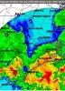
BIG moisture plume coming off the Atlantic will dump on areas of NC from Raleigh north and east. You can see a little meso low, on radar, spinning as it traverses NW. Also some lightning returns showing up.
I’ll tell you what the HRRR and HRRRX 12z really showing some good severe weather setting up tomorrow .. should be quite interesting


As usual the Euro was impressive...
Mondays 12z run compared to actual
View attachment 41820View attachment 41821
Severe Thunder Storm Warnings being issued in NC
Wouldn't be surprised to see the sun shortly. Probably one last line of storms for this area later today.
Paging @isoWho is the warning coordinator for the GSP WFO? I swear they warn for arguably general thunderstorms, what’s more concerning is the excessive sizes of the polygons, lol
The axis of the rain the last couple of days has been very isolated to a degree. For instance, here in the Midlands, we were supposed to have our wettest day of this rain stretch yesterday. Instead, most areas only saw 0.10-0.50 in the immediate Columbia area. We were supposed to get 1-2 inches of rain. They even extended the flash flood watch into this area, but nothing really materialized. So really, who ever got hit, got hit hard. But everyone else probably had around 2-4 inches of rain. My location has got 2.60 from this entire event.Glad it’s there and not over Charlotte wow there would be serious issues. I wonder what went wrong today with lack of rain further west, they still got that flash flood watch but nothing is happening?
As much as it’s rained here this week it would only take about 3 sprinkles to flood even more areas. Probably why they still have those hoisted.Glad it’s there and not over Charlotte wow there would be serious issues. I wonder what went wrong today with lack of rain further west, they still got that flash flood watch but nothing is happening?