Guess I can't post what I think.
That’s what a weather boards for. Please continue to post what you think. Most people appreciate it
Sent from my iPhone using Tapatalk
Guess I can't post what I think.

I am in the top bubble and have to say the sun is out bright, it’s sticky, and it has that classic feel. I feel this would be a pretty significant event today if only we had the wind shear in place.My thoughts on your best tornado chances are in the top most Buble today. Lower buble is your bowing segment multicluster updrafts, could be a spin up sure?. But it'll only happen when instability is diminishing as the sun goes down and the nocturnal increase in windshear begins.
Your best mix for low-moderate shear and high instability is north of Atlanta. View attachment 116894
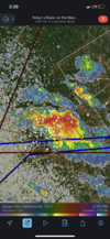
It appears that it will slide just north of Cordele, maybe.Tornado warning south GA
View attachment 116904
Right over Georgia Veterans Sate Park and Lake Blackshear.That one in South Georgia is about to go right over my parents home in Cordele.
