lj0109
Member
Public Information Statement
National Weather Service Columbia SC
1106 PM EDT Mon Apr 13 2020
...NWS DAMAGE SURVEY FOR APRIL 13, 2020 TORNADO EVENT...
...BARNWELL TO ORANGEBURG TO CALHOUN COUNTY EF-3 TORNADO...
Start Location...2 ENE Elko in Barnwell County SC
End Location...8 WSW St. Matthews in Calhoun County SC
Date...04/13/2020
Estimated Time...05:46 AM EDT
Maximum EF-Scale Rating...EF3
Estimated Maximum Wind Speed...140 mph
Maximum Path Width...770.0 yards
Path Length...31.55 miles
Beginning Lat/Lon...33.3814 / -81.3481
Ending Lat/Lon...33.624 / -80.9115
* Fatalities...2
* Injuries...7
...Summary...
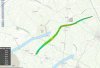
A strong, long-track tornado began just east of the town of Elko
in Barnwell County , then moved in a general northeast direction
through Orangeburg County, before dissipating southwest of St.
Matthews in Calhoun County before reaching I-26. The tornado path
length was over 31 miles, and at its widest point was just under
0.5 miles. The tornado was rated an EF-3, with peak wind speeds
of 140 mph. There were 2 confirmed fatalities with at least
7 injured.
The tornado began near Willis Pond Rd. Along its entire path,
there was widespread tree damage. The tornado strengthened as it
approached SC Highway 3 and Gardenia Rd., where it destroyed and
tossed a wood framed home anchored to the ground, lifted a
significant portion of a roof on a brick home, destroyed a fifth
wheel camper, and knocked over a pivot irrigation system. The
tornado then crossed Norway Rd. where it snapped multiple power
poles. As the tornado reached Fire Tower Rd. west of Neeses, it
intensified further, destroying 3 anchored manufactured homes on
Preserver Rd. near Ninety Six Rd. It was in this area that the 2
known fatalities occurred to residents in a double-wide
manufactured home.
The tornado then turned more eastward, crossing Savannah Highway
and Dragstrip Rd north of Livingston. There were several homes or
manufactured homes that were heavily damaged or destroyed in this
area. The tornado gradually weakened as it crossed North Rd. and
dissipated as it crossed into Calhoun County.
National Weather Service Columbia SC
1106 PM EDT Mon Apr 13 2020
...NWS DAMAGE SURVEY FOR APRIL 13, 2020 TORNADO EVENT...
...BARNWELL TO ORANGEBURG TO CALHOUN COUNTY EF-3 TORNADO...
Start Location...2 ENE Elko in Barnwell County SC
End Location...8 WSW St. Matthews in Calhoun County SC
Date...04/13/2020
Estimated Time...05:46 AM EDT
Maximum EF-Scale Rating...EF3
Estimated Maximum Wind Speed...140 mph
Maximum Path Width...770.0 yards
Path Length...31.55 miles
Beginning Lat/Lon...33.3814 / -81.3481
Ending Lat/Lon...33.624 / -80.9115
* Fatalities...2
* Injuries...7
...Summary...
A strong, long-track tornado began just east of the town of Elko
in Barnwell County , then moved in a general northeast direction
through Orangeburg County, before dissipating southwest of St.
Matthews in Calhoun County before reaching I-26. The tornado path
length was over 31 miles, and at its widest point was just under
0.5 miles. The tornado was rated an EF-3, with peak wind speeds
of 140 mph. There were 2 confirmed fatalities with at least
7 injured.
The tornado began near Willis Pond Rd. Along its entire path,
there was widespread tree damage. The tornado strengthened as it
approached SC Highway 3 and Gardenia Rd., where it destroyed and
tossed a wood framed home anchored to the ground, lifted a
significant portion of a roof on a brick home, destroyed a fifth
wheel camper, and knocked over a pivot irrigation system. The
tornado then crossed Norway Rd. where it snapped multiple power
poles. As the tornado reached Fire Tower Rd. west of Neeses, it
intensified further, destroying 3 anchored manufactured homes on
Preserver Rd. near Ninety Six Rd. It was in this area that the 2
known fatalities occurred to residents in a double-wide
manufactured home.
The tornado then turned more eastward, crossing Savannah Highway
and Dragstrip Rd north of Livingston. There were several homes or
manufactured homes that were heavily damaged or destroyed in this
area. The tornado gradually weakened as it crossed North Rd. and
dissipated as it crossed into Calhoun County.