Western cell may go tornado warned soon
-
Hello, please take a minute to check out our awesome content, contributed by the wonderful members of our community. We hope you'll add your own thoughts and opinions by making a free account!
You are using an out of date browser. It may not display this or other websites correctly.
You should upgrade or use an alternative browser.
You should upgrade or use an alternative browser.
Severe 3/30-4/2 Severe Weather
- Thread starter SD
- Start date
^^^Im out and about in Apex, looks like will miss it east.
blueheronNC
Member
blueheronNC
Member
jovialweather
Member
Shaggy
Member
Yeah bet we see a developing CC drop and A confirmed tornado
Downeastnc
Member
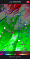
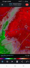
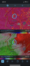
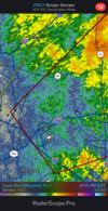
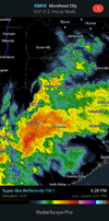
It was pretty tight for a few frames, probably legit OTG for a mile or two based on CC drop
Bannerdude
Member
It was pretty tight for a few frames, probably legit OTG for a mile or two based on CC drop
That was right where 540-40 intersect, office parks everywhere. Hope not.....
- Joined
- Jan 23, 2021
- Messages
- 4,595
- Reaction score
- 15,183
- Location
- Lebanon Township, Durham County NC
Latest RDU Metar(19:51) doesnt seem like anything out of the way.
Downeastnc
Member
Might be trying to tighten up again might try again in the next 5-10 mins....
RDU METAR reported funnel
Wral saying reports of a confirmed touchdown
- Joined
- Jan 23, 2021
- Messages
- 4,595
- Reaction score
- 15,183
- Location
- Lebanon Township, Durham County NC
oh **** the next one sure did:RDU METAR reported funnel
METAR text: | KRDU 311957Z 21028G43KT 1SM FC +RA BR FEW006 SCT014 OVC030 20/19 A2962 RMK FUNNEL CLOUD B56 AO2 PK WND 21043/1956 PRESRR P0003 T02000189 |
Conditions at: | KRDU (RALEIGH/DURHAM , NC, US) observed 1957 UTC 31 March 2022 |
Temperature: | 20.0°C (68°F) |
Dewpoint: | 18.9°C (66°F) [RH = 93%] |
Pressure (altimeter): | 29.62 inches Hg (1003.1 mb) |
Winds: | from the SSW (210 degrees) at 32 MPH (28 knots; 14.4 m/s) gusting to 49 MPH (43 knots; 22.1 m/s) |
Visibility: | 1.00 miles (1.61 km) |
Ceiling: | 3000 feet AGL |
Clouds: | few clouds at 600 feet AGL scattered clouds at 1400 feet AGL overcast cloud deck at 3000 feet AGL |
Weather: | FC +RA BR (funnel cloud, heavy rain, mist) |
blueheronNC
Member
Downeastnc
Member
Wral saying reports of a confirmed touchdown
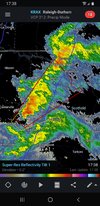
CC drop was pretty clear, probably weak small fast moving tornado, maybe off and on the ground 4-6 mins based on radar....its also getting ready to do it again....
blueheronNC
Member
Wondering if atmosphere can recover enough that more storms go up as the front brings better forcing. One storm back in boone
blueheronNC
Member
Steven_1974
Member
Yikes, that wasn't too far away from where I work.
Downeastnc
Member
Gusting into the 40's here now....PGV
| Wind Speed | S 22 G 43 mph |
pcbjr
Member
Downeastnc
Member
Downeastnc
Member
HRRR makes that band down by ILM interesting as it move north over eastern NC over the next few hrs....
Downeastnc
Member
Looked pretty good just NE of Castalia for a frame, better hope it is not cycling, rotation should go between Halifax and Weldon....or pretty darn close to you.....
I'll be on the front porchLooked pretty good just NE of Castalia for a frame, better hope it is not cycling, rotation should go between Halifax and Weldon....or pretty darn close to you.....
Weakening considerably
Well that was a nothing burger, headed to the gym.Weakening considerably
Downeastnc
Member
I think the storm figured out that you were a Moderator here & weakened the Mesocyclone to avoid being banned by you. ?Well that was a nothing burger, headed to the gym.
Will be interesting to see if a survey is done to confirm if tornado was on ground at 540/40 near RDU.
Also heard of possible funnel cloud spotted at Boyce Mill Rd near Wake/Durham line from a different cell around the same time. That one wasn't a trained spotter though, so take with a grain of salt. (not ruling it out either)
Also heard of possible funnel cloud spotted at Boyce Mill Rd near Wake/Durham line from a different cell around the same time. That one wasn't a trained spotter though, so take with a grain of salt. (not ruling it out either)
HSVweather
Member
Z
Zander98al
Guest
I was surprised we actually had action here yesterday since we didn't have any sun ahead of time. The tornado hit close to where my office used to be. I was worried when they had Wake Forest in the warning, and my kids were at home with my mom.
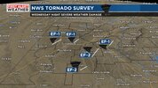
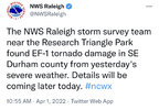
EF1 confirmed for a 1/4 mile.
EF2 also reported in Anson county.
EF2 also reported in Anson county.

