New year will be here soon
-
Hello, please take a minute to check out our awesome content, contributed by the wonderful members of our community. We hope you'll add your own thoughts and opinions by making a free account!
You are using an out of date browser. It may not display this or other websites correctly.
You should upgrade or use an alternative browser.
You should upgrade or use an alternative browser.
Severe 2026 Severe Thread 🌩
- Thread starter SD
- Start date
Cad Wedge NC
Member
Oh look the annual, way to early, jinx severe season thread.
NWMSGuy
Member
Could be looking at some severe potential developing on Friday for the Mid-South
SPC:
D6/Friday still appears to have the best relative severe potential,
despite the pair of GEFS-based ML guidance trending lower and in
areal extent of 5 percent peak probs. Neither of these have any
appreciable overlap with the preferred ECENS-based 5 percent areas
from NCAR. In any case, an amplified upper trough appears likely to
shift from around the Rockies to the Great Plains. Most EC-AIFS ENS
members now support central states cyclogenesis. But predictability
remains low regarding the spatiotemporal details and amplitude of
cyclogenesis, which is likely related to the handling of shortwave
impulses embedded within the broader trough. An area-of-interest for
a future 15 percent severe highlight roughly includes the Lower MS
to TN Valleys and Deep South.
NWS Memphis:
All signs point to a potential severe weather setup on Friday as
this system continues east, but several caveats exist. The best
forcing with this system remains displaced to our north, away
from the greatest dewpoints. In addition, ensembles struggle with
advecting appreciable CAPE into our region with the GEFS only
showing a 10% chance of >500 J/kg of SBCAPE reaching into north
Mississippi. This would yield a high shear, low CAPE
environmental setup, which is typical for this time of year. I
will note that the latest EFI/SOT did increase slightly from
yesterday, meaning there is a tad more confidence in severe
potential Friday. In addition, both CSU and CIPS machine learning
models are beginning to pick up on this potential. For now,
expect the end of the week to be rainy with thunderstorms.
Further severe weather details will be ironed out in the coming
days.
NBAcentel
Member
Probably gonna need a severe thread for this. Looks like your typical setup where a supercell or 2 goes crazy along some sort of surface feature/just south of the grunge/stratiform. Flow is SWly aloft but the forcing is somewhat removed. Kinda interesting 


BufordWX
Member
HRRR showing some impressive rain totals tonight into tomorrow. Isolated severe weather threat as well.
Fascinated to see how this turns out overnight. WPC still has the slight risk of excessive rainfall northwest of metro AtlantaHRRR showing some impressive rain totals tonight into tomorrow. Isolated severe weather threat as well.View attachment 182084
HRRR going stupid with rain overnight. Surely this is way overdone?

BufordWX
Member
Looks like storms are starting to rotate back in Louisiana.
Brent
Member
Hopefully Alabama isn't going to do what we did Thursday morning around sunrise
Had 5 tornadoes confirmed apparently. Tied the record for January in 2 hours before 9am
Had 5 tornadoes confirmed apparently. Tied the record for January in 2 hours before 9am
NCWeatherNow
Member
BufordWX
Member
Tornado warning north of Montgomery. 
NCWeatherNow
Member
BufordWX
Member
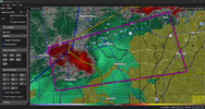
Instability will be a bit less further north, but there is a small surge in the line coming into Carroll county. Something to watch.
BufordWX
Member
Brief tornado not out of the question with this.Instability will be a bit less further north, but there is a small surge in the line coming into Carroll county. Something to watch.View attachment 182179

BufordWX
Member
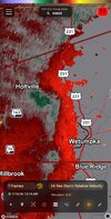
CC drop?Brief tornado not out of the question with this.View attachment 182188

Edit: Yes. Although probably the tornado was very brief and already lifted.

Definitely. What is FFC doing?

BufordWX
Member
Surprised they didn’t even have a tornado possible severe thunderstorm in the leadup to that.Definitely. What is FFC doing? View attachment 182190
BufordWX
Member
Another couplet just north of Newnan.
Yeah that was kinda a tough miss. Hope no one got hurtSurprised they didn’t even have a tornado possible severe thunderstorm in the leadup to that.
NewnanWetather
Member
I live in Newnan right at the Carroll border. No damage was reported except some downed trees. It was by far the oddest tornado I ever heard of. Came literally out of nowhere. The wind was wild. Sirens going off and the animals howling. Thankfully no injuries in Coweta.Yeah that was kinda a tough miss. Hope no one got hurt
BufordWX
Member
SPC making changes to the day 1-3 convective outlooks starting on or about March 2nd. Adding new levels of hatched risks and 75% and 90% wind probabilities.
Read more about it here:
Changes to Storm Prediction Center (SPC) Day 1, 2, and 3 Convective Outlook Probabilities of Significant Severe Hazards on or about March 2, 2026
Read more about it here:
Changes to Storm Prediction Center (SPC) Day 1, 2, and 3 Convective Outlook Probabilities of Significant Severe Hazards on or about March 2, 2026
HailCore
Member
Looks like this weekend has the potential for another severe weather outbreak across parts of the SE. Both GFS and Euro are showing severe weather between Friday and Sunday, but with 2 different scenarios and placements that have yet to adjust together into one specific idea.
Yeah the 12z Euro had moisture much further north compared to recent runsLooks like this weekend has the potential for another severe weather outbreak across parts of the SE. Both GFS and Euro are showing severe weather between Friday and Sunday, but with 2 different scenarios and placements that have yet to adjust together into one specific idea.

BufordWX
Member
Still a bit out there but March 4th-11th is looking quite active for severe weather.
Already a 15% risk area for parts of TX/OK for the 4th.
Already a 15% risk area for parts of TX/OK for the 4th.
Funny how this is happening and the new SPC outlooks start 3/3. What did they know lolStill a bit out there but March 4th-11th is looking quite active for severe weather.
Already a 15% risk area for parts of TX/OK for the 4th.View attachment 194598
Severe printer went brrr on the 12z GFS and Euro
BufordWX
Member
might be something lurking way out there near D10 for Dixie


jmills152077
Member
Really interested in the time period of the 11th - 12th for the SE. A lot will ride on how amplified the SE ridge is.
BufordWX
Member
New SPC outlooks start tomorrow with the 1630z day 1 outlook.
New SPC outlooks start tomorrow with the 1630z day 1 outlook.
Let me guess, now we have 8 risk levels, Marginal, Somewhat, Slight, Elevated, moderate, Uh-oh, High, You gonna Die.
So excited we’re kicking off severe season in the middle of winter! 

Brent
Member
March coming in like a lion for the Plains


