"
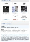
Friday night is where the mess begins. Models still on track for
the most part with bringing precip in from the west in
associating with the upper trough strengthening. Temperatures
will remain above freezing through Midnight across the entire
forecast area. Top down tools indicate that the rain should
become a rain/snow mixture across the northern Midlands towards
03z, then spread further south from that time on. With the onset
of the mixed precip, temperatures still above freezing, so
little to no accumulations expected. As we go past Midnight,
temperatures will near and eventually drop below freezing. At
the same time the rain/snow mixture may change over to all snow
across the Extreme northern Midlands/Pee Dee. Latest snowfall
total projections bring just a little above an inch across
portions of Lancaster and Chesterfield counties, with part of
that total being the initial amounts that would melt away. Even
so, those areas should be around 1 inch, while areas across the
Central Midlands may see around 0.5 inches now. The CSRA still
looking to receive either zero snow, or only trace amounts.
Still a lot of uncertainty, mainly due to the final track of the
offshore surface low, along with the strength and amount of
moisture from the upper trough as it moves through. Expect that
a Winter Weather Advisory is going to be needed at some point in
the future, but will allow the evening/night shifts time to
analyze the 00z guidance later tonight first. Northwest winds
will increase during the evening so a few gusts to above 20 mph
possible with strong cold advection. Temperatures should fall
into the 25 to 30 degree range by morning."
^
I will miss you. Final update with snow in my area, that will quickly be trimmed away at 00z.

