The model consensus is continuing to suggest that the N Gulf coast is at highest risk from a landfall from the follow-up system to TD 25, currently in the E. Caribbean, which would later likely lead to strong effects for many forum members well inland within 10/10-15.
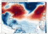
Here are two Gulf SST maps to show how much warmer it was with Michael's approach in 2018 vs now:
October 5, 2018: N Gulf all the way to the coast was 29-30 C (near 29C at the coast) or near an early Oct. record of ~85 F thanks to record SE US heat the prior two weeks. Note that SSTs off of SW FL were also near 29-30 C (~85 F):

In sharp contrast for the N Gulf, the October 1, 2020 map shows SSTs mainly in the 26-28 C range (near 26 C at the coast) or an average near 81 F meaning ~4 F cooler than it was on Michael's approach. And if anything, they'll likely cool down over the next week due to a cool next few days. So, if there were a H approaching the N Gulf coast in about a week, it would be traveling over much cooler water vs what Michael encountered as it approached the coast. Therefore, whereas there could still be a formidable H hitting the N Gulf coast and it be a big deal there and inland, the chance of it being anything near as strong as the historic Michael is between slim and none.
However, if a H were to approach SW FL south of Ft. Myers, where SSTs are 29-30 C, the fuel would be about the same as that of 2018 and the W Caribbean is actually ~ 2 F warmer at 30-31 C instead of 29-30 C:

Here are two Gulf SST maps to show how much warmer it was with Michael's approach in 2018 vs now:
October 5, 2018: N Gulf all the way to the coast was 29-30 C (near 29C at the coast) or near an early Oct. record of ~85 F thanks to record SE US heat the prior two weeks. Note that SSTs off of SW FL were also near 29-30 C (~85 F):
In sharp contrast for the N Gulf, the October 1, 2020 map shows SSTs mainly in the 26-28 C range (near 26 C at the coast) or an average near 81 F meaning ~4 F cooler than it was on Michael's approach. And if anything, they'll likely cool down over the next week due to a cool next few days. So, if there were a H approaching the N Gulf coast in about a week, it would be traveling over much cooler water vs what Michael encountered as it approached the coast. Therefore, whereas there could still be a formidable H hitting the N Gulf coast and it be a big deal there and inland, the chance of it being anything near as strong as the historic Michael is between slim and none.
However, if a H were to approach SW FL south of Ft. Myers, where SSTs are 29-30 C, the fuel would be about the same as that of 2018 and the W Caribbean is actually ~ 2 F warmer at 30-31 C instead of 29-30 C:
Last edited: