-
Hello, please take a minute to check out our awesome content, contributed by the wonderful members of our community. We hope you'll add your own thoughts and opinions by making a free account!
You are using an out of date browser. It may not display this or other websites correctly.
You should upgrade or use an alternative browser.
You should upgrade or use an alternative browser.


Who wants a dusting on top of what they already got?

Last edited:
BrickTamland
Member
Roofus going big. Euro with an inch to 1.5 inches here, too. Would love to see the short term models come in like that.
What the deuce is going on? Wake up to this mess.

EDIT: I miss golfing, need this mess gone asap. Where is my 60s, I thought February was a spring month anymore? You know, with all the "warming" and stuff, it can't possibly snow in the SE in February, right?
Sent from my iPhone using Tapatalk

EDIT: I miss golfing, need this mess gone asap. Where is my 60s, I thought February was a spring month anymore? You know, with all the "warming" and stuff, it can't possibly snow in the SE in February, right?
Sent from my iPhone using Tapatalk
Last edited:
WolfpackHomer91
Member


Pic 1 - 7PM
Pic 2 - 9PM (Diff Station)
Pic 3 - 11PM
Ummm
 that kind of looks like a 2-4” thing to me 85 N/W
 Sent from my iPhone using Tapatalk
0z and 6z Google WeatherNext fwiw


Euro AI slight shift north

Long range HRRR has some mixing and not very impressed but it's lr HRRR so.

I think it depends on just how strong the wave developing along the front can get. It has trended stronger, dusting to an inch seems legit. Don't think we get a bigger surprise than that
a_gilmore88
Member


Pic 1 - 7PM
Pic 2 - 9PM (Diff Station)
Pic 3 - 11PM
Ummmthat kind of looks like a 2-4” thing to me 85 N/W
Sent from my iPhone using Tapatalk
Don’t want anything to do with sleet/zr. If it’s not gonna be snow, just give me rain so my driveway can keep melting
blueheronNC
Member
Models trending toward a Roxboro Special

LukeBarrette
im north of 90% of people on here so yeah
Meteorology Student
Member
2024 Supporter
2017-2023 Supporter

This sounding is not very encouraging for snow...
BrickTamland
Member
One thing about this model is it doesn't bounce around much. Even the Euro bounces around more than it.
i'm totally tapped out man. i still have 2 inches of concrete from the previous weekend's storm. does look like somebody will get a quick band of wet snow, but after last few weeks it feels like small potatoes
BrickTamland
Member

BrickTamland
Member
GFS at 42.

BrickTamland
Member

BrickTamland
Member
RAP totals

BrickTamland
Member
Canadian

a canadian ray of hope for some of you i-40-north folks

at a glance i would expect the Canadian models' tendency to be too cold to be hurting it here but 2ms are pretty similar to the latest NAM. even so, without taking a ton of time to dive into this, this NAM output feels like it has more of a chance to verify than that RGEM map:

its pretty close to the 6z euro

northern nc is still in the fight to get some lucky duck to squeeze out an inch or so

Tsappfrog20
Member
Allan’s Map for Wednesday Night into Thursday morning.

Sent from my iPhone using Tapatalk

Sent from my iPhone using Tapatalk
iwantsouthernsnow123
Member
This general setup at last in terms of the Upstate of SC and Northeast GA reminds me a little bit of the NW flow breached containment we seen in November of 2025 in terms of lift. Meso low seems to be trying to form in the upstate and we're general seeing an uptick in moisture/forcing. Interested to see how far this can go.
Edit:
Adding onto this, we really do need to watch how much of a western trend we get and a strengthen on H5, because if this keeps trending this way, things could get more interesting quick.
Edit:
Adding onto this, we really do need to watch how much of a western trend we get and a strengthen on H5, because if this keeps trending this way, things could get more interesting quick.
Last edited:
rburrel2
Member
The problem in this case is that surface warm tongue/convergence boundary is 37-40 degrees. Could definitely be some mood flakes for you though Thursday morning.This general setup at last in terms of the Upstate of SC and Northeast GA reminds me a little bit of the NW flow breached containment we seen in November of 2025 in terms of lift. Meso low seems to be trying to form in the upstate and we're general seeing an uptick in moisture/forcing. Interested to see how far this can go.
Edit:
Adding onto this, we really do need to watch how much of a western trend we get and a strengthen on H5, because if this keeps trending this way, things could get more interesting quick.
iwantsouthernsnow123
Member
One major thing I'm keeping an eye on is H5. This is so outrageously close to doing something stupid.The problem in this case is that surface warm tongue/convergence boundary is 37-40 degrees. Could definitely be some mood flakes for you though Thursday morning.

packfan98
Moderator
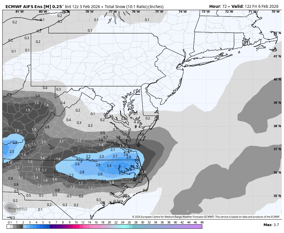
AIFS Ensembles beefed up.
packfan98
Moderator
BrickTamland
Member
Wow, that is quite a difference.AIFS Ensembles beefed up.
Hasn't run on SV yet, seems to be running late@RBR71 do you have the WeatherNext?
Btownheel
Member
Think the temps seeming to bust warmer this week (post storm cold push ended up over modeled) has an effect here? This is riding the marginal border hard.
Sent from my iPhone using Tapatalk
Sent from my iPhone using Tapatalk
BrickTamland
Member
HRRR

Raleighwxauthority
Member
My first call for this event includes 2-4" for Raleigh with 1-2" in CLT. I think Greenville, NC is the sweet spot with 3-6" there.
2-4" would be as wild as the snow hole last weekend. I think a dusting to an inch is generous with the conditions we will be up against.My first call for this event includes 2-4" for Raleigh with 1-2" in CLT. I think Greenville, NC is the sweet spot with 3-6" there.
I admire the bold pick! I personally think we squeeze out a dusting, but will take the 2-4''. 
1-2” in CLT?! I don’t think we see anything but a novelty flurry.My first call for this event includes 2-4" for Raleigh with 1-2" in CLT. I think Greenville, NC is the sweet spot with 3-6" there.
If temperatures were better, I'd feel better about the potential of getting a inch or two from this system for folks to the south of the NC/VA border counties. They will be marginal, at best, and usually that brings folks in RDU and surrounding areas a sloppy mess in situations like Thursday's event.
WolfpackHomer91
Member
I honestly don't see anyone South of HWY-58 IN VA having much luck here, as others have said.... temps are meh at best and this thing is weak. MAYBE extreme NE NC or the border ALL-Stars of Reidsville/ Roxboro. But imo as of now 58 in VA is the southern extent of anything noteworthy and by that I mean a quick 1-2". I-40 to HWY58 Possibly a Dusting but I doubt it, You will SEE snow with your eyes in Northern NC tomorrow but its not heavy enough to accumulate at 33-36
BrickTamland
Member
NAM only had a dusting in parts of NC.