lexxnchloe
Member
Would be awesome to see in a such a warm winter that these areas get a big snow. What is the Atlanta record for Feb snows?
Would be awesome to see in a such a warm winter that these areas get a big snow. What is the Atlanta record for Feb snows?
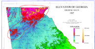
There is a max area of snowfall showing up now on almost all models. It is between Buchanan, Cedartown, Rockmart and Dallas, GA. NAM shows them switching over to snow earlier than other areas, around 10 pm Saturday. If that holds, they could see 5" to 6" maybe more. It's where the elevation jumps up a bit (over 1,000 ft and probably 1,100 to 1,200 on ridges). I'm at 850 so if it switches here, it's probably going to be one of the last spots in my area. I'll enjoy my digital hypothetical NAM'ing for a few more minutes!

Yes, a few years ago when this area of western Georgia got a foot of snow in that first week of December. I’m sure a totally different setup, but they weren’t calling for anything like that. Plus we’ve been known to get a decent snow or ice event on Super Bowl weekend lol
Very true. I think they were saying like an inch or two and then some areas got over 10". Seems like many of the best snows in GA kind of came as a surprise.Yes, a few years ago when this area of western Georgia got a foot of snow in that first week of December. I’m sure a totally different setup, but they weren’t calling for anything like that. Plus we’ve been known to get a decent snow or ice event on Super Bowl weekend lol


This would continue charlottes record of having measurable snow every year since records have been kept. I’m here for it. I’ll also be in Winston Salem and I’ll support this upper level low snow chaseNot mad at it, overall slightly better run the 18z, with slightly more snow east of the mountains View attachment 132862View attachment 132863View attachment 132864
Dang. Bullseye ~50 hours out. Feels…weird.
Areas in ETN went from nothing to over a foot in one run rotfl
Maggie Valley should do good with that lookNot mad at it, overall slightly better run the 18z, with slightly more snow east of the mountains View attachment 132862View attachment 132863View attachment 132864
Think I may chase this one a little. I'm willing to put my dog Ellie in the car and drive 30-40 miles for 6" if it doesn't set up nicely imby...This would continue charlottes record of having measurable snow every year since records have been kept. I’m here for it. I’ll also be in Winston Salem and I’ll support this upper level low snow chase


View attachment 132867
Old mean
View attachment 132868
New mean
Perhaps increased confidence in heavy snow making it into SW VA
