• Hello, please take a minute to check out our awesome content, contributed by the wonderful members of our community. We hope you'll add your own thoughts and opinions by making a free account!

12/8/2025 Event - Repeat of Last Week?

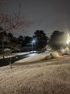
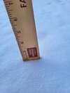
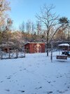
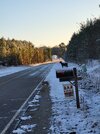
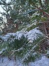
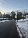
Well I gave up a little too early. We have about 1/2” and it’s absolutely beautiful out. This was definitely one I wish would keep going, but I’m very happy considering it seemed we were going to be blanked not long ago. Grass is covered and it is gorgeous outside with the Christmas decorations
 

Attachments

  • IMG_0756.jpeg
    IMG_0756.jpeg
    1.8 MB · Views: 59
  • IMG_0753.jpeg
    IMG_0753.jpeg
    2.3 MB · Views: 59
  • IMG_0754.jpeg
    IMG_0754.jpeg
    1.8 MB · Views: 59
Saw quite a few snow showers in the western triad but nothing accumulating. Congrats to those who got a coating in parts of Eastern/Central NC. While we saw more flakes with this one, the outcome was generally the same here as the last one, no snow even on the grassy areas at my house
 
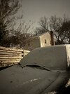
Final total 1/2” but I’m happy!!
d995ea0aae6a67517ee117f0282331a3.jpg


Sent from my iPhone using Tapatalk
 
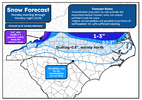
alright, less of a disaster this time around, but still PLENTY of room for improvement

going to have to split this one up into regions

recap:
-first of all, the high country blew past my expectations. I actually initially had 3-5" (locally 5"+) for pretty much all of watauga/ashe counties, which would have been a solid but still a bit below verification forecast, but i got scared and pushed it back to the border a little more. even eastern watauga managed 4-5". so, i take some consolation in having a pretty good forecast over there initially, but generally missed low for eastern high country (1-3" forecast, 4-5" verificaiton). locally 5"+ certainly verified, and i could have said 6 or 7 + and still been on target. so generally too conservative in the mountains (especially alleghany co, which did very well with 2-4" (where i forecasted a 2" ceiling. oof).
-further south in the mountains, generally more on target. lots of trace/dusting/0.5" reports down there. a bit too conservative for the smokies as well.
-outside the mountains, the most glaring issue i see is too aggressive on a dusting. from what i can tell this morning, that line should have followed the piedmont screw zone i drew in for the 0.5-2" and 1-3" contours MUCH more tightly. so, the southern and western parts of the dusting forecast failed.
-in northern and NE NC, it looks pretty good from what i can tell. i gave myself maybe a little too much of a range with that 0.5-2" zone, but i felt there was some boom potential still there and wanted to cover that some. in fact, there is a 2.0" report from just NW of rocky mount, which would imply 0.5-2 was actually a pretty realistic range for that zone as i am sure several around there only got an inch or so.
- the 1-3" zone looks solid to me. again, i am sure there were a few relative screw zones that fell shy or barely got to 1", but LSRs seem to line up decently well with the higher accumulation forecast zones on this map. even got a 1.1" from elizabeth city to verify the far eastern edge of this forecast

grade (mountains): C-, maybe D+. good in the lower accum zones, but conservative up top
grade (immediate piedmont): C-, too aggressive with the dusting generally, should have cut it north from western caldwell co to winston-salem and then followed I-40 down.
grade (north central/northeastern): A-, i can't find too many glaring issues out there as it stands.

overall grade: C+. mountains drag this one down for me. good out east, but a 3" ceiling turning into a 4-6" event with 6-8" up top is not good enough


1765292045280.png
 
alright, less of a disaster this time around, but still PLENTY of room for improvement

going to have to split this one up into regions

recap:
-first of all, the high country blew past my expectations. I actually initially had 3-5" (locally 5"+) for pretty much all of watauga/ashe counties, which would have been a solid but still a bit below verification forecast, but i got scared and pushed it back to the border a little more. even eastern watauga managed 4-5". so, i take some consolation in having a pretty good forecast over there initially, but generally missed low for eastern high country (1-3" forecast, 4-5" verificaiton). locally 5"+ certainly verified, and i could have said 6 or 7 + and still been on target. so generally too conservative in the mountains (especially alleghany co, which did very well with 2-4" (where i forecasted a 2" ceiling. oof).
-further south in the mountains, generally more on target. lots of trace/dusting/0.5" reports down there. a bit too conservative for the smokies as well.
-outside the mountains, the most glaring issue i see is too aggressive on a dusting. from what i can tell this morning, that line should have followed the piedmont screw zone i drew in for the 0.5-2" and 1-3" contours MUCH more tightly. so, the southern and western parts of the dusting forecast failed.
-in northern and NE NC, it looks pretty good from what i can tell. i gave myself maybe a little too much of a range with that 0.5-2" zone, but i felt there was some boom potential still there and wanted to cover that some. in fact, there is a 2.0" report from just NW of rocky mount, which would imply 0.5-2 was actually a pretty realistic range for that zone as i am sure several around there only got an inch or so.
- the 1-3" zone looks solid to me. again, i am sure there were a few relative screw zones that fell shy or barely got to 1", but LSRs seem to line up decently well with the higher accumulation forecast zones on this map. even got a 1.1" from elizabeth city to verify the far eastern edge of this forecast

grade (mountains): C-, maybe D+. good in the lower accum zones, but conservative up top
grade (immediate piedmont): C-, too aggressive with the dusting generally, should have cut it north from western caldwell co to winston-salem and then followed I-40 down.
grade (north central/northeastern): A-, i can't find too many glaring issues out there as it stands.

overall grade: C+. mountains drag this one down for me. good out east, but a 3" ceiling turning into a 4-6" event with 6-8" up top is not good enough


View attachment 178635
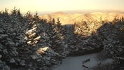
Yep I just looked and sugar mountain reported 6”. Nice little event up there
 
I’m
alright, less of a disaster this time around, but still PLENTY of room for improvement

going to have to split this one up into regions

recap:
-first of all, the high country blew past my expectations. I actually initially had 3-5" (locally 5"+) for pretty much all of watauga/ashe counties, which would have been a solid but still a bit below verification forecast, but i got scared and pushed it back to the border a little more. even eastern watauga managed 4-5". so, i take some consolation in having a pretty good forecast over there initially, but generally missed low for eastern high country (1-3" forecast, 4-5" verificaiton). locally 5"+ certainly verified, and i could have said 6 or 7 + and still been on target. so generally too conservative in the mountains (especially alleghany co, which did very well with 2-4" (where i forecasted a 2" ceiling. oof).
-further south in the mountains, generally more on target. lots of trace/dusting/0.5" reports down there. a bit too conservative for the smokies as well.
-outside the mountains, the most glaring issue i see is too aggressive on a dusting. from what i can tell this morning, that line should have followed the piedmont screw zone i drew in for the 0.5-2" and 1-3" contours MUCH more tightly. so, the southern and western parts of the dusting forecast failed.
-in northern and NE NC, it looks pretty good from what i can tell. i gave myself maybe a little too much of a range with that 0.5-2" zone, but i felt there was some boom potential still there and wanted to cover that some. in fact, there is a 2.0" report from just NW of rocky mount, which would imply 0.5-2 was actually a pretty realistic range for that zone as i am sure several around there only got an inch or so.
- the 1-3" zone looks solid to me. again, i am sure there were a few relative screw zones that fell shy or barely got to 1", but LSRs seem to line up decently well with the higher accumulation forecast zones on this map. even got a 1.1" from elizabeth city to verify the far eastern edge of this forecast

grade (mountains): C-, maybe D+. good in the lower accum zones, but conservative up top
grade (immediate piedmont): C-, too aggressive with the dusting generally, should have cut it north from western caldwell co to winston-salem and then followed I-40 down.
grade (north central/northeastern): A-, i can't find too many glaring issues out there as it stands.

overall grade: C+. mountains drag this one down for me. good out east, but a 3" ceiling turning into a 4-6" event with 6-8" up top is not good enough


View attachment 178635
what platform did you use to make this map?
 
Back
Top