GEFS significantly improved! 

Agree - there isn't really anything to stop this train of warmer air...The GFS is likely overstating the cold air based on its 850mb temperature anomalies and the associated storm track. While the model shows a substantial cold pool over the Southern Plains, it appears to exaggerate the eastward progression and strength of that cold air as the storm develops. This is evident in how the GFS depicts a broader area of snow and mixed precipitation further south and east than what might realistically occur, given the relatively weaker ridge dynamics and less supportive CAD setup.
The GFS seems to assume that the cold air will maintain its influence across the Southeast despite warm Gulf air overrunning the region. However, with the lack of a stronger ridge to hold the cold air in place and the storm track being more northerly, the warm air is likely to intrude faster than the GFS accounts for. This overstatement of cold air’s reach results in a colder, snowier solution that may not align with the overall pattern or the dynamics shown in other models. I really don't agree with this model run at all. Seems like a new pattern.

Wow! The mood swings with this storm are insaneView attachment 160078
For who?Icon much improved so far through 108
It's because people don't say who it's good or bad for, just assuming everyone knows what part of the SE they are talking about. That ICON run was clearly worse for a large part of the board, western areas to be more specific.One post says icon is better and one says it’s terrible. Lol
I’m pretty sure that’s not true for any of the vendors except possibly Storm Vista. Weatherbell and College of Dupage had precip types included.It’s good to keep in mind the GEFS counts any frozen precip as snow I think on the mean
Yeah but if it's ice storms you can have itAt first glance, like 90% of the GEFS members are WSW criteria wintry events for the upstate. Sheesh.


That's jumped the odds of 4+ to a good chance for many:So many GEFS bombs

That's jumped the odds of 4+ to a good chance for many:

oh yeah that probably helped
That's great, it doesn't support the 18z GFS operational
That's where all those AI models were winding up too at 12z. Good sign for Eastern NC.
Yes. Snow depth is 'considered' by models **except for current AI models**. AI models do not currently consider snow depth in their calculations, interestingly enough. Will have to watch and see what kind of impact this may have.Will the models pick up on the snow pack currently falling in the Midwest?
Sent from my iPhone using Tapatalk
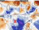
How can anything be aligned with this? It's like a bucking bronco.This comparison of the GEFS, ECMWF AI, and GFS highlights stark differences in how each model handles the storm evolution, with the GFS emerging as a significant outlier. Let’s break down these patterns and assess the plausibility of each. (I know this is long, but encourage to read)
GEFS (Top Left)
- Pattern Overview:
- The GEFS shows a textbook setup for a high-impact winter storm. A deep, well-amplified trough is centered over the central U.S., with cold air anomalies extending far south into Texas and the Gulf states.
- A strong ridge is firmly established over the western U.S., allowing the jet stream to buckle significantly, promoting a southward surge of Arctic air.
- Cold air damming (CAD) is supported by robust Arctic high pressure over eastern Canada (circled in orange), creating an ideal environment for cold air to funnel south and remain entrenched across the eastern U.S.
- Implications:
- The alignment of the trough and the strong ridge supports a suppressed storm track (white arrow), keeping the system farther south where it interacts with Gulf moisture.
- This configuration is highly favorable for widespread snow and wintry precipitation across the Midwest, the Tennessee Valley, and potentially the Southeast. The CAD feature ensures cold air remains in place for regions on the northern and western periphery of the low-pressure system.
- Forecast Confidence:
- The GEFS solution is meteorologically sound, as it relies on well-established teleconnections such as strong ridging in the West and Arctic high placement. It aligns with climatological patterns for significant winter weather in these regions.
- This scenario is supported by current trends in large-scale dynamics, lending greater credibility to this solution.
ECMWF AI (Top Right)
- Pattern Overview:
- The ECMWF AI closely resembles the GEFS but with some notable differences. The trough is still well-defined but not as deep or expansive as in the GEFS.
- Cold air anomalies remain present but are slightly less intense and do not extend as far south. The storm track (white arrow) is still suppressed but shows hints of a more progressive system.
- Implications:
- While the ECMWF AI still supports a wintry outcome, it introduces a slightly greater risk of warm air intrusion, particularly for areas in the Southeast where Gulf moisture could override marginal cold air.
- This pattern remains supportive of snow and mixed precipitation across the Midwest and interior Southeast but suggests a narrower corridor of impactful wintry weather compared to the GEFS.
- Forecast Confidence:
- The ECMWF AI offers a slightly less aggressive cold air solution but still maintains strong meteorological validity. Its alignment with the GEFS adds weight to the likelihood of a southern storm track and a colder, wintry outcome.
GFS (Bottom)
- Pattern Overview:
- The GFS diverges dramatically from the other two models. It features a flatter, less amplified trough, which fails to dig deeply into the central U.S.
- Ridging over the western U.S. is weaker and less defined, resulting in a more zonal flow that limits the southward extent of cold air.
- Warm air from the Gulf (orange arrow) dominates, with the storm track (black arrow) shifting significantly farther north.
- Implications:
- This setup leads to a predominantly rain-driven system across much of the Southeast and Mid-Atlantic, with limited snow confined to the northern Great Lakes and extreme interior regions.
- The lack of strong ridging in the West and the absence of robust Arctic air intrusion make this scenario far less favorable for widespread wintry weather.
- Forecast Confidence:
- The GFS solution appears fundamentally flawed given the current synoptic setup. Its weaker western ridge and failure to amplify the trough are inconsistent with the large-scale atmospheric trends observed in other model guidance.
- The GFS’s northward storm track contradicts established forcing mechanisms, such as CAD and the southward shift of Arctic air. It essentially dismisses the role of the eastern Canadian high, which is critical for anchoring cold air in the eastern U.S.
Key Differences:
- Trough Amplification:
- The GEFS and ECMWF AI feature deeper and more amplified troughs, consistent with a stronger western ridge. The GFS, in contrast, displays a flatter and less impactful trough.
- Storm Track:
- GEFS and ECMWF AI favor a suppressed storm track, allowing cold air to dominate and increasing the likelihood of snow and mixed precipitation in the South and Southeast. The GFS pushes the track farther north, introducing significant warm air and rain.
- Cold Air Support:
- Both GEFS and ECMWF AI highlight strong Arctic high pressure in eastern Canada, locking in cold air. The GFS downplays this feature, undermining its cold air source.
Plausibility and Final Thoughts:
- The GEFS and ECMWF AI solutions are far more credible, as they are grounded in strong ridging over the West, a well-defined Arctic high, and large-scale dynamics that support cold air intrusion and a southern storm track.
- The GFS, by comparison, is likely overestimating the influence of Gulf warmth and underestimating the ability of the ridge and Arctic high to anchor the cold air. This results in a warmer, rain-dominated solution that seems less consistent with the broader pattern.
Verdict:
Given the alignment between the GEFS and ECMWF AI (GEFS caving in the EURO AI model), and the robust synoptic reasoning behind their solutions, the GFS appears to be an outlier and likely incorrect in this case. Observational trends over the coming days should further clarify which models hold steady and which begin to cave. (I cant belive im saying this but) For now, the colder, suppressed storm track remains the more scientifically sound expectation.

I agree the GEFS solution does look a bit aggressive, but I think it's important to consider the large-scale dynamics that support its amplification. The strong western ridge and robust Arctic high-pressure system shown in the GEFS align with the broader synoptic trends we're seeing. It could simply be capturing the sharp contrasts between the deep trough and the amplified ridge. If anything, it's worth watching to see if future runs smooth out or if other models begin trending toward a more amplified solution.

What we want to see. If we can get these two to agree and the EPS to start agreeing too I think we can let the OP models go nuts for a few runs before we start to see them settle on that solution too, if that's where we end up. I expect we see more consistency tomorrow and by Tuesday we should have our answer.18z gefs mean looks like the 12z AI at H5 for the most part
Oh just to be clear, I think the GEFS is going to continue to amp up more. But it is about the last piece of modeling guidance I would be consulting for this event. A low res, already piece of garbage model (IMO) with less complex systems that has the least dispersiveness of any ensemble suite is not the one to be looking to in an extremely complex phasing scenario. IMO, the ops will lead the ensembles even more in this setup.I agree the GEFS solution does look a bit aggressive, but I think it's important to consider the large-scale dynamics that support its amplification. The strong western ridge and robust Arctic high-pressure system shown in the GEFS align with the broader synoptic trends we're seeing. It could simply be capturing the sharp contrasts between the deep trough and the amplified ridge. If anything, it's worth watching to see if future runs smooth out or if other models begin trending toward a more amplified solution.
Fair points about the GEFS's limitations in resolution and handling phasing scenarios, but I’d argue it still has value in capturing broader trends. While it might 'amp up' further, the alignment between GEFS and ECMWF AI on the ridging and trough setup is worth noting. Ensembles also help provide a probabilistic lens that operational models sometimes miss. That said, I agree that watching the ops closely—especially ECMWF—will be key for resolving the details in this complex scenario. But lets hope it does amp it upOh just to be clear, I think the GEFS is going to continue to amp up more. But it is about the last piece of modeling guidance I would be consulting for this event. A low res, already piece of garbage model (IMO) with less complex systems that has the least dispersiveness of any ensemble suite is not the one to be looking to in an extremely complex phasing scenario. IMO, the ops will lead the ensembles even more in this setup.
 , but I do agree.
It still just seems like a middle ground as far as Upstate goes. Just had that feel of a Front end Thump Transition to Sleet/ZRI know we are going to laugh but that 18z ICON was like the perfect blend of the GFS and EURO and matches up well with the AI models and the latest GEFS.
ICON does offer an interesting middle ground between the GEFS and ECMWF, but it seems to lack the deeper cold air intrusion needed for a significant winter weather event. The 850mb temperature anomalies, while showing some colder air, appear underdone compared to what the GEFS and ECMWF AI are indicating. This makes it feel closer to the GFS solution, which also struggles with fully locking in the Arctic air. The ICON’s setup is decent but might end up underestimating the role of the stronger ridging out west and the eastern Canadian high in driving colder air further south. It’s worth watching, but I’d be cautious about leaning too heavily on it given these limitations.I know we are going to laugh but that 18z ICON was like the perfect blend of the GFS and EURO and matches up well with the AI models and the latest GEFS.
 EURO still ends up here but it was improved at H5 earlier in the run
Any snow maps ?View attachment 160088EURO still ends up here but it was improved at H5 earlier in the run